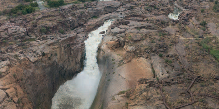
ABOVE: Below the Augrabies Falls the Orange River wends its way through rugged, spectacular scenery.
The course the mighty Orange River carved through the landscape in its middle and lower reaches brings life to an inhospitable area where only the hardiest can survive. Away from the lush banks with their verdant vineyards the terrain alternates between red sand dunes and gently undulating sand and gravel plains dissected by ancient dry river courses and vast pans.
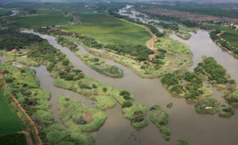
The Orange River Valley occupies one of the most remote corners of the Northern Cape. It stretches along either side of the middle and lower reaches of the Orange River, from Groblershoop in the east to Goodhouse in the west. With its abundance of water, alluvial soil and warm climate, the Orange River Valley is a fertile agricultural area. Crops include sultanas, table and wine grapes, lucerne, wheat, maize, beans, peas, lentils and groundnuts.
The Orange River Valley is blessed with an abundance of sunshine. Summer stretches from October to March and temperatures of between 35 °C and 40 °C in midsummer are the rule rather than the exception. A record high of 47,8 °C was recorded at Goodhouse on the Orange River in 1939. Daytime temperatures in winter (April to September) are mild and enjoyable, but the nights can be chilly.
Rain occurs during the summer months when heavy afternoon thundershowers bring temporary relief from the oppressive heat. Rainfall ranges between 50 mm and 400 mm per annum, but is unpredictable. Prolonged droughts are a common occurrence.
The vegetation ranges from thickets along the Orange River to Karoo plains dotted with dwarf shrubs, small trees, annuals and short grasses. Fields of bright yellow devil’s thorns are conspicuous after good summer rains when a variety of other creepers and flowers also come into bloom.
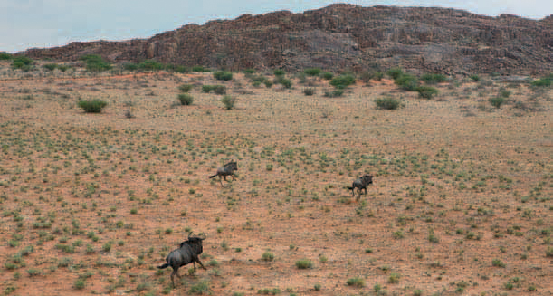
The large herds of springbok and other game encountered by early travellers and explorers have long since disappeared, but the Augrabies Falls National Park and private game farms offer opportunities to view typical plains antelope such as gemsbok and springbok, as well as blue wildebeest, red hartebeest and eland.
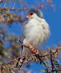
The enormous communal weaver nests clinging sociably, but precariously, to telephone poles are a familiar site along roads in the region. Keep an eye out for pygmy falcon, which can often be spotted in the vicinity of the nests. A variety of larks, typical Karoo species such as Burchell’s courser and Ludwig’s bustard, and a rich diversity of raptors can also be seen.
ABOVE: The pygmy falcon, southern Africa’s smallest diurnal raptor, is closely associated with sociable weaver nests, which they use for roosting and nesting.
ABOVE: Blue wildebeest, close relatives of black wildebeest, race across sparsely vegetated plains.
San hunter-gatherers roamed the plains and dunes for thousands of years before Koranna pastoralists moved in. The islands in the middle reaches of the Orange River provided a safe haven for rival Koranna groups, while freebooters and renegades fleeing the authorities at the Cape also sought refuge there, as did people of mixed descent, Dutch hunters and trekboers (migratory stock farmers).
By the mid-1800s, the northern frontier had become notorious for its illegal trade in firearms and alcohol, skirmishes and commando-style stock raids. To bring order to the lawless region, British forces fought two wars against the Koranna: the first from 1868–69 and the second from 1878–79. A peace agreement was reached in January 1880, and the agricultural industry along the Orange River was established in 1883, when the first irrigation canals were built at Upington.
Groblershoop, a centre of the surrounding grape- and livestock-farming district, developed around a camp built to house workers during the construction of the Boegoeberg Dam in 1929. The 10-m-high weir and irrigation canals were built by white labourers left destitute by the Great Depression and a devastating drought.
Attractions in the area include the historic (1911) water turbines built on the farm Win-stead, 25 km from Groblershoop on the road to Griquatown. Also to be seen on this farm is a military cemetery where seven South African soldiers were buried in November 1914 after a battle with rebels loyal to Boer General Manie Maritz. The rebels were on their way to join Maritz, who was sympathetic to the German administration in South West Africa (now Namibia), when the two sides clashed.
Upington, the commercial centre of the region, was founded in 1871 as a mission station named Olyvenhoutsdrift (‘ford of the olive trees’) by a Rhenish missionary, Reverend Christiaan Schröder. When the town was proclaimed in 1884 it was named after Sir Thomas Upington, Prime Minister of the Cape Colony from 1884–86.
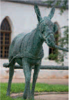
Two rather unusual statues can be seen in the town. The life-size bronze donkey in the grounds of the Kalahari Oranje Museum is a tribute to the contribution this animal made to the region’s early development; the camel-and-rider in front of the police station recalls the days when the police patrolled their vast territory on camels, which were ideally suited to the desert terrain.
Domestic implements and photographs documenting the history of Upington and the Lower Orange River area are displayed in the Kalahari Oranje Museum. Originally, the building housed the historic Rhenish Mission church, consecrated in 1875. The adjacent parsonage was added eight years later.
ABOVE: Verdant vineyards grow along the Orange River, in sharp contrast to their arid surroundings.
More than 200 date palms line the 1 041-m-long Palm Tree Avenue leading to The Eiland Holiday Resort on Olyvenhout Island. Planted in 1935, it is one of the longest and densest palm avenues in the Southern Hemisphere.
Upington is a major centre of the dried fruit industry and each year many tonnes of sultanas and raisins are processed at the South African Dried Fruit Co-operative – the second largest factory of this kind in the world. Visitors can purchase dried fruit on site.
The Spitskop Nature Reserve, 13 km north of the town, has been stocked with herds of gemsbok, springbok, red hartebeest and eland.
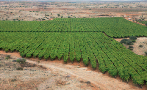
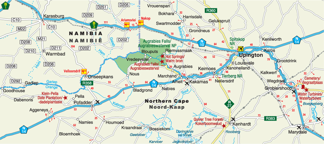
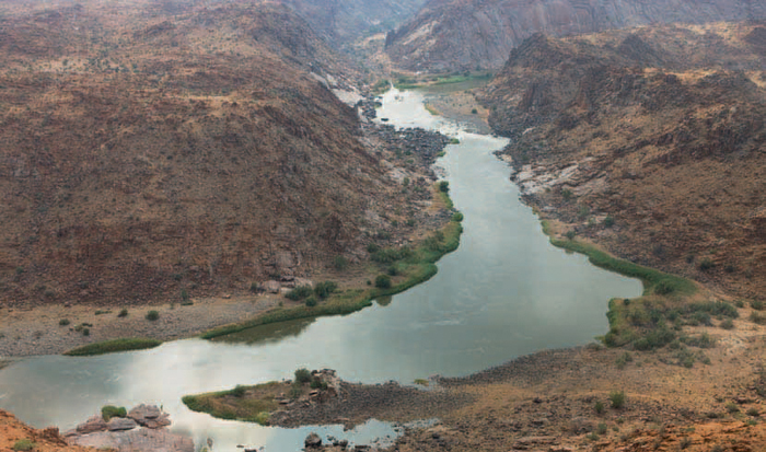
The name Kanoneiland (‘cannon island’) recalls the region’s turbulent pioneering days when Koranna river pirates, based on the island, were bombarded with a cannon for six days in 1878, during the Second Koranna War. Half a century later, 52 farmers defied government orders prohibiting the occupation of Orange River islands and began cultivating crops there. Over the years the 50-odd islands were linked by landfills, and today Kanoneiland, about 14 km long and 3 km wide, is the largest inhabited inland island in South Africa.
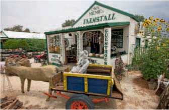
At Keimoes the Orange River splits into a labyrinth of channels to create a mosaic of islands linked by roads and footbridges. Keimoes is famous for its bakkiespomp (waterwheel) mounted on the water furrow along the main street.
Diagonally across from the waterwheel is the historic Dutch Reformed Mission church, which was built in 1889 and used as a school until 1916. The neo-Gothic windows were added in 1920.
Nature lovers can explore the Tierberg Nature Reserve and enjoy spectacular views from its lookout point. In August and September the drab rocks are adorned in red as thousands of Gariep aloes burst into bloom.
The pleasant country town of Kenhardt played an important role in bringing order to the northern frontier in the second half of the 19th century. A camel thorn tree marks the spot where Magistrate Maximillian Jackson and his police force spent the night of 27 December 1868, en route to the volatile Lower Orange River.
ABOVE: Kanoneiland in the Orange River has been turned into highly productive agricultural land.
ABOVE: Kenhardt’s old buildings lend the town an atmosphere reminiscent of the days when it was one of the most remote settlements in the Northern Cape.
ABOVE: The historic bakkiespomp (waterwheel) along the main street in Keimoes is a heritage site, as is the Dutch Reformed Mission church diagonally across.
ABOVE: Upington’s Donkey Statue is one of only two statues in South Africa that pays tribute to the role this draught animal played in the development of the region.
ABOVE: Augrabies Falls, one of the world’s great cataract-type waterfalls, is one of South Africa’s natural wonders.
Founded in 1876, Kenhardt was once the most remote administrative, police and military outpost in the northwestern Cape. The old library (1897) with its corrugated iron roof and plain veranda is an excellent example of a typical pioneer house.
About 8 km south of town the plains give way to dolerite outcrops where an unusually dense concentration of 4 000–5 000 quiver trees has created a ‘forest’ of tree aloes.
Kakamas was established in 1897 by the Dutch Reformed Church as a settlement for farmers impoverished by drought. The extensive system of irrigation canals and furrows they built laid the foundations for today’s vineyards and fields of lucerne and cotton. On the farm Baviaans Kranz, a few kilometres east of Keimoes, Cornish miners dug two tunnels through solid rock. Work on the 97-m and 172-m-long tunnels was completed in 1911.
Kakamas is famous for its waterwheels on the outskirts of the town many of which are still in working order. Also of interest is the old Transformer Building, which housed one of South Africa’s first hydroelectric power stations. The double-storey building resembles an Egyptian temple and was completed in 1914.
The first sultana vine was planted in Kakamas in 1928, and the Orange River Valley is now the major producer of sultanas in South Africa. The town is also famous for the Kakamas peach, a yellow clingstone variety ideally suited to canning.
A rocky koppie (hillock), 4 km east of Kakamas on the road to Keimoes, marks the spot where seven German and two South African soldiers were killed when a German force attempted to open a corridor from South West Africa (now Namibia) into South Africa in February 1915.
Riemvasmaak, a little-known tract of semi-desert land defined by the Namibian border in the west and the Orange River in the south, made headlines when the first land restoration claim was awarded to the former inhabitants of the area in February 1994.
The Riemvasmakers, as they are generally known, trace their origins to a group of pastoralists under the leadership of Koning (King) Dawid, who settled here in the 1870s after fleeing conflict in southern Namibia. People of mixed descent and Xhosa-speaking migrants also settled here and a Roman Catholic mission station was established in 1947 to serve the spiritual needs of the community.
Riemvasmaak’s 1 500 residents were forcefully removed to Namibia and the Eastern Cape in 1973 and 1974 when the area was declared a military training ground by the then South African Defence Force.
Following their successful land claim in 1994, the first Riemvasmakers returned from Namibia in March 2005. Currently, agriculture centres on goat, sheep and cattle farming, as well as table-grape production at Vredesvallei (‘valley of peace’) along the Orange River.
Millions of years of erosion have fashioned a landscape of dolerite outcrops, flat-topped mountains, plains and sand dunes. The usually dry Molopo River has carved a spectacular 80-m-deep gorge through the rugged landscape and the hot spring that rises from its rocky bed is a lifeline to the people of Riemvasmaak. It is also a popular campsite for outdoor enthusiasts.
At Augrabies, the Orange River has carved a deep passage through the granite rocks to create one of the world’s great cataract-type waterfalls. Viewing platforms afford awe-inspiring vistas of the main fall, which plunges 56 m into an 18-km-long gorge with sheer, smooth walls. When the Orange River is in full flood a curtain of water thunders into the gorge, which has an average depth of 240 m. The Khoekhoen appropriately named this spectacle Akoerabis – ‘the place of the great noise’. Self-drive routes lead to vantage points such as Ararat and Oranjekom from where there are good views of the gorge and the swirling river far below.
A scramble up Moon Rock, which can either be reached on foot or by car, provides a 360-degree view of the surrounding landscape. The granite-gneiss outcrop, or whaleback, is an excellent example of onion-skin weathering, which is the flaking off of slabs of rock.
Giraffe, kudu and herds of gemsbok, springbok, red hartebeest and eland roam the game-viewing area, while the rocky terrain is an ideal habitat for klipspringer as well as family groups of baboon and rock dassie. Cape clawless otter, ground squirrel, bat-eared fox and vervet monkey are among the smaller mammals to be seen. Guided night drives may provide glimpses of nocturnal animals such as leopard, caracal, small-spotted genet and aardvark.
Accommodation is available in stone chalets and there are shaded campsites. Facilities include picnic sites for day visitors, two swimming pools, a restaurant, shop and filling station.
Nestling in a valley between rugged hills, Pella’s palm trees and lush green gardens appear like an oasis. The settlement was founded in 1814 by the London Missionary Society for Khoekhoen who had fled conflict in southern Namibia.
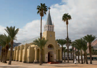
Pella was abandoned in 1872, but the mission station was reopened when the Roman Catholic Church established its presence in the Northern Cape in 1878. Construction of a cathedral started in 1888, and it took seven years of hard labour before it was inaugurated in 1895. Wounded German soldiers were treated in the church hall that served as a hospital during World War I, when South African troops invaded South West Africa, then under German administration.
Other reminders of Pella’s origins include the marble tombstones of the founding Catholic missionaries and the historic millstone, which dates back to the end of the 1800s.
With some 14 000 palms under cultivation, the date plantation at Klein Pella, about 25 km west of Pella, is the largest in the Southern Hemisphere. The picking season extends from mid-February to April.
ACTIVITIES
• Mountain and quad biking at Riemvasmaak
• Gariep 3-in-1 Adventure, a combination of canoeing (3 km), hiking (4 km) and mountain biking (11 km) in the Augrabies Falls National Park
• Game viewing at Spitskop Nature Reserve and Augrabies Falls National Park
• Waterfall viewing, picnicking, swimming and camping at Augrabies Falls National Park
• Date picking at Klein Pella from mid-February to April
ABOVE: Pella’s Roman Catholic church, built in Roman and Gothic styles, took seven years to build.
ROUTES AND TRAILS
• Three 4x4 trails (41–71 km) at Riemvasmaak
• Rockery Route (44 km) along a scenic gravel road between Kakamas and Neilersdrif near Keimoes; suitable for sedan cars
• Hiking trails of varying length and moderate difficulty at Riemvasmaak
• Dassie Nature Trail (2 hours), a self-guided interpretative walk in Augrabies Falls National Park
• Self-guided circular Klipspringer Hiking Trail (3 days) in Augrabies Falls National Park