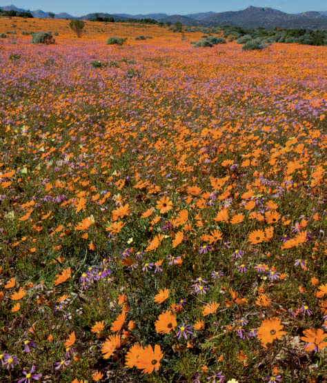
ABOVE: Fields of the glansooggousblom, an indigenous daisy, transform the landscape of the Namaqua National Park into an orange blaze in spring.
Namaqualand, a vast arid region in the northwestern corner of South Africa, is renowned for its spectacular seasonal displays of spring flowers. Nature has blessed this area, aptly named the ‘Garden of the Gods’ by photographer Freeman Patterson, with a wealth of succulents.
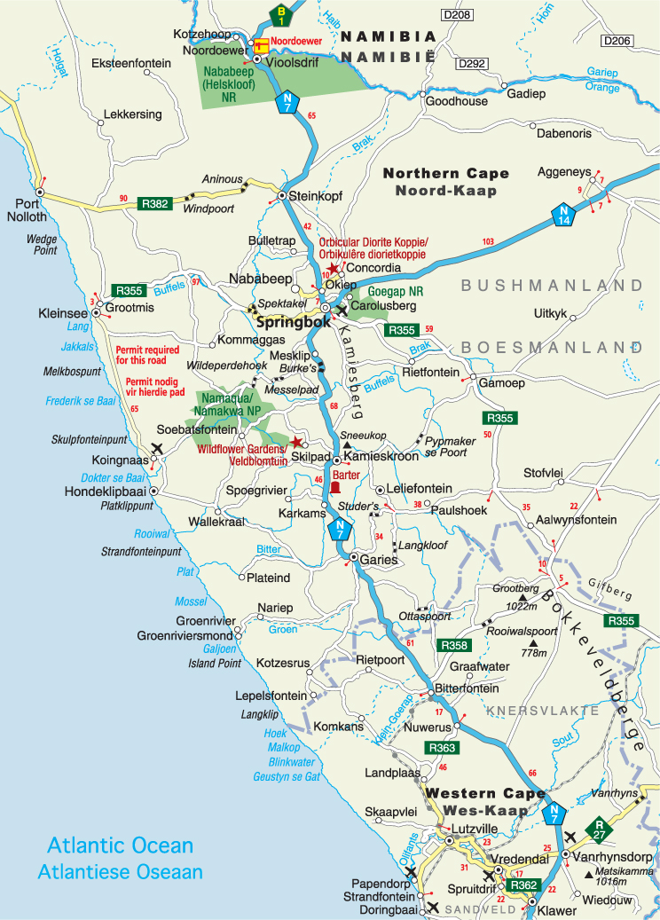
The rolling hills strewn with small quartz pebbles, and red sandy plains in the south of Namaqualand, are known as the Knersvlakte – a name alluding to early travellers, who gnashed their teeth when travelling through this harsh and waterless terrain. North of Nuwerus, the Knersvlakte gives way to the smooth round granite hills and domes of the Namaqualand Klipkoppe (‘rocky hills’). To the west lies the sandveld, a 30-km-wide strip of white and red sandy soil extending from the Olifants River northwards along the coast. The Orange River forms the northern boundary, while the Bokkeveldberge and the escarpment, and the Atlantic Ocean make up the eastern and western boundaries respectively.
Small-stock farming and wheat production are the main agricultural activities. The region is also rich in copper ore and diamond deposits, while gypsum is mined on the plains just north of Vanrhynsdorp. There are also marble and granite mines in the region.
Situated in a semidesert area, the climate of Namaqualand is one of extremes. Midsummer temperatures are swelteringly hot, but it can be freezing cold in winter. Namaqualand lies in a winter rainfall area and precipitation varies from less than 50 mm at the coast to 200 mm a year further inland. Fog is common along the coast.
Namaqualand is synonymous with mass displays of annuals – among them the Namaqua daisy and species with descriptive names like botterblom (‘butter flower’), beetle daisy and gansogie (‘goose eye’).
The secret of Namaqualand’s floral displays lies in the way the plants have adapted to survive the harsh conditions. After the first good winter rains the seeds of the annuals germinate and for a few weeks the drab landscape is transformed into a blaze of colour – provided there have been good follow-up rains to ensure that the plants reach maturity.
The peak flowering season is usually from early August to mid-September. By the end of September the flowers wilt and disperse their seeds, which then lie in wait for the next year’s rains. In order to survive, the seeds have ingenious built-in safety mechanisms. Each species has its own temperature and moisture requirements for germination and not all the seeds germinate after one good shower. This ensures that the natural seed bank is not depleted if there are no follow-up rains to sustain the new growth.
The flowers are usually at their best between 10h00 and 16h00 on sunny, windless days. They should be viewed from the north (with the sun behind the viewer), as the flowers orientate themselves towards the sun.
Succulents account for a third of the region’s more than 3 000 plant species and include miniature ‘stone plants’ (lithops) and a rich variety of mesembs, commonly referred to as vygies.
More than 480 species of geophytes occur in the region. They escape the relentless summer heat because their bulbs, corms and tubers are protected underground. Water is retained in their underground storage organs to sustain them during droughts.
The harsh environment does not support many large mammal species, but the region is rich in reptiles, including many endemic species such as the Namaqualand dwarf leaf-toed gecko, the Rooiberg girdled lizard and the Namaqua dwarf adder.
Birding is best in winter and spring and Karoo eremomela, cinnamon-breasted warbler, Verreaux’s eagle, ground woodpecker and mountain wheatear are among the species likely to be seen.
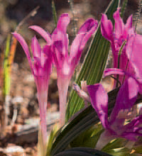
ABOVE: Namaqualand is renowned for its extraordinary diversity of spring annuals, perennials, succulents and geophytes such as this beautiful pink bobbejaantjie.
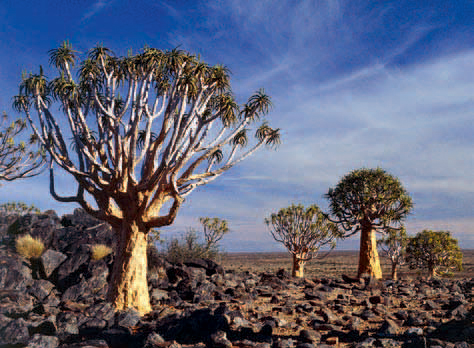
ABOVE: The branches of quiver trees are covered in a thin layer of whitish powder that helps to deflect the sun’s hot rays.
The region is home to the Nama people, a Khoekhoe group that migrated from northern Botswana westwards along the Orange River some 2 000 years ago and then split into two groups. The Little Namaqua settled south of the Orange River, while the Great Namaqua occupied southern Namibia.
Copper bangles worn by the Khoekhoen aroused the interest of officials of the Dutch settlement established at the Cape by Jan van Riebeeck in 1652. The first expeditions to find the source of the copper set out north, and by 1660 the Olifants River was reached.
Following the return of Ensign Isaq Schrijver from the Khamiesberg with samples of copper in 1684, Governor Simon van der Stel led an expedition to Namaqualand the following year. After a two-month journey, the expedition reached the ‘copper mountain’. One of the mineshafts dug by the expedition in 1685 can still be seen at the Koperberg, near the disused Carolusberg mine, a few kilometres east of Springbok.
However, commercial exploitation of copper in Namaqualand only began in 1859. Over the next 140 years, vast quantities of ore were extracted from 23 mines in the area, but by the beginning of the 21st century the last mine was closed.
Set against the backdrop of the Matsikamma Mountain, Vanrhynsdorp, the southernmost town in Namaqualand, was established on farm land in 1751. Originally named Troe-Troe, the settlement was renamed Vanrhynsdorp in 1881 after the owner of the farm.
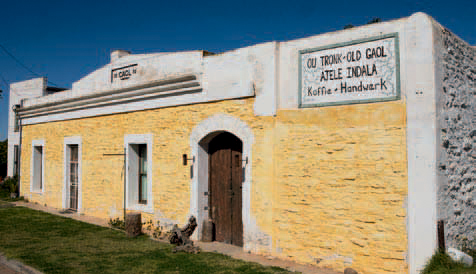
The town has a distinctly Victorian atmosphere with many well-preserved houses dating back to the early 1900s. The old gaol, built in 1895, now houses the Vanrhynsdorp Museum and the tourism bureau. The town is a popular refilling stop on the N7.
ABOVE: Fields of annuals carpet the usually barren Namaqualand plains for a few weeks each spring.
ABOVE: Vanrhynsdorp’s historic old gaol was built more than 100 years ago in 1895.
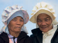
ABOVE: Some Nama women may still be seen wearing the traditional Nama kappie – a large white bonnet made from linen.
A unique collection of valve radios and wireless equipment dating back to 1920 is displayed in the Latsky Radio Museum – a private collection that is open only during the flower season or by appointment.
Many rare succulents are among the 500 plant species on sale at the Kokerboom Nursery in the town, which is the largest indigenous succulent nursery in South Africa.
Rock paintings, including red and ‘decorated’ hand prints, human figures and images resembling nets, can be seen south of Vanrhynsdorp at Wiedouw and further along in the Gifberg (‘poison mountain’), so named for the endemic hyaena poison-bush.
Heading north from Vanrhynsdorp, the N7 passes the towns of Nuwerus and Bitterfontein before reaching Garies. Situated midway between Vanrhynsdorp and Springbok, Garies was laid out against the backdrop of granite hills after land was made available for a Dutch Reformed church in 1845.
British forces occupied a cluster of granite outcrops overlooking the town from 1901 to 1902 during the second Anglo–Boer War. The lookout was fortified with stone walls and during their free time the soldiers engraved their names and regimental badges into the rock.
The outcrop, which has since become known as Letterklip (‘alphabet rock’), is about 1 km from the town on the Studer’s Pass.
The tranquil town of Kamieskroon was named after the crown-shaped rock on the crest of the Khamiesberg. Dominating the landscape to the northeast of the town, the 1 591-m-high Sneeukop is the second-highest point in Namaqualand.
The first Dutch Reformed church in Namaqualand was built in 1864 in a valley on a farm 6 km north of Kamieskroon. When it became obvious that the valley was too small for the Bowesdorp settlement, which had grown around the church, Kamieskroon became the new centre of the surrounding farming community in 1924.
The town is an ideal base for a day drive to Leliefontein Mission Station, which lies to the east of the Khamiesberg, an area that is home to some 1 000 plant species.
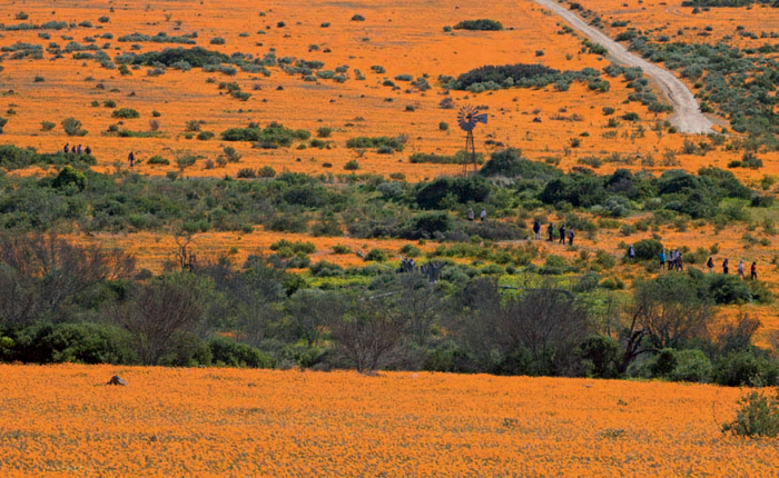
The Namaqua National Park northwest of Kamieskroon is renowned for its springtime carpets of orange daisies. The park’s foundations were laid in 1998 with the establishment of the Skilpad Wildflower Reserve by the World Wide Fund for Nature (WWF). The Namaqua National Park was officially opened in August 1999 and has since been enlarged to include the low-lying sandveld to the west. Plans are afoot to extend the park eastwards to incorporate the Khamiesberg where many endemic succulents occur.
The most spectacular wildflower displays can be found on former wheat fields in the Skilpad section of the park that are dominated by two showy daisy species – one with orange ray florets and the other with black disc-like florets. A variety of other annuals, geophytes and perennial species also thrive in the surrounding unploughed areas. Succulents and perennial bushes grow among the granite outcrops and in the adjacent mountains. Typical sandveld vegetation occurs on the low-lying coastal plains.
Picnic facilities are provided for day visitors and self-catering accommodation is available. The reserve is reached 22 km northwest of Kamieskroon along a gravel road.
Situated in the eastern foothills of the Khamiesberg, the settlement of Leliefontein lies along what has aptly been named the Garden Route of Namaqualand.
The oldest Methodist mission station in the country was founded here by the Reverend Barnabas Shaw in 1816. The historic church dates back to 1855, while the adjoining parsonage was built a few years earlier.
A plaque in the church serves as a memorial to the 35 inhabitants massacred by a Boer war force under the command of General Manie Maritz in January 1902. An altercation broke out when they were accused of being sympathetic to the British, after which Maritz ordered their annihilation.
The choice of a port from which to export copper originally fell on Hondeklip Bay. The town owes its name to a 5-m-high rock (klip) that resembled a seated dog (hond) – until its ‘head’ was struck off by lightning.
The settlement was declared a magisterial district in 1862 and the rough track along which the copper was transported from Springbok to the coast was improved when the Messelpad Pass (named after dressed-stone embankments) was built between 1867 and 1869.
However, the completion of the railway line to Port Nolloth brought about the rapid decline of the settlement, and these days it functions predominantly as a summer-holiday destination for Namaqualand farmers.
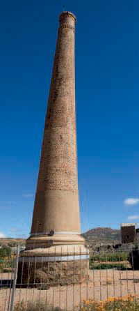
Springbok, the commercial centre of Namaqualand, owes its existence to the rich copper deposits occurring in the area, known to geologists as the Okiep Copper District. The opencast Blue Mine, on the northwestern outskirts of the town, came into operation in 1852 and was the first commercial mine in the country. The stone smokestack built at the Springbokfontein reduction works in 1863 is a reminder of the town’s early mining days.
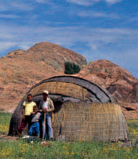
ABOVE: The traditional Nama home, the matjieshuis, was ideally suited to the nomadic lifestyle of the Nama.
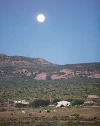
ABOVE: Namaqualand is a sparsely populated region with wide-open spaces interspersed by granite hills.
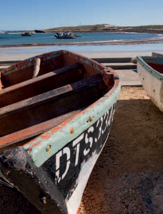
ABOVE: Fishing boats at Hondeklip Bay wait to go to sea to haul in the rich harvests of the Atlantic Ocean.
Services of the first Dutch Reformed church congregation were held in an oblong stone building, built in 1877, until the new dressed-stone church was taken into use in 1921. Springbok’s synagogue was built in 1929 when the town had a sizeable Jewish community, but now serves as the town’s history museum.
The Goegap Nature Reserve, 15 km southeast of Springbok, is a sanctuary for Hart-mann’s mountain zebra, gemsbok, springbok, klipspringer and a host of small mammals and birds, including flocks of ostrich. For most of the year the reserve attracts few visitors, but in the spring flower season large numbers of people pass through the gates to enjoy the spectacular natural floral show. A succulent display and a rock garden have been developed in the Hester Malan Wild Flower Garden that forms part of the reserve.
More than a decade after the first shaft was sunk at Okiep in 1856, the mine was ranked as the richest copper mine in the world. It eventually closed in 1971, and in 1997 the houses in the town were given to the people who occupied them at that time. Relics of Okiep’s mining history include the old smelter stack, which was in use from 1880 to 1929, and the adjoining steam-driven Cornish beam pump erected in 1882 to pump water from the mine.
Exploitation of copper ore at Nababeep began in 1857. Closed in 1919, the mine reopened in 1939, but mining activities finally ceased in the early 1980s. The smelter, however, was kept going with concentrates until December 2003, when it, too, was shut down.
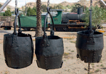
The history built on the region’s copper riches is the theme of the Nababeep Mine Museum. Clara, the quaint steam engine in front of the museum, was the last steam locomotive used on the Okiep–Port Nolloth narrow-gauge railway line, which was closed in 1941 after the track proved to be uneconomical.
ABOVE: The historic smelter stack at Okiep was built by Cornish miners in 1880 for the boilers that supplied steam for the nearby Cornish beam pump.
ACTIVITIES
• Canoeing on the Orange River; several operators conduct trips from base camps downstream of Vioolsdrif or Noordoewer in Namibia
• Mountain biking in the Goegap Nature Reserve and in the Khamiesberg, along the road to Leliefontein
• Experiencing Nama culture at Paulshoek in the Khamiesberg
• Birdwatching all over the region
ABOVE: Clara, a narrow-gauge locomotive used on the Okiep– Port Nolloth line, is the centrepiece of the displays at the Naba-beep Mine Museum.
ROUTES AND TRAILS
• Messelpad and Wildeperdehoek passes from Spring bok to Hondeklip Bay; suitable for sedan cars
• Circular drive (17 km) in the Goegap Nature Reserve near Springbok; suitable for sedan cars
• 4x4 route (40 km) in the Goegap Nature Reserve near Springbok
• Travelling from Vioolsdrif to Eksteenfontein (40 km) through the Nababeep (Helskloof) Nature Reserve and on to the Richtersveld
• Caracal 4x4 Ecoroute (153 km) in Namaqua National Park, from Skilpad to Groen River
• Shipwreck 4x4 Trail (3–4 hours) from Kleinsee to Koingnaas; travellers need to carry a passport or identity document as part of the route is in a restricted diamond-mining area
• Two day walks (2 and 5 hours) in the Goegap Nature Reserve near Springbok
• Two day walks (2 and 3 hours) in the Namaqua National Park