Accessibility: ![]() +
+ 
Geographic coordinates: 44° 06' 42" N 68° 54' 36" W
Nearest town: Vinalhaven. Located at the northwest corner of Vinalhaven Island, Penobscot Bay.
Established: 1832. Present lighthouse built: 1857. Automated: 1987.
Height of tower: 20 feet. Height of focal plane: 39 feet.
Earlier optic: Fifth-order Fresnel lens. Present optic: Fourth-order Fresnel lens.
Characteristic: Fixed white with two red sectors.
Fog signal: One blast every 10 seconds.
Vinalhaven is a large island (8 miles long) in the middle of Penobscot Bay. In the second half of the nineteenth century, Vinalhaven developed a thriving granite industry. It was the busy fishing industry and passenger-cargo shipping that led Congress and President Andrew Jackson to authorize the establishment of a light station in 1832 to help guide mariners through the western entrance to the Fox Islands Thorofare.
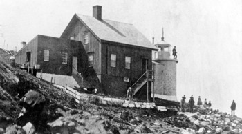
A 20-foot stone tower and accompanying keeper’s house were built for $4,000. The original keeper’s house was in disrepair by 1857. A new wood-frame dwelling was constructed, connected by a covered passageway to the cylindrical brick tower.
Benjamin Eldridge Burgess became keeper in 1867. He was still in charge thirty-seven years later, at the age of 80, when the Boston Globe published an article about him. The article called Burgess “a good man, a good servant of Uncle Sam, and a saver of countless lives.”
This was one of the last lighthouses in Maine to be automated. Under the Maine Lights Program, the lighthouse buildings were transferred to the Town of Vinalhaven in 1998. The station is the residence of Vinalhaven’s town manager.
Vinalhaven can be reached by the Maine State Ferry (207-596-2202, www.maine.gov/mdot/msfs). To reach the lighthouse from the ferry terminal, turn right and follow Main Street to High Street. Turn left onto High Street. Turn right onto North Haven Road. Continue north for about 6.1 miles to a group of mailboxes. Turn left onto unpaved Crockett River Road. After 0.3 miles, turn right onto the second dirt road on the right. Continue another half-mile past a cemetery to a small parking area. The lighthouse grounds are open to the public. Visitors should, of course, respect the privacy of the residents.
The lighthouse can also be viewed from the “Lighthouses Boat Trip” offered by Old Quarry Ocean Adventures (207-367-8977, www.oldquarry.com) of Stonington. Lighthouse cruises offered by the Isle au Haut Company in Stonington (207-367-5193, www.isleauhaut.com) also pass by.
Fascinating Fact 
Vinalhaven is part of a group called the Fox Islands. They were named by explorer Martin Pring after the gray foxes that were common there.