Accessibility: 
Geographic coordinates: 44° 28' 02" N 68° 48' 42" W
Nearest town: Stockton Springs. Located on Cape Jellison, on the west side of the mouth of the Penobscot River.
Established: 1836. Present lighthouse built: 1857. Automated: 1988.
Height of tower: 31 feet. Height of focal plane: 88 feet.
Optic: Fourth-order Fresnel lens.
Characteristic: Fixed white.
Fog signal: One blast every 10 seconds.
This light was established in 1836 to aid vessels bound for Bangor, a leading lumber port. The town of Stockton Springs was also a lumber port and a shipping point for Maine’s potato industry. The first lighthouse was a granite tower. The first keeper was William Clewly, who had sold his land to the government for the station.
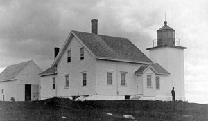
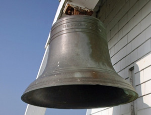
The extant 31-foot square brick lighthouse was built in 1857. A new two-story keeper’s house, attached to the tower, was built the same year. In 1890, a bell tower and a barn were added, and an oil house was built in 1897. All of these buildings are still standing, making Fort Point Light an unusually well-preserved light station. The pyramidal bell tower is one of the few left in New England and is listed on the National Register of Historic Places. The bell, replaced by a foghorn, hangs outside the tower. There are historic photos displayed inside the tower, and it’s sometimes opened to the public in summer.
Larry Baum was the last Coast Guard keeper at the family station. Under the Maine Lights Program coordinated by the Island Institute of Rockland, the lighthouse became the property of the Maine Bureau of Parks and Land in 1998. The lighthouse grounds are now part of 154-acre Fort Point State Park.
Since 1988, the resident “keepers” for the Maine Bureau of Parks and Lands have been Terry and Jeralyn Cole. Terry was the keeper at Fort Point Light back when he was in the Coast Guard in the early 1970s
Fascinating Fact 
The lighthouse gets its name from adjacent Fort Pownall, built by order of Massachusetts Governor Pownall (Maine at that time was part of Massachusetts) in 1759 to guard against the French.
There are signs on Route 1 in Stockton Springs pointing the way to Fort Point State Park and the lighthouse. After turning off Route 1 (a right turn if you’re heading north) onto Main Street, continue for 0.6 miles and then turn right onto Cape Jellison Road. Turn left after 0.9 miles and continue to the entrance to the park on the left. Follow to the parking area on the right, near the fort and lighthouse. For more information on the park, you can call 207-567-3356.