Though perhaps not as well known as deserts such as the Sahara and Kalahari, semiarid regions are intensely studied by environmental scientists, especially on account of the delicate nature of their ecosystems, which are under constant threat from the forces of climate change and human activities.
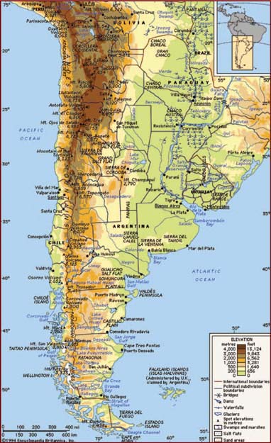
Two great regions of the Western Hemisphere, the Great Plains of North America and Patagonia in South America, have exerted great influence on the economies, history, and culture of the countries where they are located. The Aral Sea is unique in the world as a human-made dry region, once a large inland lake but now shrunk to a fraction of its former size by the diversion of its source rivers for use in agriculture.
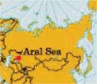
The Aral (Uzbek: Orol) Sea is a once-large saltwater lake straddling the boundary between Kazakhstan to the north and Uzbekistan to the south. The shallow Aral Sea was formerly the world’s fourth largest body of inland water. It nestles in the climatically inhospitable heart of Central Asia, to the east of the Caspian Sea. The Aral Sea is of great interest and increasing concern to scientists because of the remarkable shrinkage of its area and volume that began in the second half of the 20th century. This change is primarily due to the diversion (for purposes of irrigation) of the riverine waters of the Syr Darya and Amu Darya, which discharge into the Aral Sea and are its main sources of inflowing water. The Syr Darya River is the longest river in Central Asia with a length of 1,374 miles (2,212 km). The Amu Darya is shorter at 879 miles (1,415 km) long, but carries more water. Both rivers have been extensively tapped since the 1970s, mostly for irrigating cotton fields. Pollutants such as toxic fertilizers and salt deposits have leached into the rivers’ waters, leaving nearby soil infertile and further degrading the quality of the Aral’s water.
The Aral Sea depression was formed toward the end of the Neogene Period (which lasted from about 23 million to 2.6 million years ago). Later the hollow was partially filled with water—some of which came from the Syr Darya. Toward the end of the Pleistocene Epoch (which occurred about 2,600,000 to 11,700 years ago) or in the early Holocene (after about 11,700 years ago), the depression was inundated for the first time by the Amu Darya, which had temporarily changed its course from the Caspian to the Aral Sea, and the rivers’ combined flow maintained a high water level.
The Aral Sea area is characterized by a desert-continental climate of wide-ranging air temperatures, cold winters, hot summers, and sparse rainfall. The rate of precipitation—an annual average of 100 mm (4 inches) in all—is only a tiny fraction of the lake’s traditional rate of evaporation. The most significant factors affecting the water balance of the Aral Sea are river flow and evaporation, which formerly took out each year about the same amount of water that the rivers brought in. Over the centuries, variations have exceeded 6 metres (20 feet), while annual and seasonal variations of between 3 metres (10 feet) and less than a foot have been recorded.
In 1960 the surface of the Aral Sea lay 53 metres (175 feet) above sea level and covered an area of 68,000 square km (26,300 square miles). The Aral Sea’s greatest extent from north to south was almost 435 km (270 miles), while that from east to west was just over 290 km (180 miles). Although the average depth was a shallow 16 metres (53 feet) or so, it descended to a maximum of 69 metres (226 feet) off the western shore. The sea’s northern shore—high in some places, low in others—was indented by several large bays. The low-lying and irregular eastern shores were interrupted in the north by the huge delta of the Syr Darya and in the south were bordered by a wide tract of shallow water. The equally vast Amu Darya delta lay on the lake’s southern shore, and along the lake’s western periphery extended the almost unbroken eastern edge of the 250-metre- (820-foot-) high Ustyurt Plateau.
From about 1960 the Aral Sea’s water level was systematically and drastically reduced because of the diversion of water from the Amu Darya and Syr Darya rivers for purposes of agricultural irrigation. As the Soviet government converted large acreages of pastures or untilled lands in Uzbekistan, Kazakhstan, Turkmenistan, and elsewhere into irrigated farmlands by using the waters of the Amu Darya and Syr Darya, the amount of water from these rivers that reached the Aral Sea dropped accordingly. By the 1980s, during the summer months, the two great rivers virtually dried up before they reached the lake. The Aral Sea began to quickly shrink because of the evaporation of its now-unreplenished waters.
By 1989 the Aral Sea had receded to form two separate parts, the “Greater Sea” in the south and the “Lesser Sea” in the north, each of which had a salinity almost triple that of the sea in the 1950s. By 1992 the total area of the two parts of the Aral Sea had been reduced to approximately 33,800 square km (13,000 square miles), and the mean surface level had dropped by about 15 metres (50 feet). The governments of the states surrounding the Aral tried to institute policies to encourage less water-intensive agricultural practices in the regions south and east of the lake, thus freeing more of the waters of the Amu Darya and the Syr Darya to flow into the lake and to stabilize its water level. These policies succeeded in reducing water usage somewhat but not to the level necessary to have a significant impact on the amount of water reaching the Aral Sea. In 1994 these same states—Kazakhstan, Kyrgyzstan, Tajikistan, Turkmenistan, and Uzbekistan—established a joint committee to coordinate efforts to save the Aral Sea. The difficulty of coordinating any plan between these competing states, however, has hampered progress.
By the end of the century the Aral had receded into three separate lakes: the Greater Sea had divided into a long, narrow western lake and a larger, broader eastern lake, with the remains of the Lesser Sea to the north. The level of the sea had dropped to 36 metres (125 feet) above sea level, and the water volume was reduced by three-fourths of what it had been in 1960. Almost no water from the Amu Darya and the Syr Darya reached the sea. In the early 21st century the eastern portion of the Aral suffered the most drastic and immediate decline—diminishing by some four-fifths between 2006 and 2009. Although the World Bank funded the construction of a dike that was anticipated to preserve the northern portion of the sea, it was expected that the entirety of the remaining southern portion—both eastern and western lobes—would be lost by 2020.
The rapid shrinkage of the Aral Sea led to numerous environmental problems in the region. By the late 1980s the lake had lost more than half the volume of its water. The salt and mineral content of the lake rose drastically because of this, making the water unfit for drinking purposes and killing off the once-abundant supplies of sturgeon, carp, barbel, roach, and other fishes in the lake. The fishing industry along the Aral Sea was thus virtually destroyed. The ports of Aral in the northeast and Mŭynoq in the south were now many miles from the lake’s shore. A partial depopulation of the areas along the lake’s former shoreline ensued. The contraction of the Aral Sea also made the local climate noticeably harsher, with more extreme winter and summer temperatures.
In the late 1990s an island in the Aral Sea, Vozrozhdenya, became the centre of environmental concern. The Aral Sea derived its name from the Kyrgyz word Aral-denghiz, “Sea of Islands”—an apt designation, as there were more than 1,000 islands of a size of 1 hectare (2.5 acres) or more strewn across its waters. Many of these islands have joined the mainland with the shrinking size of the sea. By 1999 the sea had receded to a level where only 10 km (6 miles) of water were separating Vozrozhdenya Island from the mainland. The increasing accessibility of the island from the mainland was of special concern because Vozrozhdenya had been a testing ground for Soviet biological weapons during the Cold War. In addition to testing done there on such agents as tularemia and bubonic plague, hundreds of tons of live anthrax bacteria were buried on the island in the 1980s. In 1999 still-living anthrax spores were discovered on the site, and scientists feared that when the island was no longer surrounded by water, land vertebrates could carry anthrax to populated areas.
The health costs to people living in the area had already begun to emerge. Hardest hit were the Karakalpaks, who live in the southern portion of the region. Exposed seabeds led to dust storms that blew across the region, carrying a toxic dust contaminated with salt, fertilizer, and pesticides. As a result, health problems occur at unusually high rates—from throat cancers to anemia and kidney diseases—and infant mortality in the region is among the highest in the world.
The Great Plains are a major physiographic province of North America. The Great Plains lie between the Rio Grande in the south and the delta of the Mackenzie River at the Arctic Ocean in the north and between the Interior Lowland and the Canadian Shield on the east and the Rocky Mountains on the west. Their length is some 5,000 km (3,000 miles), their width from 500 to 1,100 km (300 to 700 miles), and their area approximately 2,900,000 square km (1,125,000 square miles), roughly equivalent to one-third of the United States. Parts of 10 states of the United States (Montana, North Dakota, South Dakota, Wyoming, Nebraska, Kansas, Colorado, Oklahoma, Texas, and New Mexico) and the three Prairie Provinces of Canada (Manitoba, Saskatchewan, and Alberta) and portions of the Northwest Territories are within the Great Plains proper. Some writers have used the 100th west meridian as the eastern boundary, but a more precise one is the eastward-facing escarpments—the Balcones Escarpment in the far south and the Missouri Escarpment in the north—that run from Texas to North Dakota, generally somewhat east of the 100th meridian. In the Canadian portion the line dividing the Great Plains from the Canadian Shield runs east of the Red River of the North, cuts through Lake Winnipeg, and then curves northwestward, crossing Lake Athabasca, Great Slave Lake, and Great Bear Lake; in the far north, the plains reach the Arctic Ocean in a narrow strip just west of the Mackenzie delta.
The Great Plains are a vast high plateau of semiarid grassland. Their altitude at the base of the Rockies in the United States is between 1,500 and 1,800 metres (5,000 and 6,000 feet) above sea level; this decreases to 450 metres (1,500 feet) at their eastern boundary. The altitudes of the Canadian portion are lower, and near the Arctic Ocean the surface is only slightly above sea level. Some sections, such as the Llano Estacado (Staked Plains) in western Texas and eastern New Mexico, are extremely flat; elsewhere, tree-covered mountains—the Black Hills of South Dakota and the Bear Paw, Big Snowy, and Judith mountains of Montana—rise 450 to 600 metres (1,500 to 2,000 feet) above the general level of the plains. In general, this landscape is not the flat, featureless plain that most envision it to be; low hills and incised stream valleys are commonplace.
In the United States the Great Plains are drained by the Missouri River and its tributaries (the Yellowstone, Platte, and Kansas) and the Red, Rio Grande, and Arkansas rivers, which flow eastward from the Rockies in broad, steep-sided, shallow valleys. The Red River of the North, which forms the border between North Dakota and Minnesota, drains north into Canada. In Canada the Saskatchewan River and its tributaries constitute the main drainage system.
Harney Peak (centre) towering over Sylvan Lake in Custer State Park, Black Hills region of South Dakota. © Craig Blacklock/Blacklock Nature Photography
The soil groups of the Great Plains are correlated with rainfall and natural grass cover. In the more humid region with taller, heavier grass cover, deep, black soils (mollisols) with much organic matter developed. Sections with less moisture have lighter, shallower soils with less organic matter, while in the most arid regions the soils are even thinner, lighter in colour, and less organic in composition. Most of the soils have an accumulation of carbonates in their lower horizons, translocated there by infiltrating water. Advancing from east to west across the Great Plains, the climate gets progressively drier and, hence, the depth of carbonates decreases.
The Great Plains have a continental climate. Over much of their expanse, cold winters and warm summers prevail, with low precipitation and humidity, much wind, and sudden changes in temperature. The major source of moisture is the Gulf of Mexico, and the amount falls off both to the north and west. Thus, the southern plains have 375 to 625 mm (15 to 25 inches) of rain annually, the northern plains 300 to 375 mm (12 to 15 inches), the eastern margin in Nebraska 625 mm (24.6 inches), and the western margin in Montana less than 375 mm (14.7 inches). More rainfall occurs in summer than in winter, except in some of the northwestern parts of the Great Plains. The southern parts of the Canadian Great Plains receive 250 to 500 mm (10 to 20 inches) and have a growing season of 70 to 110 days. The growing season averages 240 days in Texas and 120 days at the U.S.-Canadian boundary. A distinctive winter phenomenon of the western Great Plains is the chinook, a warm, dry wind that blows down the eastern slope of the Rocky Mountains and can raise temperatures by as much as 17 to 22 °C (30 to 40 °F) in a short period.
Natural vegetation in the Great Plains is dominated by grasses—tallgrass and medium grass prairie in the east and shortgrass and bunchgrass steppes in the west. These grasslands include forbs and larger plants such as the yucca and the prickly pear cactus in marginal areas, as well as shrubs and some small trees such as the mesquite and the sagebrush. Much of the natural grass cover, however, has been removed to create agricultural land or is heavily overgrazed, allowing for an increase in less-palatable species such as the cactus. Gallery (riparian) forests are found along the rivers and include hardy xerophytic (drought-tolerant) trees such as box elder and cottonwood. Coniferous evergreens (primarily Ponderosa pine) dominate the mountain islands, such as the Black Hills. Between Edmonton, Alta., and Winnipeg, Man., a transition zone trending northwest-southeast and known as the “Parklands” is found, where the grasslands gradually give way to forest; and north of 54° N latitude coniferous forests dominate the vegetation.
Before European settlement, the Great Plains were the home of immense herds of grazing mammals: the buffalo (bison) and the pronghorn. The buffalo were nearly eliminated, but the pronghorn continued to thrive. Other grassland-adapted animals that thrive together with agriculture include prairie dogs, coyotes, prairie chickens, and rattlesnakes. In the northern coniferous forests are found moose, woodland caribou, Canada lynx, and timber wolves. The region is not without its share of insect pests, such as the locust and the tiny chigger.
European knowledge of the Great Plains began with the expedition of the Spanish explorer Francisco Vázquez de Coronado in 1539–41. American interest in the region was sparked by the Louisiana Purchase (1803), which gave rise to the great Lewis and Clark Expedition in 1804–06. Two subsequent expeditions are of note: the first, led by Zebulon Pike (1805–07), explored the Arkansas and Red rivers; and the second, led by Stephen Long (1820), concentrated on the Platte and Arkansas river basins and caused Long to characterize the region as the “Great American Desert.” Fur trappers and then settlers traveling through the region on the Oregon, Mormon, and Santa Fe trails completed the basic knowledge of the plains.
Study of the Great Plains in the 20th century concentrated on their agricultural and mineral potential, as well as on their natural history. Since World War II more emphasis has been placed on ecological studies of the soils, groundwater, and effects of the use of agricultural chemicals. Research also has been undertaken on the effects of rural depopulation and on the impact the region’s natural grass cover—particularly its restoration—may have on global climatic conditions, including the greenhouse effect.
Patagonia is a semiarid scrub plateau that covers nearly all of the southern portion of mainland Argentina. With an area of about 673,000 square km (260,000 square miles), it constitutes a vast area of steppe and desert that extends south from latitude 37° to 51° S. It is bounded, approximately, by the Patagonian Andes to the west, the Colorado River to the north (except where the region extends north of the river into the Andean borderlands), the Atlantic Ocean to the east, and the Strait of Magellan to the south; the region south of the strait—Tierra del Fuego, which is divided between Argentina and Chile—also is often included in Patagonia.
The name Patagonia is said to be derived from Patagones, as the Tehuelche Indians, the region’s original inhabitants, were called by 16th-century Spanish explorers. According to one account, Ferdinand Magellan, the Portuguese navigator who led the first European expedition into the area, coined that name because the appearance of the Tehuelche reminded him of Patagon, a dog-headed monster in the 16th-century Spanish romance Amadís of Gaul.
Desert and semidesert cover the Patagonian tableland that extends from the Andes to the Atlantic Ocean. The general aspect of this tableland is one of vast steppelike (i.e., virtually treeless) plains, rising in terrace fashion from high coastal cliffs to the foot of the Andes; but the true aspect of the plains is by no means as simple as such a general description would imply. The land along the Negro River rises in a series of fairly level terraces from about 90 metres (300 feet) at the coast to about 400 metres (1,300 feet) at the junction of the Limay and Neuquén rivers and 900 metres (3,000 feet) at the base of the Andes. The tableland region rises to an altitude of 1,500 metres (5,000 feet).
South of the Negro River, the plains are much more irregular. Volcanic eruptions occurred in this area until fairly recent times, and basaltic sheets covered the tableland east of Lakes Buenos Aires and Pueyrredón. Near the Chico and Santa Cruz rivers, the plains have spread to within about 80 km (50 miles) of the coast and reach almost to the coast south of the Coig and Gallegos rivers. In places, basaltic massifs (mountain masses) are the salient features of the landscape.
The coast consists largely of high cliffs separated from the sea by a narrow coastal plain. Thus, the plateaus are formed of horizontal strata, some of sedimentary rocks and others of lava flows. Areas of hilly land, composed of resistant crystalline rocks, stand above the plateaus.
The deep, wide valleys bordered by high cliffs that cut the tablelands from west to east are all beds of former rivers that flowed from the Andes to the Atlantic; only a few now carry permanent streams of Andean origin (the Colorado, Negro, Chubut, Senguerr, Chico, and Santa Cruz rivers). Most of the valleys either have intermittent streams—such as the Shehuen, Coig, and Gallegos rivers, which have their sources east of the Andes—or contain streams like the Deseado River, which completely dry up along all or part of their courses and are so altered by the combined effect of wind and sand as to afford little surface evidence of the rivers that once flowed in them. Still other streams, such as the Perdido, terminate in basins containing salt flats or salt ponds. The canyon bottoms consist mostly of deep beds of coarse alluvial sands and gravels, which act as groundwater reservoirs to supplement the scanty surface water.
The line of contact between the Patagonian tableland and the Patagonian Andes is marked by a chain of lakes found in glacier troughs or cirques that are dammed downslope by moraines and other glacial landforms consisting of unconsolidated and unsorted till. From Lake Nahuel Huapí northward, the lakes—except for Lake Lácar—drain to the Atlantic. South of Lake Nahuel Huapí, however, all the lakes except Viedma and Argentino drain to the Pacific through deep canyons that have been cut from west to east across the cordillera by headward erosion.
The best soils in Patagonia are found north of the Negro River, especially where they are formed from volcanic rock. Proceeding south, the soils become increasingly arid and stony, and broad expanses of stream-rounded pebbles, called grava patagónica, often are found on level ground.
Patagonia is influenced by the South Pacific westerly air current, which brings humid winds from the ocean to the continent. These winds, however, lose their humidity (through cooling and condensation) as they blow over the west coast of South America and over the Andes, and they are dry when they reach Patagonia. Patagonia can be divided into two main climatic zones—northern and southern—by a line drawn from the Andes at about latitude 39° S to a point just south of the Valdés Peninsula, at about 43° S.
The northern zone is semiarid, with annual mean temperatures between about 12 and 20 °C (54 and 68 °F); recorded maximum temperatures vary from about 41 to 45 °C (106 to 113 °F), and minimum temperatures from −11 to −5 °C (12 to 23 °F). Sunshine, minimal along the coast, is most plentiful inland to the northwest. Annual rainfall amounts vary from about 90 to 430 mm (3.5 to 17 inches). The prevailing winds, from the southwest, are dry, cold, and strong.
The climate of the southern zone is sharply distinct from the humid conditions of the Andean cordillera to the west. In the northern part of the zone, Atlantic influences are practically nonexistent—probably because of the relatively high elevations of the coastal region, which reach 270 to 540 metres (900 to 1,800 feet) around San Jorge Gulf—although cold Pacific winds from the west and the cold Falkland Current off the Atlantic coast do have some effect. In the southern part, which becomes increasingly peninsular with higher latitude, the Atlantic exerts some influence. The zone has a cold, dry climate, with temperatures that are higher along the coast than they are inland and with strong west winds. Mean annual temperatures range from 4 to 13 °C (40 to 55 °F), with the maximum temperature reaching about 34 °C (93 °F) and minimum temperatures between −9 and −33 °C (16 and −27 °F). Heavy snows fall in winter, and frosts can occur throughout the year; spring and autumn provide only short transitions between summer and winter. Average annual precipitation (rain and snow) ranges between about 125 and 200 mm (5 and 8 inches), though as much as 475 mm (19 inches) has been recorded. Less precipitation falls in the arid central areas, which also receive more sunshine than the coast or the Andean cordillera.
The long, narrow strip of Patagonia’s western border supports vegetation like that found in the adjacent cordillera, primarily deciduous and coniferous forests. The vast tableland region is divided into northern and southern zones, each of which has its own characteristic vegetation.
The larger northern steppe zone extends south to about latitude 46° S. In the north is found monte vegetation—xerophytic (drought-tolerant) scrub forests—which gives way farther south to open bushland of widely spaced thickets between about 1 and 2 metres (3 and 7 feet) high. Grasses flourish in the sandy areas, while halophytic (salt-tolerant) grasses and shrubs predominate in the salt flats. The southern, more arid, zone extends south of 46° S. The vegetation is low and considerably more sparse and needs almost no water.
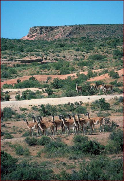
Among the Patagonian birds are herons and other waders; predators such as the shielded eagle, the sparrow hawk, and the chimango (or beetle eater); and the almost extinct rhea (nandu). The typical marsupial of the region is the comadreja (a member of the weasel family). Species of bats include a long-eared variety. Armadillos, pichis (small armadillos), foxes, ferrets, skunks, mountain cats, and pumas are to be found, as are the Patagonian cavy (or mara) and different kinds of burrowing rodents, such as the vizcacha and the tuco-tuco. Of the larger mammals, the most noteworthy is the guanaco, a camelid, which has been hunted almost to extinction.
Patagonia has a number of species of poisonous snakes, as well as tortoises and a variety of lizards. Among the arthropods and arachnids are vinchucas (winged bugs), bloodsucker insects (transmitters of American trypanosomiasis, or Chagas’ disease), scorpions, and several kinds of spiders, including one endemic genus called Mecysmanchenius. The rivers and lakes are naturally poor in fish, but some have been stocked with salmon and trout. Marine fish, however, as well as crustaceans and mollusks are plentiful off the coast.
From the Altiplano of South America to the Rajasthan Steppe of South Asia, many semiarid regions support an agricultural or pastoral way of life or are exploited for their minerals.
The Altiplano (English: High Plateau), also called the Puna, is a region of southeastern Peru and western Bolivia. The Altiplano originates northwest of Lake Titicaca in southern Peru and extends about 1,000 km (600 miles) southeast to the southwestern corner of Bolivia. It is a series of intermontane basins lying at about 3,600 metres (12,000 feet) above sea level. Lake Titicaca occupies the northernmost basin; to the south are Lake Poopó and the Coipasa and Uyuni salt flats. The basins are separated by spurs reaching eastward from the Cordillera Occidental of the Andes Mountains. On the eastern side of the Altiplano, however, there is a continuous passageway of gentle gradient extending southward across Bolivia. The Cordillera Oriental of the Andes forms the eastern boundary of the Altiplano.
The dominant vegetation consists of grass and shrubs. The region’s wildlife originally included the alpaca and the llama, both of which are now bred for wool and serve as pack animals. The southern half of the Altiplano falls within a zone of deficient moisture, while the northern half receives rainfall adequate for the cultivation of crops without irrigation.
Temperatures around the shores of Lake Titicaca are moderate, and corn (maize) and wheat can be grown there to an elevation of 3,900 metres (12,800 feet). The basin, now the location of urban centres such as Puno and Juliaca, Peru, has been the core of a relatively dense population since ancient times. La Paz, the chief political and commercial city of Bolivia in the Altiplano, is located not far southeast of Lake Titicaca, at the bottom of a spectacular chasm 400 metres (1,400 feet) below the surface of the Altiplano but still 3,631 metres (11,909 feet) above sea level.
The southern half of the Altiplano is much less hospitable to settlement than the north, although its desolate expanses of desert yield important mineral resources including copper, silver, tungsten, and tin. One of Bolivia’s main railway lines runs along the eastern edge of the Altiplano, from the southern edge of the Titicaca Basin southward to Oruro, Bolivia, where the line forms two branches, one extending to the tin mines of Unicia, Bolivia, in the Cordillera Oriental, and one to the basin of Cochabamba, Bolivia, on the lower eastern slopes.
The Kulunda Steppe (Russian: Kulundinskaya Ravnina; Kazak: Qulyndy Zhazyghy) is a lowland constituting the extreme southern extension of the West Siberian Plain. Most of the steppe lies in Russia, but its western part extends into Kazakhstan. Roughly triangular in shape, with its point to the south, it covers an area of approximately 100,000 square km (39,000 square miles). With a poor drainage pattern because of low relative relief and meagre rainfall, the steppe has numerous lakes, mostly salt; Lake Kulunda is the largest. Glauber’s salt (a sodium sulfate compound used in dyes and medicines) and soda are extracted from the lakes. The city of Pavlodar lies at the steppe’s western margin.
The Llano Estacado (English: Staked Plains), is a portion of the High Plains of the United States, along the Texas–New Mexico border. It covers an area of about 78,000 square km (30,000 square miles) and is bounded by the Canadian River valley (north), the “break of the plains” (east), the Edwards Plateau (south), and the Mescalero Ridge overlooking the Pecos River (west). Strikingly level in appearance and averaging 900–1,200 metres (3,000–4,000 feet) above sea level, the semiarid plain is occasionally broken by localized water-retaining depressions. Its potentially fertile soils, though handicapped by meagre rainfall, high evaporation rates, and periodic droughts, support grazing, dry-land farming of wheat and grain sorghums, and irrigated cotton production. Production of petroleum and natural gas is also important. Lubbock and Amarillo, Tex., are the most important cities in the region; but a less than salubrious climate and isolation combine to restrict population growth.
The Mongolian Plateau is an extensive northeastern highland region of the great plateau of Central Asia, covering an area of approximately 2,600,000 square km (1,000,000 square miles) in east-central Asia. It is divided politically and geographically by the Gobi (desert) into the independent state of Mongolia (also called Outer Mongolia) in the north and the Inner Mongolia Autonomous Region of China in the south. Surrounding the plateau and bordering it are the Altai, Tannu-Ola (Tagnïn Nuruu), and Sayan mountains to the northwest, the Hentiyn Mountains to the north, the Greater Khingan Range to the east, the Nan Mountains to the south, and the Tarim and Dzungarian basins of the Uighur Autonomous Region of Sinkiang, China, to the west. This high tableland, which is also regarded sometimes as a large interior drainage basin between the bordering mountain ranges, is drained by the Dzavhan, Selenga (Selenge), and Kerulen rivers. The plateau, which includes the Gobi together with areas of dry short-grass steppe, ranges in elevation from 900 to 1,500 metres (3,000 to 5,000 feet) above sea level. The highest point is Mönh Hayrhan Peak (4,362 metres [14,311 feet]) in the Mongolian Altai Mountains. The dry continental climate is characterized by an annual rainfall of about 200 mm (8 inches), and the mean temperatures of the warmest and coldest months vary over an enormous range. At Ulaanbaatar, for example, the average January temperature is −26 °C (−15 °F), whereas the average July temperature is 17 °C (63 °F).
The part of the plateau in independent (Outer) Mongolia is inhabited mostly by Mongolians; Kazaks constitute the largest minority group. The Han (Chinese), who are mostly agriculturists, constitute about four-fifths of the population of Inner Mongolia. Traditionally the people have been nomadic and chiefly engaged in raising sheep and goats, but extensive livestock farms were developed in the 20th century. Although the harsh climate restricts agriculture, wheat, oats, and other grains and vegetables are grown on the plateau. In irrigated areas of Inner Mongolia, sugar beets and oilseeds are raised.
Coal is mined near Saynshand in Mongolia, and coal and iron ore are mined in the vicinity of Pao-t’ou (Baotou) in Inner Mongolia. Copper, molybdenum, fluorite, uranium, gold, and silver are other important minerals. The Trans-Mongolian Railway (completed 1955) links the capital of Mongolia, Ulaanbaatar, near the northern edge of the plateau, with Ulan-Ude in the republic of Buryatia in Russia and with Erh-lien-hao-t’e (Erenhot), northwest of Beijing in China. Although roads cross the region, the plateau remains relatively isolated and economically underdeveloped.
The Pampas (Spanish: La Pampa) are vast plains extending westward across central Argentina from the Atlantic coast to the Andean foothills, bounded by the Gran Chaco (north) and Patagonia (south). The name comes from a Quechua Indian word meaning “flat surface.” The Pampas have a gradual downward slope from northwest to southeast, from approximately 500 metres (1,640 feet) above sea level at Mendoza to 20 metres (66 feet) at Buenos Aires. Apart from a few sierras in the northwest and south, most of the region appears perfectly flat. Several smaller plains in other parts of South America, such as the desert of northern Chile, are also referred to by the term Pampas.
The Argentine Pampas covers an area of approximately 760,000 square km (295,000 square miles) and is divided into two distinct zones. The dry zone in the west, which includes most of La Pampa province, is largely barren, with great saline areas, brackish streams, and sandy deserts. The humid zone in the east, a much smaller area that includes part of Buenos Aires province, is temperate and well-watered and is the economic heart of the nation and the country’s most populated area. The soil consists chiefly of fine sand, clay, and silt washed down toward the Atlantic by the great rivers or blown in dust storms from the west. Cool winds from the south periodically meet warm air from the tropical north, creating violent gales accompanied by heavy rain in the neighbourhood of Buenos Aires. These storms are known as pamperos. Characteristic animals of the Pampas include foxes, skunks, small herds of guanaco, viscachas, bush dogs, and many bird species related to the sparrows, hawks, and waterfowl of the North American prairies.
The region has been transformed since the middle of the 19th century. The Spaniards had introduced cattle and horses but had made no attempt toward land development. The animals were rounded up by a kind of cowboy called a gaucho. Gauchos were celebrated for their horsemanship, hardiness, and lawlessness. After liberation from Spain (1816) and the annihilation of the Indians who roamed the plains, landowners began to employ immigrants (chiefly Italians) to cultivate their estancias (ranches), sowing alfalfa for fodder, corn (maize), and finer pastures. They fenced their lands and imported pedigreed sheep and cattle from Great Britain. Railways were built across the Pampas, the gauchos gradually became peons (labourers), and horses were replaced by tractors. The southeastern area between Mar del Plata and Tandil, being relatively cool and containing much swampy land, was devoted to the breeding of high-grade sheep and cattle, while the western belt (from Bahía Blanca to Santa Fe) was cultivated principally for alfalfa and wheat. Around Rosario, corn (maize) and flax are the chief crops, and some livestock is raised. The vicinity of Buenos Aires has been developed to supply the capital with vegetables, fruit, and milk. Since the late 20th century some parts of the Pampas have become noted grape-growing regions, particularly the region around Mendoza, which produces more than half the wines of South America.
The Pampas served as background in Argentina’s gaucho literature, including such notable works as José Hernández’s El gaucho Martín Fierro (1872) and Ricardo Güiraldes’s Don Segundo Sombra (1926), and also as the theme for a great deal of Argentina’s musical folklore.
The Plateau of Tibet (Chinese: Qingzang Gaoyuan, or Ch’ing-tsang Kao-yuan), also called the Tibetan Highlands or the Qinghai-Tibet Plateau, is a vast, high plateau of southwestern China. It encompasses all of the Tibet Autonomous Region and much of Qinghai province and extends into western Sichuan province and southern Uigur Autonomous Region of Xinjiang. The region lies between the Kunlun Mountains and its associated ranges to the north and the Himalayas and Karakoram Range to the south and southwest, respectively; it extends eastward to the Daxue Mountains and, farther south, the northern and central portions of the Hengduan Mountains. The plateau, which has an area of about 2,500,000 square km (965,000 square miles), is a region of tangled mountains and uplands that are generally above 4,000 to 5,000 metres (13,000 to 15,000 feet) in elevation. Mount Everest (Qomolangma Feng), rising 8,850 metres (29,035 feet) above sea level on the China-Nepal border, is the world’s highest peak.
The northern section of the plateau, called Qiangtang, is dotted with many brackish lakes; its southern section contains the headwaters of the upper Indus and Brahmaputra rivers. Other rivers that have their headwaters in the highlands are the Yangtze River (Chang Jiang), the Huang He (Yellow River), the Mekong, the Salween, and the Tarim. Grasslands are used for pasturage, and barley is grown on the plateau; forests grow on the slopes of valleys, particularly in the south. The most extensive farming in Tibet takes place on the fertile plains of the Brahmaputra River and its tributaries. Lhasa, the capital of Tibet, is the plateau’s major centre of population, economic activity, culture, and air and land transportation.
The Rajasthan Steppe is a desert in west-central Rajasthan state, northwestern India. It has an area of about 142,000 square km (54,800 square miles). The region was ruled successively in ancient times by the Mauryas, Guptas, and Gurjar Pratiharas. Later it was ruled by Rajput dynasties before coming under Mughal control.
Near Jodhpur is bedrock similar to that of the Vindhya Range; farther south there are Malani volcanic and Jalore Siwana granitic rocks. The region slopes downward from the Aravalli Range in the northeast to the Luni River basin in the southeast, where rocks above the sandy surface bear evidence of wind erosion. The Rajasthan Steppe has also been subject to extensive gullying. Large areas are covered with thorny scrub, acacia, and palm trees. The Luni is the only major river; the inland drainage pattern has created a number of salt lakes, such as the Didwana, Kuchman, Degna, and Sambhar. The desert soils contain a high percentage of soluble salts.
Livestock (cattle, sheep, goats, and camels) raising and agriculture are economically important; cereal grains, pulses (legumes), oilseeds, cotton, and sugarcane are grown. The region suffers occasionally from severe droughts and swarms of locusts. It is rich in mineral resources (especially marble and salt), and gypsum, silver ore, and feldspar are mined; there is a sulfur plant at Sambhar Salt Lake. Rugs and woolen textiles, sugar, cement, pesticides, and dyes are produced. Jodhpur, Ganganagar, Churu, and Jhunjhunu are the important towns and cities in the region.
Far from being lifeless wastelands, Earth’s arid and semiarid regions are home to many unique organisms that have adapted to harsh conditions. Even in the hottest and driest deserts living things make use of the available moisture, and all desert organisms possess structures or behaviours that inhibit the evaporation of water from their tissues. Some plants make the most of brief periods of precipitation by taking up and storing large amounts of water, whereas other plants use long roots to tap groundwater sources. Animals also possess adaptations for dealing with hot and dry conditions. Some animals, such as the camels of Africa and Eurasia, store relatively large volumes of water within their bodies. Many insect species ride out the harshest conditions by entering a torpid state, and birds tend to migrate from the driest areas to areas of recent rainfall.
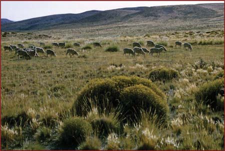
Semiarid scrublands and steppes receive more precipitation than deserts, with rain or snow falling throughout the course of a season. Consequently, vegetation in these regions grows taller than in deserts, but lush stands of trees are rare. Scrublands contain a wide variety of shrubby plants. The wider plant diversity and relatively mild environmental conditions of these regions promote a greater animal diversity. Since scrublands and steppes occur over a wide range of environmental conditions, the ecological structure of these ecosystems varies from continent to continent.
In terms of primary productivity, deserts are the least productive ecosystems. Although scrublands and steppes can be many times more productive than deserts, they are ecosystems that carry the greatest risk of being transformed into deserts through agriculture, grazing, irrigation, and other human activities and climatic change. Along with reduced biological productivity, such desertification carries a number of environmental and economic consequences. The process of desertification can be mitigated, however, by employing measures that conserve soil, water, and biological resources. These include crop rotation, rotational grazing, and planting cover crops to protect the soil from erosion by wind and rain.