14 Spruce Flats Falls
Although it’s among the most scenic waterfalls in the park, Spruce Flats Falls is relatively unknown compared to the more popular falls such as Laurel Falls and Grotto Falls. The waterfall consists of several drops, with the main one about 40 feet high. There is another section above what you can see from the trail, but there is no good vantage point from which to view it safely. The hike may not be as well known or publicized as many others in the park, but it’s no secret either. If you’re after photos and you don’t want people in them, you need to be here early in the morning.
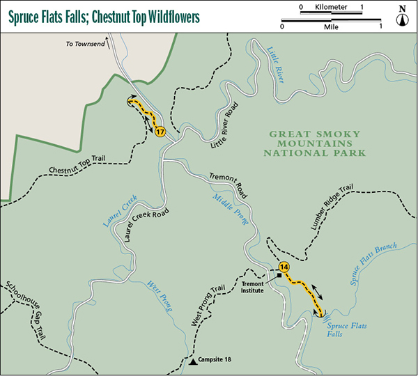
Start: Parking area for the office of Great Smoky Mountains Institute at Tremont
Distance: 2.0 miles out and back
Hiking time: About 1.5 hours—day hike
Difficulty: Moderate
Trail surface: Dirt, rocks, and roots
Other trail users: Hikers only
Maps: Wear Cove USGS quad; Trails Illustrated #229 Great Smoky Mountains; Trails Illustrated #316 Cades Cove Elkmont
Other: The office for Great Smoky Mountains Institute at Tremont has several paved parking spots, but they can fill up quickly during the summer and fall busy season. If the office is open, you can obtain information and purchase park literature. The office has restrooms.
Finding the trailhead: The trail begins from Great Smoky Mountains Institute at Tremont, an environmental-education facility in the Tremont section of the park. To reach the institute, head southwest from the Townsend Y (junction of Little River Road and TN 73) toward Cades Cove. At 0.2 mile from the Y, Tremont Road turns to the left. Follow this road 2.0 miles to the institute, on the left. Turn into the complex, crossing over Middle Prong of Little River, and park at the office, the first building on the left. GPS: N35 38.486' / W83 41.371'
The Hike
The first part of this hike is a little confusing as it winds its way around the complex of buildings for Great Smoky Mountains Institute at Tremont. At the parking area look for the gravel road heading uphill, away from the office. The road is to the left of the paved road leading into the institute complex. Two hundred feet up the gravel road is the dormitory building. Walk to the left of the building to Lumber Ridge trailhead at the edge of the woods. Hike 100 feet on Lumber Ridge Trail and turn right on Buckeye Trail. Buckeye Trail passes behind the institute complex and in about 0.2 mile comes to a fork. A right turn at the fork goes downhill to the institute. You want to take the left fork, heading uphill. After a few yards turn left and follow the switchback to keep from bumping into the water tank. At the second switchback turn right and continue heading uphill. You’ll soon gain the ridge and hike the rest of the way on a poorly graded, rocky, and rooty path. The path descends steeply on its final approach to the falls.
If you make this hike in winter or early spring when the leaves are off the trees, you’ll catch glimpses of Middle Prong below the trail and the gravel Tremont road running beside it. When you get to the falls, you may be surprised to discover that the waterfall is only a few hundred feet from the road. However, the road is on the other side of Middle Prong, which has no footbridge. The river is impossible to rock-hop and difficult—potentially dangerous—to wade.
Miles and Directions
0.0Start on the gravel road leading uphill from the parking area, away from Middle Prong. Walk through the yard to the left of the dormitory and then hike 100 feet on the Lumber Ridge Trail, which is obvious.
0.1Take Buckeye Trail, which turns to the right from Lumber Ridge Trail.
0.3Trail forks, with the right fork leading downhill to the institute complex. Take the left fork, heading uphill.
1.0Arrive at Spruce Flats Falls. Return the way you came.
2.0Arrive back at trailhead.

Spruce Flats Falls.