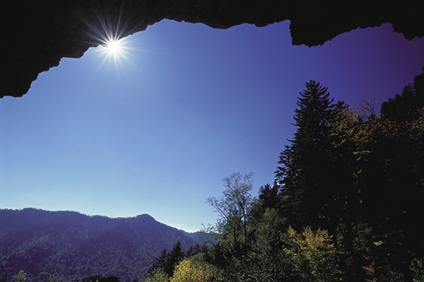
View from underneath Alum Cave Bluffs.
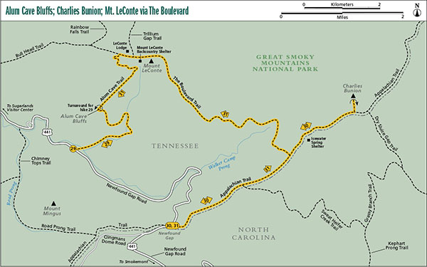
29 Alum Cave Bluffs
It doesn’t get much better than this! Every able person who visits the Smokies is encouraged to make this hike at least once, even if you can’t stand a crowd. If continuing the 2.7 miles from the bluffs to Mount LeConte, this hike would rank high among the best in the park. Even if you stop at the bluffs and backtrack as outlined in this hike, it’s still hard to beat. Of course, there always seems to be a downside. Any day between spring and fall and on weekends during the winter, you can expect to encounter a few billion people on this hike.
Start: Alum Cave trailhead on Newfound Gap Road
Distance: 4.6 miles out and back
Hiking time: About 3 hours—day hike
Difficulty: Moderate, with some short steep sections
Trail surface: Boot-packed trail covered in rocks and roots
Other trail users: Hikers only
Maps: Mount LeConte USGS quad; Trails Illustrated #229 Great Smoky Mountains; Trails Illustrated #317 Clingmans Dome Cataloochee; Trails Illustrated #316 Cades Cove Elkmont
Other: Even though Alum Cave trailhead has more parking places than most other trails in the park, it also fills up faster than most. Show up at noon and you’ll be looking for a spot along the road, some distance from the trailhead. Pit toilets are located at the northern parking area.
Finding the trailhead: On Newfound Gap Road, drive 4.2 miles north of Newfound Gap or 8.5 miles south of Sugarlands Visitor Center. There are two large parking lots on the north side of the road. GPS: N35 37.757' / W83 27.077'
The Hike
An obvious path begins from the east corner of the northern (lower) parking area and from the west corner of the southern (upper) parking area. In a few yards you cross Walker Camp Prong and a short distance farther Alum Cave Creek, both on sturdy bridges. Now you hike on a gentle uphill course alongside the creek and through an old-growth forest. Some of the big hemlocks are still living as of early 2012. (See the sidebar for Hike 36.) The creek bed looks different from most other creeks in the Smokies, and it is. The steep slopes of the Alum Cave Creek drainage make it especially prone to flooding, and the regular torrents keep the streambed scoured clean of moss, ferns, and the usual undergrowth seen along other Smoky Mountain waterways.
After making a few crossings of Alum Cave Creek on sturdy foot logs, you cross Styx Branch a couple of times on foot logs, probably not realizing that Alum Cave Creek had forked off eastward toward the slopes of Anakeesta Knob. At mile 1.4 you cross Styx Branch just below the entrance into Arch Rock, one of the most interesting geological features in the park. The trail climbs through an opening, an “arch” in the Anakeesta Formation. It’s not an arch like those in Arches National Park or those in the valley and ridge provinces of Tennessee and Kentucky. In simplistic terms, those arches formed by erosion from running water. Here, in the Anakeesta Formation, holes in the rock are likely caused from the expansion and crumbling caused by millions of years of freezing and thawing.
View from underneath Alum Cave Bluffs.
Beyond Arch Rock you cross Styx Branch for the final time on a foot log and then swing around a broad ridge to cross another stream. Just before the trail makes a sharp right turn to head up the drainage for the creek, look to the left to see a large yellow birch tree with several other species growing out of its trunk. There’s a rhododendron, a mountain laurel, some small spruces, and a good-size birch growing as a separate tree.
The trail climbs steeply now, and soon you get a profile view of Little Duck Hawk Ridge. Farther up, at an especially scenic vista called Inspiration Point, you get another good view of the ridge. See if you can find both arches in the ridge. In summer one of them may be hard to spot.
From Inspiration Point, you have a short ascent to the bluffs. It’s not a cave, as the name suggests, but rather an overhanging rock ledge. However, this isn’t your average rock overhang. Andy Griffith Show fans may recall a popular line of Barney’s when they see the bluff for the first time. “It’s big, really big.” It’s geologically unique, too. The bluffs create a very dry environment below the overhang, which is responsible for the thick, flour-like powder you walk through. Several very rare minerals have been discovered here, some not known to occur anywhere else in the world. What isn’t here, though, is a lot of alum. In pre-park days several attempts were made to mine the bluffs for various minerals. The full extent of those mining operations isn’t known, but none of them had any significant success.
The bluffs mark the end of this hike, but Alum Cave Trail continues 2.7 miles to Mount LeConte. See the options below if choosing to continue.
Miles and Directions
0.0Start from the north side of the parking area at the trail sign.
1.4Hike through Arch Rock.
2.3Arrive at Alum Cave Bluffs. Return the way you came.
4.6Arrive back at trailhead.
Options: Many people hike Alum Cave Trail all the way to Mount LeConte and back as a day hike, including a lot of overweight and out-of-shape people huffing and puffing up the trail. There seems to be a mystique about having “made it” to LeConte. Here are a couple of options that allow you to see LeConte’s summit without backtracking. Arrange for a shuttle and start at Newfound Gap, returning along Alum Cave Trail (see Hike 31), or have the shuttle take you to the Grotto Falls trailhead and hike up Trillium Gap Trail to the summit and return on Alum Cave Trail. Hike 35 outlines a third route to Mount LeConte via Rainbow Falls Trail and a return by Bull Head Trail.
Before hiking to the summit, be sure to read “Hiking to Mount LeConte” at the beginning of the Northeast section.