Mount Cammerer Lookout.
45 Mount Cammerer
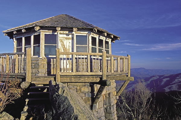
This hike provides the shortest route to the Mount Cammerer Lookout on the rocky summit of Mount Cammerer. The Civilian Conservation Corps built the fire lookout in the 1930s, using the same design as the lookouts on the treeless and rocky mountains of the western states. After falling in disrepair the lookout was restored in 1995 and it is now open for hikers to enjoy, although it is again in need of some repair. The panoramic view from the lookout is spectacular at any time, but if you can make this hike in October when the autumn foliage peaks, you’ll have a hard time pulling yourself away.
(See map for Hike 44: Cosby Nature Trail.)
Start: Low Gap trailhead at the entrance to Cosby Campground
Distance: 11.2 miles out and back
Hiking time: About 7 hours—day hike
Difficulty: Strenuous, due to steep grade
Trail surface: Rocks, roots, and a little dirt
Best seasons: Spring for the wildflowers, Oct for autumn foliage
Other trail users: Equestrians
Maps: Hartford and Luftee Knob USGS quads; Trails Illustrated #229 Great Smoky Mountains; Trails Illustrated #317 Clingmans Dome Cataloochee
Other: The hiker parking lot is plenty large enough most of the time. If it’s full, picnic area parking is right behind it. Restrooms are available at the picnic area.
Finding the trailhead: From the US 321 and TN 32 junction in Cosby, drive 1.2 miles and turn right at the sign for Cosby Campground. Follow this road 2.1 miles to the campground registration building. Drive past the building and turn left to loop back to the hiker parking area. Low Gap Trail starts on the south end of the parking area. GPS: N35 45.353' / W83 12.496'
The Hike
Low Gap Trail begins from the hiker parking area and soon passes behind the campground amphitheater and the trailhead for Cosby Nature Trail. Pay attention to the trail signs through here, because a number of paths lead off from the main trail. At 0.4 mile you come to what looks like an old traffic turnaround. A right turn here takes you over a ford of Cosby Creek and to the campground. Don’t turn right; go to the left for a few yards to the junction with Lower Mount Cammerer Trail. Turn right (south) at this junction to stay on Low Gap Trail.
At 0.8 mile you come to a T junction, with the path on the right leading back to the campground. You want to go to the left and follow Cosby Creek upstream. The forest to this point is very scenic, with many large trees and a carpet of spring wildflowers. As of early 2012, even some of the eastern hemlocks seem to be doing OK here (see the sidebar for Hike 36).
Mount Cammerer Lookout.
The next 2.1 miles is a steady uphill grind over rocks and roots to Low Gap on the Appalachian Trail (AT). At Low Gap turn left (north) on the AT and continue the steady climb for about a mile before leveling out on an easier grade. At 2.1 miles from Low Gap, you reach the junction with Mount Cammerer Trail. The AT goes to the right and descends, while you want to go left (straight ahead, actually) and continue following the ridgeline. After hiking 0.5 mile on Mount Cammerer Trail, you come to a horse-hitching rack. The trail continues behind a No Horses sign another 0.1 mile to the lookout. (As rough as the trail is, you have to feel sorry for any horse that makes it to the rack!)
After resting and soaking up the views from the lookout, retrace your steps to the trailhead.
Miles and Directions
0.0Begin hiking south on Low Gap Trail.
0.1Pass behind the campground amphitheater at the trailhead for Cosby Self-Guiding Nature Trail. Continue straight ahead and cross a branch. The nature trail turns to the left. Continue straight on the main path.
0.3Trail forks. Take the left fork and cross small branch and a short distance farther cross Cosby Creek.
0.4Come to a T intersection. Turn left (away from the creek) and in 100 feet come to junction with Lower Mount Cammerer Trail, which continues straight ahead. Turn right (south) to continue on Low Gap Trail.
0.8T intersection at Cosby Creek. Turn left and follow the trail upstream.
2.9Junction with the AT. Turn left (north).
5.0Junction with Mount Cammerer Trail. AT veers to the right and goes downhill. Continue straight ahead on Mount Cammerer Trail.
5.6Arrive at Mount Cammerer Lookout. Return the way you came.
11.2Arrive back at trailhead.
Options: The described hike is the shortest route to the lookout. A longer route that does not require backtracking uses Lower Mount Cammerer Trail. You take it at the junction with Low Gap Trail near Cosby Campground and hike about 7.5 miles to the AT. A right turn on the AT takes you to the Mount Cammerer Trail in 2.3 miles. Complete the loop by taking the AT down to Low Gap Trail and then following it back to the trailhead. Total round-trip mileage for this option is about 18.7 miles. That’s tough for a day hike. You could overnight at Campsite 35 on Lower Mount Cammerer Trail to break up the hike, but the extra weight from camping gear makes the hike just as difficult to do in two days as in one day unencumbered. Don’t be tempted to spend the night at Mount Cammerer Lookout. This is strictly prohibited. You will see the damage from campers and others who have misused this historic lookout.
Another route to Mount Cammerer is from Davenport Gap. You hike 5.3 tough miles on the AT to the Mount Cammerer Trail junction. This route is more strenuous, and it may not be safe to leave a vehicle at Davenport Gap. For a day hike, the route presented here is the best option.
Hike 80 also passes Mount Cammerer on its route.