47 Mingus Mill and Newton Bald
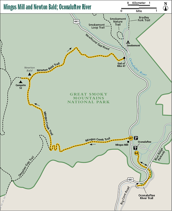
Don’t worry about all the people you see in the trailhead parking lot. They’re here to see Mingus Mill, a restored late nineteenth-century gristmill. You’ll have the hike to yourself. You can explore the mill before you hike or, since it is so close to the parking area, save it for another day when you have more time. The mill still operates using the originally installed water-powered mechanism. Hours may vary, but generally, the mill opens daily in summer and on weekends in spring and fall.
This hike is a good day hike for campers staying at Smokemont Campground. Arrange for a shuttle to the trailhead, make the hike, and walk back to the campground in time for dinner.
Start: Mingus Creek trailhead at Mingus Mill parking area
Distance: 11.4 miles point to point
Hiking time: About 6 hours—day hike or overnighter
Difficulty: Moderate
Trail surface: Gravel road and forest trails
Other trail users: Equestrians permitted on most of the route
Maps: Smokemont USGS quad; Trails Illustrated #229 Great Smoky Mountains; Trails Illustrated #317 Clingmans Dome Cataloochee
Special considerations: You might be tempted to turn this hike into a loop by walking 2.8 miles along Newfound Gap Road, but this is very dangerous. In many places there isn’t much of a shoulder and the heavy traffic is looking out for scenery, not you. It would be a nightmare of a walk.
A park firing range is located near the start of the hike. When the range is in use, the trail could be closed temporarily.
Other: The Mingus Mill parking area fills up on weekends, but if you get there by midmorning, you should be OK. Restrooms are available at the trailhead.
Finding the trailhead: From Oconaluftee Visitor Center, drive 0.4 mile south on Newfound Gap Road and turn left at the sign for Mingus Mill. Reach the parking area immediately (GPS: N35 31.248' / W83 18.553'). The road ends beyond the parking area at a turnaround, and the trail begins as a continuation of the road.
The Hike
From the grounds of Mingus Mill, you can follow the raceway to Mingus Creek and cross over to get on Mingus Creek Trail, but this could be a wet crossing in high water. The parking area for the mill marks the official start of Mingus Creek Trail and this hike. Take the gravel road that begins from the turnaround and follow it along Mingus Creek behind the mill. Cross the creek twice on auto bridges and pass a firing range. (If the range is in use, the trail may be closed temporarily.) Continue on the service road, ascending gradually, and cross the creek once more just before passing an old water plant with an ugly metal building.
The service road ends here and the trail becomes rocky. Soon you cross Madcap Branch on a foot log and come to a fork. A right turn takes you to an old cemetery. Your hike goes to the left and follows Madcap Branch upstream. (Pay attention at the fork, as the most trodden path goes to the right and there may not be a sign.) After rock-hopping the branch and then a feeder, you start to climb. Look for large patches of sharp-lobed hepatica along the trail. The wildflower is unusual in that its distinctive three-lobed leaves remain throughout the winter. The trail continues on a long and sometimes steep ascent, crossing Madcap Branch or its branchlets many times before swinging away and climbing the ridge on switchbacks.
At a small gap in the ridgetop, Deeplow Gap Trail goes straight ahead and down the other side. Your hike goes right and follows up the ridgeline. It starts out surprisingly level and then begins climbing—moderately at first, but with a few steep stretches later on. Occasional views are off both sides of the trail. After following on or near the ridgeline for nearly 3 miles, you arrive at Newton Bald and the junction with Newton Bald Trail. Newton Bald is no longer a bald. Trees completely cover the summit and it’s hard to tell that it was once open.
Turn left (north) onto Newton Bald Trail and hike an easy 0.3 mile to Campsite 52, straddling a small saddle. The trail passes right through the tiny site. Water is available from a very small spring 75 yards down the northeast side. If you’re doing this hike as an overnighter, this is home for tonight.
Backtrack to the junction with Mingus Creek Trail, but stay on Newton Bald Trail. You now have a 5.0-mile near-continuous and sometimes steep descent to Newfound Gap Road. Look out for wildflowers in spring; this trail is a good one for them. About 0.25 mile before reaching the road, you pass a bridle path on the right, and a short distance farther there’s another horse trail on the right. Stay to the left at both junctions.
Miles and Directions
0.0Start on Mingus Creek Trail, which begins at the gravel road leading from the far end of the parking area.
1.3A right fork leads to a cemetery. Go to the left to remain on Mingus Creek Trail.
2.9Junction with Deeplow Gap Trail, which goes straight ahead. Turn right to remain on Mingus Creek Trail.
5.8Junction with Newton Bald Trail on Newton Bald. Turn left (north) and walk along the ridge.
6.1Arrive at Campsite 52. Backtrack to junction with Mingus Creek Trail.
6.4Return to junction with Newton Bald and Mingus Creek Trails. Go to the left on Newton Bald Trail.
11.4End of hike at Newfound Gap Road.