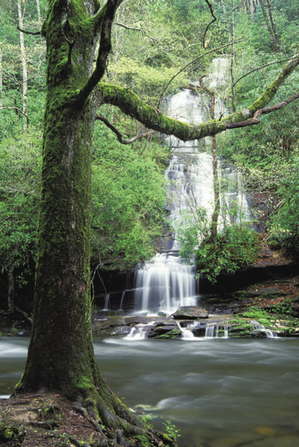
Tom Branch Falls drops directly into Deep Creek.
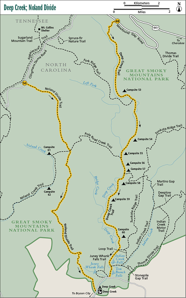
48 Deep Creek
The Deep Creek that most people see is more like a little river, but then most people never venture as far into the headwaters as you will on this hike. Actually, you start on the headwaters and follow the creek downstream, watching it grow by the mile. By the time it reaches the Deep Creek Campground area, it’s a major stream, though not any deeper than other park streams. If you like streams, wildflowers, lush forests, and a hike long enough to make you feel that you’ve accomplished something, this is about as good as it gets in the Smokies.
Start: Deep Creek trailhead on Newfound Gap Road
Distance: 14.2 miles point to point
Hiking time: About 7 hours, with multiple options for camping
Difficulty: Moderate
Trail surface: Forest trail and old forest road
Best season: Spring for the wildflowers
Other trail users: Lower portion of trail is open to equestrians
Maps: Clingmans Dome and Bryson City USGS quads; Trails Illustrated #229 Great Smoky Mountains; Trails Illustrated #317 Clingmans Dome Cataloochee
Special considerations: In wet weather some of the creek crossings could be a little tricky and might require wading. Creek crossings aside, this isn’t the most pleasant trail to hike in the rain. The upper section is heavily overgrown with dog hobble. The wet foliage constantly brushing against you is very irritating.
Other: The parking area at the actual trailhead has room only for a few vehicles. A larger parking area is located 0.1 mile south. There are no facilities, but there are restrooms at Newfound Gap, 1.7 miles to the north.
Finding the trailhead: For the beginning trailhead, from Oconaluftee Visitor Center drive 13.9 miles north on Newfound Gap Road to a small parking area on the left (west) side of the road (GPS: N35 35.960' / W83 25.353'). This is 1.7 miles south of Newfound Gap. Deep Creek Trail begins from the pullout and is obvious. If this parking area is full, there is another parking space located 0.1 mile to the south.
The Hike
Descend from the trailhead on switchbacks through a lush scenic forest and cross several small branches. Wildflowers abound in the wet spots. Lettuce saxifrage grows here—look for its blooms in May and June and its distinctive lance-shaped, coarsely toothed leaves throughout the summer. At about 1.5 miles you enter a boggy and surprisingly flat cove. Passing through the cove, you cross several branches and then meet up with Deep Creek. Swing away from the creek and go on a long stretch where you parallel the creek high on the bank. Dog hobble threatens to take over the trail through here and continues to be a nuisance for several more miles.
Continue downstream, sometimes close by the creek, sometimes high above it. At 3.9 miles you come to the first of eight backcountry campsites on Deep Creek Trail. This one is Campsite 53. The site is not very pleasant—a cleared-out spot in a briar patch with the trail passing right through it. Fork Ridge Trail turns off to the right here, crossing Deep Creek without benefit of a foot log.
Continuing on Deep Creek Trail, you follow along the creek closely but without many good views of it through the dense dog hobble and rhododendron. Come to Cherry Creek and make a tricky rock-hop in normal flows or a wade in high water. Once across Cherry Creek climb up and away from Deep Creek then back down to it. Here the trail and creek are the same for several yards, and in very high water this stretch could be dicey. Look for a fallen hemlock by the creek that has several small trees growing from its trunk. There are birches, rhododendron . . . at least a half-dozen species.
Now leave the creek a bit and pass through a forest with some impressive yellow poplars (tulip trees). The hemlocks here were once impressive but are now skeletons. On returning to the creek, the ground is wet and boggy and you cross over two out-of-character corrugated metal pipes. Beyond the pipes the trail turns left and goes through a rerouted section that avoids even more boggy ground.
Tom Branch Falls drops directly into Deep Creek.
At about 6.5 miles you cross two creeks in quick succession (the first crossing of Nettle Creek might be tricky) and arrive at Campsite 54, just after the crossings. It’s another small site, but it’s much more attractive than Campsite 53. Less than a mile farther, you come to Campsite 55, a horse camp, on the left. Just beyond the campsite, Pole Road Creek Trail turns off to the right and crosses Deep Creep on two foot logs on its way to Upper Sassafras Gap on Noland Divide. Stay straight on Deep Creek Trail.
After a short up-and-down segment, you pass right through Campsite 56, a very small site in a hemlock grove. Soon the trail swings away from the creek and climbs a little to Campsite 57 at the junction with Martins Gap Trail. Campsite 57 is named Bryson Place and is the site of Horace Kephart’s last permanent camp in the Smokies. A few hundred feet off the right side of the trail lies a millstone and plaque honoring Kephart, placed in 1931 by the Horace Kephart Boy Scout Troop. (See the sidebar for Hike 68 for more about Kephart.) This isn’t the best campsite. It’s open and on a slope—and it’s a horse camp. If here in May, look around the horse-hitching area for pink lady’s slipper orchids. Martins Gap Trail goes to the left, between the campsite and hitching area. Again, stay on Deep Creek Trail.
Reach Campsite 58 in another 0.6 mile. It offers no privacy, but its setting right beside Deep Creek makes it appealing. Beyond the campsite the trail does a typical up-and-down routine. On the down side you come to Campsite 59, also beside Deep Creek. It has no privacy either, although a screen of dog hobble offers a little isolation. From here you go on a roller-coaster ride of ups and downs and then make a long, somewhat steep climb, the longest climb of the hike. After the climb an even longer descent takes you to Campsite 60, the prettiest one of all. It sits off the trail enough for a little privacy and has a ground cover of soft pine needles.
Cross Bumgardner Branch on a foot log just past the campsite, make a final climb, then descend to the old road turnaround. From here it’s an easy 2.1-mile walk along the old roadbed to the trailhead.
Miles and Directions
0.0Start on Deep Creek Trail from the parking area.
3.9Campsite 53. Fork Ridge Trail turns to the right here and crosses Deep Creek. Continue following Deep Creel Trail downstream.
6.5Campsite 54.
7.4Campsite 55. A short distance beyond the campsite, Pole Road Creek Trail turns to the right and crosses Deep Creek. Continue following Deep Creel Trail downstream.
7.6Campsite 56.
8.1Campsite 57 and junction with Martins Gap Trail, which goes to the left. Continue following Deep Creek Trail downstream.
8.7Campsite 58.
9.1Campsite 59.
11.6Campsite 60.
12.5Junction with Loop Trail on the left. Continue following Deep Creel Trail downstream.
13.5Junction with Indian Creek Trail on the left. Indian Creek Falls is a short distance up Indian Creek Trail. Continue following Deep Creel Trail downstream.
14.0Pass by Tom Branch Falls, to the left, on the other side of Deep Creek.
14.2End of hike at the lower trailhead.
Options: With eight campsites and five intersecting trails (each offering other hike possibilities), it’s hard to decide how to plan a hike. If doing an overnighter, you might want to stay at Campsite 56, which is about halfway into the hike. On a lazy two-night backpack, a good choice is to camp at Campsite 54 the first night and #60 on the second.