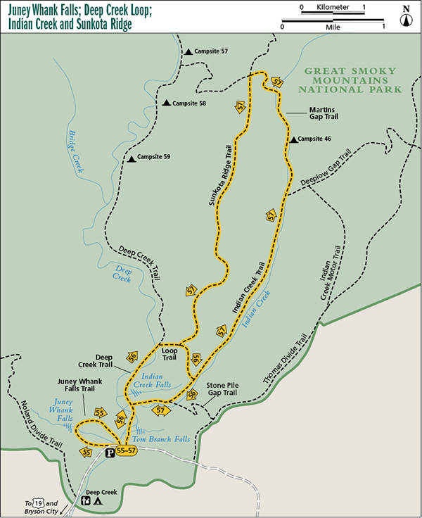
55 Juney Whank Falls
As waterfalls go, Juney Whank Falls isn’t anything to get excited about. However, the trail is short and if you’re in the Deep Creek area for another hike, it’s easy to include this one as well.
Start: Parking area for Deep Creek Trail near Deep Creek Campground
Distance: 0.7-mile loop
Hiking time: About 45 minutes—day hike
Difficulty: Moderate
Trail surface: Packed dirt
Other trail users: Equestrians
Maps: Bryson City USGS quad; Trails Illustrated #229 Great Smoky Mountains; Trails Illustrated #317 Clingmans Dome Cataloochee
Other: If you get here in the middle of a summer weekday, you probably won’t find a parking space in the paved lot. On a weekend you can forget it. Few other places in the park are as crowded. Restrooms are available at the picnic areas.
Finding the trailhead: Downtown Bryson City has many signs that direct you to Deep Creek Campground. As you enter the park, continue on the paved road past the campground entrance and the picnic areas to where the road ends at a turnaround. A paved parking area is on the left. The trail begins from the upper end of the parking area at the sign for Juney Whank Falls. GPS: N35 27.877' / W83 26.051'
The Hike
Don’t worry about the crowds you see at the parking area. They’re all headed up Deep Creek Trail, and except for a short segment at the end, you might have this hike to yourself.
The trail follows Juney Whank Branch upstream a short distance, then swings to the left and away from the creek, climbing to a junction with a bridle path coming in from the left. Stay to the right and continue climbing up the old roadbed. Climb moderately for about 0.2 mile to an obvious path on the right leading to the base of the waterfall.
From the falls, you can backtrack or continue up the bank to rejoin the bridle path (it circles around the top of the falls). Turn right and go 50 feet, then bear to the right off of the horse trail onto an obvious path. This path leads about 0.2 mile through a deep gully to Deep Creek Trail, where a right turn takes you back to the parking area.
Miles and Directions
0.0Start from the upper (north) end of the parking area at the sign for Juney Whank Falls.
0.1Bridle path comes in from the left. Stay to the right, heading uphill.
0.3Turn right on the obvious path and descend about 75 yards to the waterfall. Continue following the path on the other side of the footbridge.
0.4Rejoin the bridle path, which circles around the top of the waterfall. Turn right and go 50 feet to a fork. Turn right at the fork and descend.
0.6Turn right at junction with Deep Creek Trail.
0.7Arrive back at parking area.