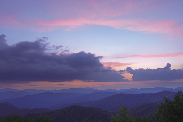
Sunset view from Flat Creek Trail.
72 Flat Creek
Flat Creek Trail is an “unknown gem” in the Smokies. Few people know about it, but those who hike it don’t soon forget it. Although heavily logged before park establishment, the forest walk is now one of the more scenic higher-elevation hikes in the park.
(See map for Hike 71: Balsam Mountain Nature Trail.)
Start: Balsam Mountain Picnic Area
Distance: 6.2-mile loop
Hiking time: About 3 hours—day hike
Difficulty: Moderate
Trail surface: Forest trail
Other trail users: Hikers only
Maps: Bunches Bald USGS quad; Trails Illustrated #229 Great Smoky Mountains; Trails Illustrated #317 Clingmans Dome Cataloochee
Special considerations: To hike this route as described, you have to walk 3.6 miles on Heintooga Ridge Road. Walking on paved roads in the Smokies is normally discouraged, but this road receives relatively little traffic and there’s plenty of space to step off the pavement. It’s a rewarding walk as well, with nice views and abundant roadside wildflowers in summer.
Blue Ridge Parkway, which you must drive to get here, is often closed in winter. However, it normally opens much sooner than the last segment of Heintooga Ridge Road above Polls Gap, which remains closed until mid-May. If you find the road gated, just pull away from the gate and park at a safe place on the side of the road. This is a loop hike, so it doesn’t matter where you start.
Other: Relatively few people come up here, so parking shouldn’t be a problem. Restrooms are available in season at the picnic area.
Finding the trailhead: At Wolf Laurel Gap (Milepost 458.2) on Blue Ridge Parkway, turn north onto Heintooga Ridge Road and drive 8.8 miles to the turnaround at the picnic area. The trail starts to the right of the picnic area at the end of the loop. GPS: N35 34.393' / W83 10.823'
The Hike
Begin at the picnic area at the trail sign on the northwestern end of the parking area. A short walk through a spruce forest takes you to Heintooga Overlook, a little-known view point that provides an open vista toward the west—perfect for sunsets. Becks Bald is prominent in the foreground; Clingmans Dome is far to the left; Mount Guyot is on the extreme right; and Mount LeConte is straight ahead in the distance.
Beyond the overlook the trail forks to the right (the left fork leads back to the picnic area) and soon descends to cross Flat Creek amidst a tangle of rhododendron. The forest is pleasantly open and the ground is carpeted in grass. Although scenic, the grass isn’t natural. Grassy forests are usually a good sign of former logging activity. Grouse don’t care whether it’s been logged or not, and you might flush one out through here.
Sunset view from Flat Creek Trail.
At 1.9 miles you come to a signed side path on the right that leads a few hundred yards to Flat Creek Falls. There’s no good view of the falls from this path and any attempt to find one is dangerous and damaging to the surrounding soil. In spring, right after the road opens and before the leaves come out fully, there’s a fair view of the waterfall from Heintooga Ridge Road.
Back on the main trail, you enter a dense forest and descend to cross a fork of Bunches Creek on a foot log. Turn sharply right, climb a small ridge, and descend to another branch crossing on a foot log. Now make a moderate climb of about 0.25 mile to Heintooga Ridge Road.
Once back on the road, turn left and walk 3.6 miles back to the picnic area. In summer you’ll have plenty of roadside wildflowers to keep you company along the way.
Miles and Directions
0.0Start on Flat Creek Trail on the northwestern end of the traffic turnaround.
0.1Scenic overlook.
1.9Pass by spur to Flat Creek Falls on the right. There is no good view of the waterfall from this path.
2.6Junction with Heintooga Ridge Road (GPS: N35 33.251' / W83 09.832'). Turn left and follow the road back to the parking area.
6.2Arrive back at parking area.
Options: Of course, you can do this trip as a shuttle and eliminate the road portion of the hike. If you have a bicycle, a good option is to leave it at the picnic area (chained, of course), drive back down to the lower trailhead, and hike Flat Creek Trail in reverse. Then you can coast back to your car.