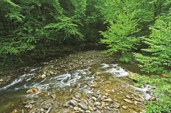
View of Straight Fork at the Beech Gap Trailhead.
73 Hyatt Ridge
Located in the remote Straight Fork section of the park, this “hidden gem” packs a big punch, especially for wildflower lovers. The best part is that you might have the entire hike to yourself. Relatively few people venture into this part of the park, and most of those who do aren’t here for the trails. The scenic Straight Fork runs alongside the access road, providing great opportunities for fishing, sightseeing, and playing.
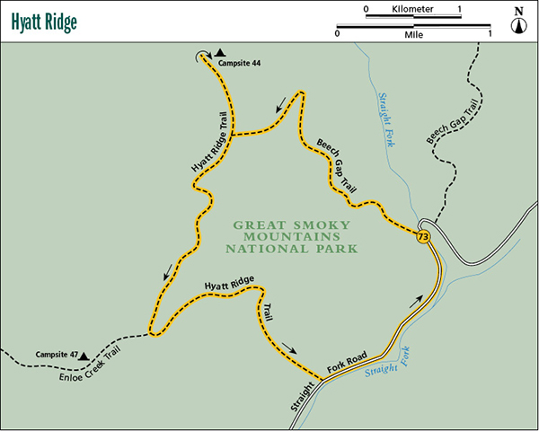
Start: Beech Gap trailhead in the Straight Fork area
Distance: 9.4-mile loop
Hiking time: About 5 hours—day hike or overnighter
Difficulty: Moderate
Trail surface: Forest trails, some very rocky, and gravel road
Best season: Spring for the wildflowers
Other trail users: Equestrians
Maps: Bunches Bald and Luftee Knob USGS quads; Trails Illustrated #229 Great Smoky Mountains; Trails Illustrated #317 Clingmans Dome Cataloochee
Other: You might have to share parking with a few trout fishers, but there should be plenty of room. The closest facilities are back in Cherokee.
Finding the trailhead: Drive 1.2 miles south from Oconaluftee Visitor Center toward Cherokee and turn left at the sign for Big Cove Road, taking the 0.2-mile connector over Oconaluftee River to the road. Turn left onto Big Cove Road and drive approximately 8.6 miles to a fork, just after crossing Raven Fork. Turn right at the fork onto Straight Fork Road and follow it 0.9 mile to a turnaround at a fish hatchery. Leave the pavement and continue on the gravel road. It’s 3.9 miles to a narrow pullout on the right, just before the truss bridge. Beech Gap trailhead is on the opposite side of the road. GPS: N35 37.288' / W83 12.659'
The Hike
Begin on Beech Gap Trail on the west side of the road. Climb steeply through lush spring wildflowers to a point high above Straight Fork, and then swing west and continue a moderate climb in and out of the broad ridges. On the “ins,” you cross several branches. Wildflowers abound in the wet spots throughout the year. In summer you can see jewelweed, coneflower, and joe-pye weed.
After a little more than 2 miles, you swing around a spur extending from Hyatt Bald and then go on a short level stretch before climbing the spur flank to the junction with Hyatt Ridge Trail on the ridgetop. Turn right (north) and ascend the flank of Hyatt Bald to the summit. On the bald is an open stand of beech trees that prohibit good views, but the carpet of grass, ferns, and various wildflowers throughout the season makes the bald a scenic spot. Norway spruce grows here, too. Lumber companies introduced this non-native tree after they logged the native red spruce.
View of Straight Fork at the Beech Gap Trailhead.
Follow the narrow ridge from the bald and reach an open, heavily overgrown stretch. Soon reenter the forest and come to Campsite 44, one of the most delightful sites in the park. The campsite sits in a glade by the head of McGee Spring at an elevation of more than 5,000 feet. Huge red spruce and yellow birch dominate the old-growth forest. McGee Spring, said to be one of the coldest springs in the Smokies, gurgles out of the bank about 200 feet in front of the camp. Lush foliage covers the ground from spring through fall. False hellebore, coneflower, bee balm, and many other wildflowers grow here.
Backtrack from the campsite to the junction with Beech Gap Trail and then continue on Hyatt Ridge Trail. Descend steeply to a saddle and then climb gradually a short distance before descending again to begin a narrow ridge walk through mountain laurel, flame azalea, blueberries, and at one point, lichen-covered trees. The droopy lichens create an eerie sight in the fog.
A steep descent takes you to a gap and the junction with Enloe Creek Trail, which comes up the right side of the ridge. You want to turn left (northeast) and continue on Hyatt Ridge Trail. The trail leaves the ridge and makes a steady and steep descent to Straight Fork Road. This segment is an ankle-turner. It’s muddy and covered in loose rocks that twist under your feet. It also has wonderful wildflower displays—foliage literally carpets the slopes.
Once you reach the road, turn left and follow it 1.3 miles back to your vehicle.
Miles and Directions
0.0Start on the west side of the road at the trail sign for Beech Gap Trail.
2.8At the ridgetop turn right (north) onto Hyatt Ridge Trail.
3.7Reach the end of the trail at Campsite 44 beside McGee Spring. Backtrack to the junction with Beech Gap Trail.
4.6Arrive back at junction with Beech Gap Trail. Continue straight along the ridge on Hyatt Ridge Trail.
6.3Junction with Enloe Creek Trail, coming up from the right. Turn left and descend the ridge, remaining on Hyatt Ridge Trail.
8.1Arrive at the gravel road. Turn left and follow the road back to your car.
9.4Arrive back at trailhead.
Option: While this hike is easy to do as a day hike, Campsite 44 is perfectly situated for making the hike an overnighter. There’s a good chance you’ll have the site, and the trail, to yourself for the entire trip.