
Dan Cook Place in Little Cataloochee.
76 Little Cataloochee
Few hikes in the Smokies offer a cultural experience as rewarding as this one. In Little Cataloochee you’ll find restored cabins, cemeteries, rock walls and foundations, old metal and ceramic artifacts scattered about, and the highlight of the hike for many, Little Cataloochee Church perched on a knoll. It’s impossible to walk through the cove without wondering about life before the park was established. Unlike neighboring “Big” Cataloochee Valley, and Cades Cove over on the Tennessee side of the park, the only way to see Little Cataloochee is on foot or horseback, which makes the experience even richer.
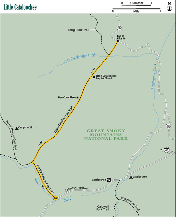
Start: Pretty Hollow Gap trailhead in Cataloochee Cove
Distance: 6.0 miles point to point
Hiking time: About 3.5 hours—day hike
Difficulty: Moderate
Trail surface: Rocky forest trail and dirt road
Other trail users: Equestrians
Maps: Cove Creek Gap USGS quad; Trails Illustrated #229 Great Smoky Mountains; Trails Illustrated #317 Clingmans Dome Cataloochee
Special considerations: Cataloochee Valley is gated at night, so you’ll want to make sure to complete your hike and shuttle before it gets dark.
Other: The starting trailhead has room for several vehicles, but it fills quickly on summer weekends, particularly when horse trailers are here. The ending trailhead has room on the side of the road for only a couple of vehicles. Pit toilets are located near the start.
Finding the trailhead: This hike starts in remote Cataloochee Valley, in the extreme southeastern section of the park. From exit 20 on I-40, go 0.1 mile south on US 276 and turn right onto Cove Creek Road. Follow this road 5.7 miles to the park boundary (it changes to gravel along the way), and continue 1.7 miles to a four-way intersection, with a paved road on the left and a gravel road to the right and straight ahead. Turn left onto the paved road and drive 2.8 miles to the beginning of Cataloochee Valley, and then continue another 1.8 miles to a parking area on the right, just before the road crosses Palmer Creek. (It’s 4.6 miles total along the paved road.) Pretty Hollow Gap Trail begins here as a dirt road. GPS: N35 37.600' / W83 06.742'
The Hike
Begin on an easy grade along scenic Palmer Creek. At 0.2 mile you pass to the left of a large horse camp, and at 0.8 mile Little Cataloochee Trail turns to the right (northeast). Take Little Cataloochee Trail and climb moderately, soon picking up Davidson Branch and walking in the creek bed for a short distance. The trail becomes very muddy in places and continues to be rocky. You’ll cross the creek several times as you climb. After the final crossing the trail swings away to the right, leaving the Davidson Branch drainage but quickly picking up the drainage of a side stream.
Continue climbing along this side stream and soon pass an old homesite on the left. Look for a well-constructed rock wall and the rotten remains of a log building. The logs are American chestnut—most other woods would have decayed long ago. You’ll also see yucca plants and, in spring, daffodils—both are good indicators of an old homeplace. Farther ahead, in Little Cataloochee Valley, you’ll see lots more of these plants. Beyond the old homeplace the trail dips to cross the branch and then begins the steepest part of the hike. Look for another rock wall on the left as you climb alongside the creek.
You soon reach Davidson Gap after making a sharp switchback to the right. Descend from the gap rather steeply, passing a couple of rock walls on the right. You are entering Little Cataloochee Valley now, and for the next couple of miles, you’ll see abundant evidence of the heavy settlement that occurred here. Old homesites are now overgrown with trees, but you can still distinguish many of them. Scattered all about the valley are remnants of rock walls, pieces of metal, shards of glass and ceramics, and homesite indicator plants such as periwinkle and the aforementioned yucca and daffodils.
Dan Cook Place in Little Cataloochee.
The steep trail soon moderates and joins an old roadbed for an easy walk. Come to Dan Cook Place on the left at 3.3 miles. This fine cabin is a reconstructed version of an original cabin that was destroyed by vandals in the 1970s. It is among the most picturesque cabins in the park. Across from the cabin is the rock foundation of an apple house.
Continue the gentle descent and then make an easy climb to reach Little Cataloochee Baptist Church, beautifully situated on a grassy knoll overlooking a cemetery. Built in the late 1800s, the church still stands in its original condition and is still the site of occasional services. From the church, the road descends rather steeply and passes a spring on the left side of the road, then goes through the old community of Ola. Ola once boasted several structures, including the finest house in Little Cataloochee, which stood off the right side of the road just before the bridge over Little Cataloochee Creek. In winter you can find scattered artifacts of the community, but the area is now nearly overgrown.
Cross Little Cataloochee Creek and begin ascending. You soon come to a sharp right swing in the road, where a side path on the left leads in a few hundred feet to John Jackson Hannah Cabin. The cabin is open for exploration. Shortly beyond the cabin is the junction with Long Bunk Trail on the left (northeast). About 0.2 mile up this trail is Hannah Cemetery—a nice side trip. Little Cataloochee Trail continues from Long Bunk trailhead another 1.1 miles on a moderate course to NC 284 and the end of the hike. At 0.3 mile before the end, the old road crosses Correll Branch in what used to be a scenic forest with many large eastern hemlock trees. The trees now stand as skeletons, having succumbed to the hemlock woolly adelgid. (See the sidebar for Hike 36.)
When you reach NC 284, you have two choices if you didn’t leave a shuttle vehicle. You can return the way you came or walk back to Cataloochee Valley along the road. Most of the park’s paved roads are not suitable for pedestrians, but out here in the middle of nowhere, the hike wouldn’t be a lot different from walking on a trail. Just be careful as you walk around the blind curves.
Miles and Directions
0.0Start on Pretty Hollow Gap Trail, following Palmer Creek upstream.
0.8Turn right (northeast) onto Little Cataloochee Trail.
2.6Reach Davidson Gap and begin descent into Little Cataloochee Valley.
4.9Long Bunk Trail goes to the left (northeast) and leads 0.2 mile to Hannah Cemetery, a recommended side trip. Little Cataloochee Trail continues straight ahead.
6.0Little Cataloochee Trail ends at NC 284. Return the way you came or hike the road back if you didn’t leave a shuttle vehicle.
Options: From Cataloochee Valley, most people hike the trail as described here—a shuttle hike—leaving a vehicle at the other end. Those who are interested only in seeing the historic structures in Little Cataloochee usually hike in from NC 284 and then backtrack. A great option is to leave a bicycle on NC 284 and ride back to the trailhead in Cataloochee.
At the start of the hike, you can cross over Palmer Creek on the bridge and take the path on the right to the old Beech Grove School for a quick side trip. Actually, if you’re interested in old schools, churches, and cabins, you should plan to spend a day exploring all of Cataloochee in addition to the hike through Little Cataloochee.