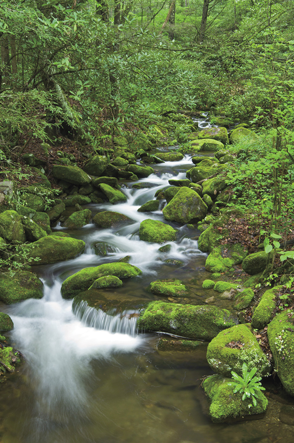
Chestnut Branch cascades through a lush forest.
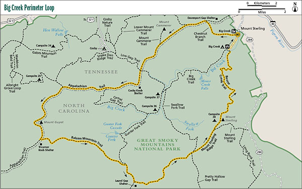
80 Big Creek Perimeter Loop
Hike 79 is among the best two-night backpacks in the park. The hike outlined here, which follows a portion of that hike’s route, is among the finest three-night backpacks in the park. It follows high mountain crests as it loops around the entire upper Big Creek drainage. The high-elevation forests are dark and mysterious, even with the disheartening death of trees from introduced pests and air pollution. If you’re looking for a challenging, grand adventure in the Smokies, this is it.
Start: Chestnut Branch trailhead at Big Creek Ranger Station
Distance: 34.0-mile loop
Hiking time: About 19 hours—3-night backpack, 4-nighter, or killer 2-nighter
Difficulty: Strenuous, due to steep grades and rocky trails
Trail surface: Forest trails and old logging grades, some very rocky
Other trail users: First section on Chestnut Branch Trail and last section on Baxter Creek Trail are for hikers only; the rest is open for equestrians
Maps: Waterville, Hartford, Luftee Knob, Mount Guyot, and Cove Creek Gap USGS quads; Trails Illustrated #229 Great Smoky Mountains; Trails Illustrated #317 Clingmans Dome Cataloochee
Special considerations: The shelters and campsite on this hike are popular. Make your reservation as early as possible and be prepared with alternative dates when you call. Although the first night’s stay on this hike is only 8.4 miles from the trailhead, it’s a tough climb. Experienced hikers can make it in 4 or 5 hours without pushing themselves, but inexperienced hikers need to head out early in the morning and plan on an all-day hike. Actually, inexperienced hikers probably shouldn’t be attempting this trip at all.
Winter is a great time to make this hike. The views are open and you’ll meet far fewer hikers on the trail. However, if you do choose a winter hike, you need to make a frank assessment of your backpacking abilities and prepare for snow and frigid conditions. It is not uncommon to leave from the trailhead with clear skies and temperatures in the fifties, only to find yourself plowing through snow and subfreezing temperatures in the higher elevations. Tricorner Knob Shelter, the most remote shelter in the park, has hosted many a hiker stranded in deep snow.
Other: Parking space is never a problem here. Pit toilets are located here, and the picnic area that is 0.6 mile farther along the road has a restroom building, although it closes in winter. Portable toilets are available in winter.
Finding the trailhead: Take the Waterville exit (exit 457) off I-40 and cross Pigeon River. Stay to the left after the crossing and follow the road 2.0 miles to an intersection, passing the Walters Power Plant on the way. The intersection marks the community of Mount Sterling. Go straight, and enter the Big Creek section of the park. Follow the road 0.2 mile to the ranger station and parking area on the right. Chestnut Branch Trail begins about 200 feet farther up the road, on the right. GPS: N35 45.610' / W83 06.386'
The Hike
Begin ascending Chestnut Branch Trail alongside Chestnut Branch on an old logging grade. Pass a huge oak tree on the left that somehow escaped the logger’s ax. Several families once lived along Chestnut Branch; perhaps this tree was part of their holdings. You can see signs of settlement along the lower portion of the hike. Except for one easy stretch, it’s a steady climb all the way to the Appalachian Trail (AT).
Reach the AT at a small gap. To the right, it’s only 1.9 miles to Davenport Gap and the eastern trailhead for the Smokies portion of the AT. If you had started there, you would have added more than the 0.6 mile of road walking that’s included in the route outlined here and you wouldn’t have had a good place to leave your vehicle. The hike as described is much more “loop friendly.”
Turn left (southwest) onto the AT and make a continuous ascent to Lower Mount Cammerer Trail, on the right. Continue climbing on the AT and pass through a boulder field on switchbacks. Ferns and mosses cover the rocks and varieties of wildflowers grow among them. At an outside switchback around a ridge, you have the first open view, this one toward the northeast. Now the trail becomes even more interesting as it climbs the steep slope of Cammerer Ridge through rhododendron and by rock walls. You soon come to another outside turn at a rock outcrop. From this outcrop are commanding views into Pigeon River Valley and the Big Creek watershed. As good as this view is, it’s just a tease for what’s ahead.
Continue climbing and reach a tiny gap where Mount Cammerer Trail cuts sharply back to the right (north). If you think you can add 1.2 miles to your hike and still make it to Cosby Knob Shelter before dark, you definitely should take this side trip. The trail leads 0.6 mile along the ridge to Mount Cammerer Lookout (see Hike 45).
The view from the lookout is outstanding in all directions, but study carefully the view from the southwest to the southeast. That ridgeline you see is the one you will follow later in the hike. Look southeast across the Big Creek watershed to the tower rising above the trees. That’s Mount Sterling Fire Tower and at its base is Campsite 38, your third night’s camp on a three-night backpack. Yep, you’ve got a long haul ahead of you!
Back on the AT, continue heading south on a mostly downhill stretch to Low Gap and the junction with Low Gap Trail. Low Gap Trail crosses here, having climbed from Cosby Campground to the right and Walnut Bottoms to the left. Continue straight on the AT and climb steadily for 0.8 mile to a side path on the left, leading in a few hundred feet to Cosby Knob Shelter. The shelter is a good choice for your first night’s camp.
Pressing on from the shelter, climb through a particularly scenic forest of spruce, hemlock, and rhododendron as you skirt the summit of Cosby Knob. Soon you begin a long descent to Camel Gap and the junction with Camel Gap Trail, forking off to the left. Continue to the right on the AT and begin a long, steady ascent of 2.3 miles to another fork. Snake Den Ridge Trail goes to the right here, while your trail goes left and—you guessed it—continues climbing.
As you climb from the junction with Snake Den Ridge Trail, you might spot pieces of wreckage from an Air Force jet that crashed into Inadu Knob on the evening of January 4, 1984. According to the book Mayday! Mayday! by Jeff Wadley and Dwight McCarter, the jet was flying at 450 mph when it hit the mountain just 80 feet shy of the summit. The impact created the largest crash site in the Smokies, at nearly 20 acres. You might see pieces of the wreckage along this stretch. At one time there was a heavy chunk of an airplane leaning against the Cosby Knob Shelter, but if it was from this crash site, you have to have sympathy for the person who lugged it that far. (You probably should question their sanity as well.)
Chestnut Branch cascades through a lush forest.
Finally, you top out on a grassy ridge with a great view ahead of Mount Guyot and Old Black. Continue through an open area and pass over a helicopter landing pad before entering the forest again. The AT skirts the summit of Old Black (6,370 feet) and then crosses a couple of good springs as it skirts the summit of Mount Guyot. At 6,621 feet, Guyot is the second-highest mountain in the park. As you skirt some 300 feet below the summit, you pass through a tangle of dead and fallen Fraser fir.
After you reach Balsam Mountain Trail on the left, continue on the AT a short distance to the side path on the left that leads to Tricorner Knob Shelter, one of the most remote shelters in the park. This is probably where you’ll sleep tonight if doing this hike as a three-nighter. The next morning, walk back up to Balsam Mountain Trail and turn right onto it.
After the hike you just made on the AT, you’re going to enjoy the next 9.7 miles. Except for a few short spurts, it’s nearly level the entire distance. The first 5.8 miles take you on a heavily overgrown course to Mount Sterling Ridge Trail, on the left. (You pass Gunter Fork Trail at 4.9 miles; go right/southeast to stay on Balsam Mountain Trail.) At the Mount Sterling Ridge Trail junction, Balsam Mountain Trail continues 0.2 mile to Laurel Gap Shelter. If you planned this trip as a four-nighter, the shelter is your third night’s stay. Most hikers will want to hike straight through from Tricorner Knob to Mount Sterling in a day, a distance of 11.5 miles.
Now on Mount Sterling Ridge Trail, the level hiking continues. For some 3 miles, you hardly leave the contour line as you pass through a rather uneventful forest. You cross a number of headwater branches in this segment, a few of them surprisingly large for this elevation. Leaving the contour line, you enter a scenic open birch forest and begin an undulating course before descending to Pretty Hollow Gap. The gap marks the junction with Swallow Fork Trail and Pretty Hollow Gap Trail, coming up from the left and right, respectively. Swallow Fork Trail is the route you take in Hike 79 to get to this point.
From the gap, continue straight (east) on Mount Sterling Ridge Trail. The first 0.5 mile from the gap ascends steeply to cross a knoll in a particularly beautiful forest of spruce, birch, and beech. You soon begin ascending again and merge onto Mount Sterling Trail, coming in from the right. From here, it’s 0.4 mile to the summit of Mount Sterling and Campsite 38. This is your final night’s camp. The steel fire tower at the summit is open for climbing and is a highlight of the hike. When the wind howls, it’s a little frightening climbing to the top, but you need to get above the trees at least. The panoramic view is among the finest in the park.
Baxter Creek Trail, which you will use to get down the mountain, starts on the summit of Mount Sterling by the base of the tower. The trail descends steadily (sometimes steeply) to Big Creek Picnic Area in 6.1 miles, with superb forest scenery along most of the trail. About 0.25 mile down from the fire tower, you come to a signed side path on the left that leads in a couple hundred yards to a reliable spring. On the main trail, hike along a ridge and through switchbacks in a boulder field. Lush, thick moss covers every ground surface you see. This stretch is reminiscent of a southeast Alaska rain forest.
About 2 miles from Mount Sterling, you make an extreme left switchback off the ridgeline and enter an enchanted old-growth forest with several species of trees. Look all around through here but especially above the trail toward the ridge, where some gigantic gnarly maples grow. Farther down, you cross a tributary and soon begin paralleling Baxter Creek. Several large yellow poplars (tulip trees) grow in this scenic, open forest. There are some big hemlocks here too, but they are all dead from the adelgid attack (see the sidebar for Hike 36).
After crossing Baxter Creek you pass through a dense stand of second-growth yellow poplar. At the lower end of the poplar grove, the trail makes a sharp right turn and goes a few yards to cross a small stream. At the right turn, a side path turns to the left and leads a few hundred yards to one of the tallest standing chimneys in the park. Along the way it passes a stone structure of some sort that has some old metal artifacts piled on top. You can easily see it from the main trail when the leaves are off the trees.
After crossing the small stream, Baxter Creek Trail soon reaches the long footbridge over Big Creek. The picnic area is on the far side. Walk through the picnic area and then follow the gravel road back to your car.
Miles and Directions
0.0Start on Chestnut Branch Trail at the parking area beside Big Creek Ranger Station.
2.1Junction with the AT. Turn left (southwest) on the AT.
3.0Junction with Lower Mount Cammerer Trail on the right. Continue following the AT.
5.3Junction with Mount Cammerer Trail, cutting sharply to the right. The trail leads 0.6 mile to the lookout on Mount Cammerer (Hike 45). If not taking this side trip, continue straight ahead on the AT.
7.4Low Gap Trail crosses the AT at Low Gap. Continue straight ahead on the AT.
8.2Side path on the left leads to Cosby Knob Shelter.
9.8Camel Gap Trail forks to the left. Stay to the right on the AT.
12.1Snake Den Ridge Trail forks to the right. Stay to the left on the AT.
15.8Turn left on Balsam Mountain Trail. A few hundred feet farther on the AT is a side path on the left leading to Tricorner Knob Shelter. If overnighting at the shelter, return to Balsam Mountain Trail in the morning.
20.7Junction with Gunter Fork Trail. Stay to the right (southeast) on Balsam Mountain Trail.
21.6Junction with Mount Sterling Ridge Trail, on the left. Laurel Gap Shelter is 0.2 mile to the right on Balsam Mountain Trail. To continue the hike, turn left onto Mount Sterling Ridge Trail.
25.5Junction with Pretty Hollow Gap and Swallow Fork Trails on the right and left. Continue straight on Mount Sterling Ridge Trail.
26.9Junction with Mount Sterling Trail, coming up from the right and continuing straight ahead. Continue straight along the ridge.
27.3Arrive at summit of Mount Sterling and Campsite 38. Take Baxter Creek Trail, which begins near the base of the fire tower.
33.4Arrive at Big Creek Picnic Area. Walk through the picnic area and onto the gravel entrance road. Follow the road back to your car.
34.0Arrive back at the start of the hike.
Options: For most people, the best option for camping is a three-night backpack, staying the first night at Cosby Knob Shelter, the second night at Tricorner Knob Shelter, and the third night at Campsite 38 on Mount Sterling. For a tough two-nighter, you could stay the first night at Cosby Knob Shelter and the second night at Laurel Gap Shelter. If you’re like a Navy SEAL in training, you could head out early in the morning and spend one night at Tricorner Knob Shelter. For a “stop and smell the roses” trip, you could do a four-nighter, staying at all three shelters and Campsite 38.
Combining all the trails in the Big Creek and Cosby section of the park offers unlimited backpacking possibilities, especially with the use of shuttles. Study a trail map for possibilities.