82 Appalachian Trail East
Sections of this hike are covered in other hikes in this guidebook and there is no shortage of literature about the Appalachian Trail (AT). The intent here is simply to provide a concise outline of key points and alert you to any potential concerns along the way.
A good time to make this trip is in October or November, when the crowds have thinned. In October there will be crowds from Newfound Gap to Charlies Bunion, but most of the “leaf peepers” don’t get far from their cars. In autumn you also avoid the heat of summer, which is good on a hike that has no streams to dip into. However, you have to prepare for cold weather. Snow is common in November, and you should come prepared for it in October.
Obviously, for this hike you want to remain on the AT at all trail junctions, so this isn’t necessarily specified in the directions.
Start: Newfound Gap
Distance: 31.5 miles point to point
Hiking time: About 17 hours—2-night backpack, 3-nighter, or tough overnighter
Difficulty: Strenuous, due to steep grades and very rocky trail
Trail surface: Forest trails and hard-packed dirt paths, some very rocky and rooty
Other trail users: Equestrians permitted on about two-thirds of the route
Maps: Clingmans Dome, Mount LeConte, Mount Guyot, Luftee Knob, Hartford, and Waterville USGS quads; Trails Illustrated #229 Great Smoky Mountains; Trails Illustrated #317 Clingmans Dome Cataloochee
Special considerations: Read the introduction to the AT at the beginning of this section for general considerations. The implications of making extended winter hikes at these elevations can’t be overstated. If you are not experienced in winter backpacking, this is not the place to learn.
This hike outlines the entire eastern stretch of the AT from Newfound Gap to Davenport Gap, but you may want to consider ending at Big Creek Ranger Station instead of Davenport Gap. If you’re leaving a shuttle vehicle, it will be much safer at the ranger station than at the gap. Dropping off the AT 1.9 miles short of the gap and hiking 2.1 miles down Chestnut Branch Trail adds only 0.2 mile to the total distance. If you’re determined to hike all of this section of the AT, you could still leave your car at the ranger station and walk an extra 1.3 miles along the road.
Other: Newfound Gap has a very large parking lot, but it can fill up on weekends or any day during the summer and autumn season. Restrooms are located here.
There is very limited parking and no facilities at Davenport Gap at the end of the hike. Ample parking is available at Big Creek Ranger Station. Pit toilets are available here.
Finding the trailhead: The trailhead is located at Newfound Gap Overlook on the Smokies crest. Drive 15.5 miles north on Newfound Gap Road from Oconaluftee Visitor Center or 12.7 miles south from Sugarlands Visitor Center. The trailhead is on the northeast end of the parking lot, between the paved path leading to the restrooms and the Rockefeller Memorial. GPS: N35 36.669' / W83.25.495'
You need to leave a second vehicle or arrange for a shuttle to pick you up at Davenport Gap or Big Creek Ranger Station. Take the Waterville exit (exit 457) off I-40 and cross Pigeon River. Stay to the left after the crossing and follow the road 2.0 miles to an intersection, passing the Walters Power Plant on the way. The intersection marks the community of Mount Sterling. For the ranger station, go straight and enter the Big Creek section of the park. Follow the road 0.2 mile to the ranger station and parking area on the right (GPS: N35 45.610' / W83 06.386'). For Davenport Gap, turn right at the intersection and drive 1.1 miles. There is no parking lot here, just a narrow pull-out a short distance from the gap. GPS: N35 46.243' / W83 06.669'
The Hike
Begin hiking from the northeast corner of the parking area. The trail starts out level and wide, but you soon begin a 1.5-mile steady ascent to a grassy knoll. You’re walking through a high-elevation spruce-fir forest, with occasional openings providing vistas of Mount LeConte to the north. In late April and early May, spring beauty and trout lily cover the ground.
From the knoll, descend 0.2 mile to a gap and the junction with Sweat Heifer Creek Trail at a huge, gnarled birch tree. Continue east on the AT and begin a steep ascent. You soon pass an open view into North Carolina, taking in Clingmans Dome, Newfound Gap Road, and a glimpse of Bryson City. At 2.7 miles you reach the junction with The Boulevard Trail. The Boulevard Trail forks left (north) and leads to Mount LeConte. For a terrific side trip, follow The Boulevard Trail about 0.1 mile to a side path on the right for the Jumpoff. There may be a sign here. It is at a wide spot in the trail created by an uprooted tree on the left. The path goes to the right and climbs the bank on rocks and roots. The rugged path leads about 0.5 mile to an overlook that provides a great view of Charlies Bunion.
 While you’re huffing and puffing along the Appalachian Trail, think about this. On May 19, 2011, Smokies park ranger David Worth completed 71.4 miles of the trail through the park in 14 hours, 50 minutes. That’s averaging roughly 1 mile every 12 minutes over some of the most rugged terrain in the East.
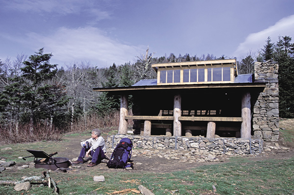
Now back on AT at the junction with The Boulevard Trail, continue heading northeast on the AT. After 0.3 mile a short side path on the right leads to Icewater Spring Shelter, situated in an open grassy area with good views. You’ll probably see day hikers here, posing for pictures in front of the shelter.
Just beyond the shelter the trail passes literally over Icewater Spring. A rusty old pipe provides a drop so that you can fill a water bottle, but there’s something unappealing about drinking water that comes out of a heavily trodden trail. (Be sure to treat all drinking water in the Smokies, no matter the source.)
Beyond the spring it’s an easy hike of about a mile to the side trail for Charlies Bunion, on the left. Do yourself a favor and take this side path. The bare, jagged cliffs of Charlies Bunion remind you more of the young Rockies than the old, worn Appalachians. The views are spectacular. To the west is the Jumpoff; to the northwest is the unmistakable Mount LeConte; and to the northeast is Greenbrier Pinnacle. You’ll want to spend some time here, but take extra precaution. Many people have fallen while climbing on the rocks.
Back on the AT it’s 0.4 mile to the junction with Dry Sluice Gap Trail. Beyond the junction you pass over the Sawteeth, a fitting name for this series of narrow jagged ridges. The views through here are good, but nothing like what you experienced at Charlies Bunion. The hiking is typical AT ridge walking, with ups, downs, and short levels. About 4 miles from Charlies Bunion, and after an arduous ascent, the AT makes a sharp bend to the right (south) and descends along the east side of Laurel Top. Mountain laurel grows densely here, attesting to the mountain’s name. Good views of Mounts Chapman, Guyot, and Sequoyah are to the east.
Reach Bradley’s View, one of the best of the hike, at 8.9 miles. At 10.5 miles Hughes Ridge Trail cuts sharply right. A 0.4-mile hike down this trail brings you to Pecks Corner Shelter.
Beyond the junction with Hughes Ridge Trail, you hike along perhaps the least-traveled and most remote stretch of the AT in the park. That doesn’t mean you won’t see other hikers, but you’ll probably see fewer here than elsewhere on the trail. Less than a mile from Hughes Ridge Trail, you come to a rock outcrop called Eagle Rocks. The view from here into the Middle Prong watershed is spectacular. Descend from Eagle Rocks to a gap and climb again to cross over Mount Sequoyah, just below the summit. Now make a long, gradual descent before climbing again to swing around Mount Chapman. Top out a good distance below the summit of Mount Chapman and descend to a gap. A short climb from the gap takes you to Tricorner Knob Shelter, on the right.
An Appalachian Trail hiker takes a break at Icewater Spring Shelter.
Balsam Mountain Trail turns to the right a short distance beyond Tricorner Knob Shelter. As you swing around Mount Guyot, some 300 feet below the summit, you pass through a tangle of dead and fallen Fraser firs. You’ll cross a couple of good springs along this section—the water from them eventually flows over Ramsey Cascades. At 6,621 feet, Guyot is the second-highest mountain in the park. After skirting Guyot you swing around the summit of Old Black and then enter an open grassy area with a helicopter landing pad. As you top out on a grassy ridge, look behind you for a great view of Old Black and Mount Guyot.
As you descend to the Junction with Snake Den Ridge Trail, you might spot pieces of wreckage from an Air Force jet that crashed into Inadu Knob on the evening of January 4, 1984. According to the book Mayday! Mayday! by Jeff Wadley and Dwight McCarter, the jet was flying at 450 mph when it hit the mountain just 80 feet shy of the summit. The impact created the largest crash site in the Smokies, at nearly 20 acres. You might see pieces of the wreckage along this stretch. At one time there was a heavy chunk of an airplane leaning against the Cosby Knob Shelter, some 4 miles away, but if it was from this crash site, you have to have sympathy for the person who lugged it that far.
Beyond the junction with Snake Den Ridge Trail, you continue on a long steady descent of 2.3 miles to the junction with Camel Gap Trail at Camel Gap. Now you start climbing again and skirt the summit of Ross Knob and then Cosby Knob, before descending to a side path on the right leading to Cosby Knob Shelter. Continue descending for 0.8 mile to Low Gap and the junction with Low Gap Trail.
From Low Gap, begin a steady climb for about a mile before leveling out on an easier grade. At 2.1 miles from Low Gap, you reach the junction with Mount Cammerer Trail, forking to the left. No matter how exhausted you may be, do yourself a favor and follow the path for 0.6 mile to the lookout on Mount Cammerer. It’s a highlight of the AT hike.
Continuing on the AT, make a long steady descent, passing a couple of good views at rock outcrops. Reach the junction with Lower Mount Cammerer Trail in 2.3 miles from the side path to Mount Cammerer. From the junction, continue descending another 0.9 mile to the junction with Chestnut Branch Trail.
If you left your vehicle at Big Creek Ranger Station, from the junction with Chestnut Branch Trail, you can turn right onto the trail and hike 2.1 miles to the ranger station. If you left your vehicle at Davenport Gap or if you want to complete the AT, continue on a short, level stretch and then descend steeply to a side path on the left leading to Davenport Gap Shelter. From the shelter, continue descending nearly a mile to Davenport Gap. If you left your vehicle at the ranger station, turn right onto NC 284 and walk 1.1 miles to the intersection in the community of Mount Sterling. Turn right to reenter the park, and walk 0.2 mile to the ranger station.

Miles and Directions
0.0Start on the northeast end of the parking lot.
1.7Sweat Heifer Creek Trail comes in from the right.
2.7The Boulevard Trail forks to the left (north). See hike text for a side trip from here.
3.0Short path on the right leads to Icewater Spring Shelter.
4.0Side path on the left to Charlies Bunion.
4.4Junction with Dry Sluice Gap Trail, on the right.
10.5Junction with Hughes Ridge Trail on the right. Pecks Corner Shelter is 0.4 on Hughes Ridge Trail.
15.8Tricorner Knob Shelter and junction with Balsam Mountain Trail, on the right.
19.6Junction with Snake Den Ridge Trail on the left.
21.9Junction with Camel Gap Trail on the right.
23.5Side path on the right to Cosby Knob Shelter.
24.3Junction with Low Gap Trail on both sides.
26.4Junction with Mount Cammerer Trail on the left.
28.7Junction with Lower Mount Cammerer Trail on the left.
29.6Junction with Chestnut Branch Trail on the right.
30.6Side path on the left to Davenport Gap Shelter.
31.5Davenport Gap.
Options: If you’re doing this hike as a two-nighter, a good plan is to leave early in the morning from Newfound Gap and hike to Pecks Corner Shelter for the first night’s stay. The next day you’d hike to Cosby Knob Shelter and stay there. This is certainly doable for experienced hikers, but if you haven’t been on a trail in a while, you probably should do the trip as three-nighter, staying at Icewater Spring, Pecks Corner, and Cosby Knob Shelters. On a four-nighter, you’d add Tricorner Knob Shelter.