Prairie grasses ride this climatic roller coaster with composure. Species that couldn’t stay the course fell into extinction in ages long past, leaving behind the modern community of hardy survivors. Each of these successful species has been further refined over the past several thousand years, producing subspecies, or varieties, that are finely attuned to local conditions. A native grass from Alberta, for example, typically achieves maturity in a matter of weeks, fitting its life cycle to the abbreviated growing season of the northern plains. But a clump of the same species from Missouri or Oklahoma is programmed to take its time, pacing its activities to the more leisurely schedule of southern climes. These kinds of local, genetic differences have been detected in a wide range of native grasses, including blue grama, its cousin sideoats grama, the compact-and-graceful June grass, switchgrass, and both big and little bluestem. Natural selection, that master gardener, has been at work on them.
The one climatic factor that presents a continuing challenge for prairie grasses is the moisture supply. Over the Great Plains as a whole, precipitation is more variable than it is almost anywhere else on the continent, with years that are both much wetter and much drier than the long-term norm. (One study of precipitation records in western Kansas, for example, showed that in most months the amount of moisture received was either significantly below or significantly above average. Only “normal” values were truly abnormal.) When the rains are generous, the prairie flourishes and blooms; but when drought sets in, the grasses—indeed the whole ecosystem—are severely tested. More than any other single factor, the limits to growth on the prairies are set by precipitation.
> ANCESTRAL ECHOES
Several million years ago, perhaps about the time when miniature rhinos and dog-sized horses were roaming across the prehistoric savannas of the Great Plains, life was confronted by a major challenge. For some unknown reason, the concentration of carbon dioxide in the atmosphere had begun to drop—so much so that certain plants were left gasping for breath. Without adequate carbon dioxide, they could not easily carry out the life-giving process of photosynthesis.
Some of the afflicted plants, including several families of grasses, responded to this crisis with a major innovation, the invention of a completely new method of photosynthesis. Unlike the old, so-called C3 pathway, which had chugged along for millennia by linking carbon atoms in three-atom molecules, the new, improved C4 model produced more carbohydrates from the same amount of carbon dioxide by linking carbon in four-carbon molecules. But to achieve this enhancement, the plants relied on an enzyme that required relatively high temperatures, with an ideal range between 75˚F and 85˚F (25˚c and 30˚c ), up from the old standard of 65˚F to 75˚F (20˚c to 25˚c ).
Although carbon dioxide levels eventually recovered from their slump, C4 photosynthesis proved to be so successful that it has survived to the present day, alongside the tried-and-true C3 technology. Today, C4 grasses—including blue grama, sand drop-seed, big and little bluestem, and corn—are found throughout the prairies and are especially dominant on the southern plains (where heat and moisture are abundant at the height of the growing season). Because of their temperature requirements, they generally grow and set seed in mid to late summer and hence are known as “warm-season” grasses. The C3, or “cool-season” grasses, by contrast—including needle-and-thread, western wheatgrass, and wheat itself—typically produce seed early in the summer before the temperatures hit their peak. Since in nature C3 and C4 grasses typically occur in mixed stands, they are able to share scarce water by pulsing their demands.
Why So Dry?
The Great Plains are subject to drought partly because they lie in the lee of the western mountains. Without this elevated barrier, westerly winds from the Pacific could sweep across the plains and bring moisture to the dry lands from Airdrie to Abilene. But with the Coast Ranges, the Cascades, the Sierras, and the Rockies all standing in their path, the Pacific westerlies are forced to rise, cool, and drop their moisture as they pass. By the time the winds flow down over the plains, they are almost devoid of rain. As they move across the western grasslands, they pick up humidity and carry it to the well-watered eastern forests. (Sometimes, as the winds swoop over the mountains, they whip themselves up into disturbances—known as Alberta Lows or Colorado Cyclones, depending on where they occur—that sweep across the plains, carrying a splattering of rain or a dusting of snow.)
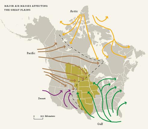
Once the westerlies get past the mountains, there is nothing to stop them— except for the invisible resistance of other air masses. The prairies’ wide open spaces are a playground for the winds, drawing in not only mild, dry air from the Pacific but also colder and even drier air from the tundra and polar seas. As this Arctic air floods south, it meets moist, tropical air flowing north from the western Gulf of Mexico. A typical weather diagram for the Great Plains would show Arctic air pushing down from the north, tropical air swinging in from the south, and wrung-out Pacific air wedged between them like the point of an eastward-facing arrow. Arctic air dominates in the winter, sometimes forcing itself all the way to Texas as a stinging “blue norther” and, occasionally, pushing on south to the isthmus of Tehuantepec at the very tip of Mexico. In the spring, the balance of power is reversed, as the gulf air mass gains strength and surges north, sometimes carrying tropical heat and humidity all the way up to the Canadian prairies. The rained-out Pacific westerlies, with their meager stock of moisture, make themselves felt throughout the year, especially during the dry months of fall and winter.
In spring and summer, in particular, this picture is complicated by an influx of warm, dry-as-bone air that blows across the southern plains from the southwestern deserts. The interplay of these “four strong winds” produces the distinctive precipitation patterns of the Great Plains grasslands. For instance, winter is a relatively arid season across most of the plains not only because cold air cannot hold much moisture but also because of the strong seasonal influence of dry air from the north and west. As a rule, less than one-third of the year’s precipitation falls between October and March, when these air masses exert their strongest influence. The other roughly 70 percent of the year’s moisture is received during the April-to-September growing season. Without this well-timed gift, the Great Plains would be a prickly expanse of cactus and other desert plants.
Much of the all-important spring-and-summer rainfall is generated when tropical air surges north and runs into Pacific and Arctic systems moving across the prairies to the east and south. Where the air masses collide, the lighter, warmer air from the tropics is forced up, cooling as it climbs, condensing to form clouds, and ultimately losing its moisture as general rain showers. Violent thunderstorms also frequently develop along these collision zones, or fronts, as the unstable tropical air rises up into towering, super-energized cumulonimbus clouds that glower over the landscape before releasing their humidity as hail or pounding downpours.
Because the contending air masses often meet in midcontinent, frontal thunderstorms are most common in the middle of the plains, in and around Colorado, Wyoming, South Dakota, Nebraska, and Kansas. But storms can also develop locally, without the clash of opposing weather systems to set them off. All it takes is a mass of warm, moist air and something to send that air spiraling up through the atmosphere. This lift-energy usually comes from the summer sun, which blazes down through cloudless prairie skies to heat the ground. Heat then radiates out of the soil into the surface air, causing it to rise, rotate, and mount upward to form a rain-filled thunderhead. In the dry western plains, one-third of the year’s precipitation can fall in a single hour from one of these spectacular cloudbursts.
> TORNADO ALLEY
For a person who craves the excitement of “active weather,” there is no better place to be than out in the middle of the broad prairie. The violent interplay of winds from the west, north, and south, complicated by occasional blasts of desert air from the southwest, all sheering across each other at their own heights and speeds and brought to a boil by the summer sun, builds up into magnificent thunderheads that rumble and spit bolts of fire across the grasslands. Not infrequently, these storm centers grow into supercells that pelt the Earth with hail, a hazard that can strike anywhere but that is especially prevalent in west-central Alberta and the central U.S. plains, in a large arc round and about Cheyenne, Wyoming.
When thunderstorms get especially riled up, they occasionally produce whipping tentacles of wind that, more occasionally yet, reach down to the ground and churn across the landscape as tornadoes. Although always rare and exceptional, tornadoes are nonetheless much more common in North America than anywhere else on Earth, with most reports coming from the southeastern United States and the Great Plains. Among the regions with the highest incidence of twisters is “Tornado Alley” in the southern plains, a zone that extends from Texas and Oklahoma, into western Missouri, and north through Aunt Em’s farm in Kansas.
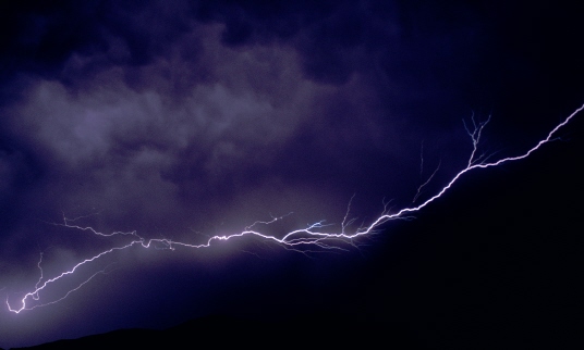
A severe thunderstorm crackles over the hills of Grasslands National Park, near Val Marie, Saskatchewan.
Global “Teleconnections”
By and large, the prairie climate is reliably unreliable. As the rival air masses interact with each other over the plains, they keep the atmosphere in a state of more-or-less-constant flux, so that the weather oscillates from extreme to extreme. But there are also times when the climatic system seems to get stuck. “Wet spells,” for example, when the rain refuses to stop. “Dry spells” of months— or years—when the clouds seem dry as parchment and the air fills with dust.
These persistent weather patterns also tend to be widespread, affecting significant parts of the Great Plains for prolonged periods. The droughts of the 1930s, for example, occasionally flared out to singe the entire continent, but they were at their most intense across the Great Plains grasslands. Some parts of the High Plains in Oklahoma and Texas experienced eight consecutive years of drought, between 1933 and 1940. Then, little more than a decade later, the central and southern plains—from the Mississippi to the Rockies and from Colorado to Texas—were again stricken by a severe drought that persisted from 1952 to 1957. The Canadian Prairie provinces were hit hard in 1961. Then, in the late 1980s, a three-year drought parched the entire northern plains and fuelled disastrous forest fires in Yellowstone National Park. During the growing season of 1988, when the crisis was at its worst, many parts of the prairies were hotter and drier than they had been at any time during the Dirty Thirties.
Yet five years later, some of these same areas were in full flood, as torrential rains pounded the western Midwest and sent both the Missouri and the upper Mississippi rivers spilling over their banks. By the time the waters receded, twenty-six people were dead.
Why do the prairies suffer these violent climatic spasms? Part of the answer to this question may lie halfway around the world, in a region somewhere between Australia and Peru. There, in the equatorial waters of the South Pacific Ocean, weather patterns that will eventually affect the prairies begin to brew. Recent research suggests that there is a link between the surface temperature of the South Pacific and the amount of precipitation that falls on the Great Plains, particularly during the winter and early spring.
So far, no one knows exactly how all the complex linkages in this global “teleconnection” work. But by rushing in where angels fear to tread, we can sketch a plausible, if simplified and speculative, narrative. When surface currents in the equatorial South Pacific are unusually warm—during a so-called El Niño event—huge volumes of water evaporate from the ocean into the air. When this massive upwelling of warm, moist air spirals into the atmosphere, it stirs up the circulation so energetically that the airflow over North America is affected. As the air masses swirl into new alignment across the continent, a persistent low-pressure system may eventually develop somewhere over the southern Great Plains. Since air flows toward areas of low pressure, this Low acts as a kind of pump that sucks in humid air from the gulf. Moist and warm, heavy with rain, this tropical influx delivers tons of precipitation onto the southern plains.
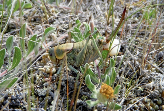
The cruel-looking spike on the rear of this female Mormon cricket is actually an egg-laying organ, or ovipositor. Although she does her best to protect her eggs by burying them underground, the outcome really depends on the weather. A cool, wet season means a poor hatch, while a warm, dry spring brings the reward of numerous offspring.
Candace Savage photo
Farther north, on the Canadian prairies, the effects are reversed, as El Niño heralds unusually mild winters and dry spring weather. But when the surface currents in the equatorial South Pacific are exceptionally cold—when La Niña sets in—the northern plains are likely to be frigid and buried deep in drifts.
But global influences, however stupendous, are not the only factors at work. Often, extreme conditions linger on the Great Plains long after the systems that triggered them have dispersed. A wet spell seems to breed more wet weather; a dry spell appears to breed more drought. But how could weather patterns possibly perpetuate themselves? The answer turns out to be surprisingly obvious. When precipitation is plentiful, water accumulates in the soil. As plants draw on this moisture to grow, they release water vapor into the air. This water vapor, in turn, combines with humidity that has evaporated directly from the earth, and these exhalations rise together to form clouds. Thus rain in the soil begets rain showers. What’s more, both rainfall and evapotranspiration (the release of water vapor from plants) have a cooling influence that helps to moderate temperatures and keep the evaporative demand within comfortable limits.
But following a prolonged dry spell, the cycle grinds to a stop. Plant growth slows and the rate of transpiration declines. So too does cooling evaporation from the soil. The ground and the surface layers of air sizzle in the sun, as a hot, dry land gets hotter and drier. (A case in point is the drought of the 1930s, which seems to have been intensified and prolonged by farming methods that left the soil exposed to the parching wind and robbed the system of what little moisture it held.) Eventually humid air from the south or the west returns to the scene, bringing welcome relief and restoring the climate to its own eccentric sense of normalcy.
> YOU CALL THAT A DROUGHT?
The Great Plains grasslands—and the climate that defines them—have been around for the last 8,000 to 10,000 years, ever since the last retreat of the glaciers. In the early days of this regime (from about 8,000 to 4,000 years ago), the climate was considerably warmer and drier than it is today and even more prone to drought. But sometime in the last few thousand years, the system took a turn toward cooler, moister norms, so droughts have ever so gradually and erratically become less frequent.
In fact, it seems that the past century (from 1900 to 2000) was the wettest in 2,000 years. This conclusion is based on studies of microscopic fossils found in lake beds across the northern plains, in Alberta, Saskatchewan, and North Dakota. By extracting core samples from lake bottoms and studying the types of fossils that are found at different depths, researchers are able to estimate the salt content of the water at different times in the past. Since salinity increases as water levels drop, these findings give them a measure of past droughts. At Humboldt Lake in central Saskatchewan, for example, the fossils bear mute witness to a severe drought—as bad as that of 1988—that persisted unbroken for more than seven decades. (On the southern plains and in the desert U.S., researchers have uncovered evidence of prehistoric droughts that persisted for up to 300 years.) Overall, it is clear that the droughts of the last century have been nothing compared with the intense and prolonged aridity of preceding millennia.
Could the prairie climate someday revert to its fierce old habits? Climatologists say that this is not only possible but quite likely. Scenarios for global warming (the anticipated shift in the climate due to the greenhouse effect) suggest that the Great Plains will experience higher summer temperatures and more frequent and extreme droughts, and that these effects will become increasingly evident within the next fifty years. Already, ecosystems around the world are showing signs of change, with earlier dates for flowering, emergence of insects, and egg-laying. And across the northern and central Great Plains, average annual temperatures are on the rise—up about 2.2˚f (1.2˚c) in some localities, in the last fifty to a hundred years—as the prairies ride the leading edge of global warming.
Gradients of Grass
These prolonged episodes of drought (many of them “forced” by events halfway around the world) have been the making of the Great Plains grasslands. Drought sucks moisture out of the soil, beginning at the surface and gradually burning farther down. If a dry spell is brief, the deep stores of moisture remain untapped, but if the evaporative demand persists, even the subsoil becomes parched and cracked. As a result, deeply rooted trees can cope without rain for several years by drawing water from underground, but they are doomed to defeat when drought reaches their root zone. Meanwhile, the grass lies patiently around the dying trunks, ready and able to spring back to life when the new rains finally come.
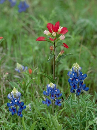
Taking full advantage of a well-timed spring rain, Texas bluebonnets and Indian paintbrush blaze along a roadside near Llano, Texas.
Long-term patterns of precipitation not only determine whether the land will grow trees or grass but also establish the limits that distinguish one “type,” or ecoregion, of grasslands from the next. When precipitation and other variables are averaged over the long term, the underlying order of the prairie climate begins to emerge. In the textbooks, these hidden patterns are revealed through charts and maps, but out on the prairie, they are written as gradients of grass.
Sometimes, the dialogue between the vegetation and the climate is intriguingly complex. For instance, summer precipitation on the prairies depends, in large part, on air masses that blow in from the south, carrying moisture from the gulf. Because of their southerly origins, these winds naturally have a greater influence on the southern plains (where they “reside”) than in the north (where they merely “visit”). So it isn’t entirely surprising to discover that the southern plains receive significantly more moisture than the northern prairies do. If, for example, Amarillo can hope to get 20 inches, or 500 millimeters, of moisture in a normal year, Lethbridge typically has to make do with only three-quarters as much. With this difference in mind, one might expect the prairies of northern Texas to be lusher than those of southern Alberta or Saskatchewan. Instead, the reverse is the case.
The trick is that the south-to-north gradient in precipitation is canceled out by an equal but opposite north-to-south gradient in evaporation. Because the average annual temperature increases from north to south, so does the rate at which moisture is lost through evaporation. Whatever the southern plains gain as rain, they lose as water vapor. As a result, the “effective precipitation”— the amount of water that is available to growing plants—is about the same in southern Alberta as in northern Texas. This helps to explain the long, gradual transition from the semiarid climate of the Northwestern Short/Mixed Grasslands to the sun-frazzled conditions of the Southern Short Grasslands. (A map showing these ecoregions can be found.)
Meanwhile, there is yet another climatic gradient that also helps to shape the vegetational profile of the Great Plains. This is an east-to-west decline in average annual precipitation. The tropical air that brings summer rains to the prairies typically swings up from the Gulf of Mexico, through the central United States, and off toward the east. As a result, its influence is stronger on the tall grasslands of the eastern plains than on the short-to-mixed grasslands farther west. If Winnipeg receives about 20 inches (500 millimeters) of moisture on average, Lethbridge gets 20 percent less (just 16 inches, or 400 millimeters). And if Kansas City can count on almost 40 inches (1 meter) of precipitation in a normal year, Amarillo can only expect to receive about half as much—and this time there is no reverse gradient in temperature to compensate for the difference. Less moisture is simply less.
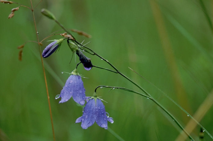
Raindrops cling to the translucent petals of a harebell, a flower that is native not only to the northern Great Plains but to parts of Europe as well, where it is famous as the bluebell of Scotland.
In the days before the prairies were plowed and settled, this east-west moisture gradient found expression in the natural vegetation. As the average precipitation declined toward the west, the vegetation diminished in step, gradually reducing in height like a living bar graph. Somewhere around 100 degrees west longitude (give or take a few degrees), the tall-grass species dwindled away, leaving the wind to ripple through knee-high stands of mixed-grass prairie. To the west and southwest, the midheight grasses in turn gave way to a carpet of ground-hugging grasses, as a dry land clothed itself in drought-resistant plants.
The boundaries between tall-, mixed-, and short-grass prairies are not as tidy as they look on the map. In the patchwork quilt of the grasslands, each of the major blocks of vegetation is composed of many smaller blocks. And just as the overall picture is determined by large-scale climatic patterns, so each of these distinctive patches is a response to local variations in microclimate. Conditions are different on a south-facing slope than on the north and on lowlands than on hilltops, and these subtle differences are reflected in the vegetation. Moving uphill, from humid bottomlands to the drier crest, reproduces the moisture gradient of moving from east to west. And so, a sea of tall-grass prairie is broken by islands of mixed (or even short) grasses that grow on uplands and arid slopes. Meanwhile, out on the short-grass prairie, blue grama and its diminutive associates follow the opposite trend, ceding ground to mid-height or tall grasses in moist valley bottoms.
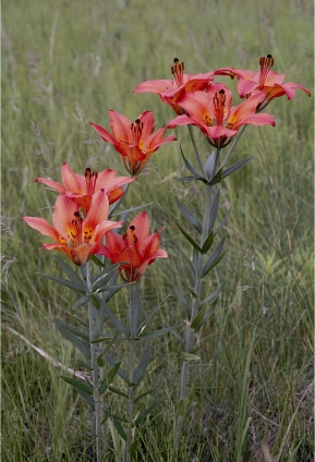
Western wood lilies scarcely put in an appearance during dry years but burst into a riot of color when the rains return.
Arthur Savage photo
Whether considered locally or regionally, the transition zones between the different “types” of prairie are dynamic, migrating upslope and down-slope, east and west, following changes in the climate. During periods when the weather is unusually wet, the tall and mixed grasses expand their influence and range, tracking the sweep of abundant rain. In times when the prairies are stricken by drought, the tall grasses are forced into retreat and the drought-resistant short grasses extend their reach. (During the Dirty Thirties, for example, the short-grass community pushed as much as 150 miles, or 240 kilometers, to the east, temporarily usurping the tall-grass prairie.) Thus, the grasslands keep time with the climate, mirroring its ebbs and flows and dancing to the erratic beat of the rainfall.
> PRAIRIE FIRE
Climate is the major factor that determines the extent of the Great Plains grasslands. To put it in technical terms, grasses hold sway wherever the evaporative demand (the amount of moisture that the atmosphere would draw away if it could) is slightly greater than the precipitation (the amount of moisture that is actually out there, in the ecosystem). But there is one important exception to this rule of thumb. The lush tall-grass prairies that fringe the eastern margin of the plains receive abundant moisture, more than enough to keep pace with evaporation. Theoretically, then, the region ought to support trees. And, in fact, wherever fragments of native tall-grass prairie have survived untilled, they have been aggressively invaded by stands of aspen, oak, and dogwood during the last 150 years.
The missing link—the force that maintained the tall-grass prairie in the past but that has since been all-but-extinguished—is fire. Prairie fire was the terror of the early settlers, a rapacious enemy that raced across the plains, leapt over firebreaks and rivers, and at times sped from horizon to horizon in a single day. But alarming as it was to humans, wildfire was a friend and ally of the tall grasses. Not only did it clear away the thick thatch of dead vegetation that prevented new shoots from breaking through, it also killed trees, the true “terror” of the prairies. When a tree burns, the growth points on its twigs and branches are likely to be injured, so the plant is hampered in its ability to produce new shoots. But a grass protects its growing tips under the ground, where the fire cannot reach, and rises from the flames like the proverbial phoenix.
Before the agricultural era, most parts of the tall-grass prairie were probably set ablaze once every three to ten years, either by lightning or by the deliberate action of Native people, who used fire to green up the prairie and bring in animals. But however prairie fires started, they always had the same effect: they were the guardians of the tall-grass prairies.
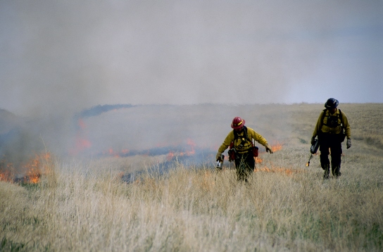
Controlled burning is used to maintain the health of tall grasslands, like this one in Badlands National Park, South Dakota.