Trip 49
PINE VALLEY
LENGTH AND TYPE: 12-mile out-and-back
RATING: Moderate
TRAIL CONDITION: Passable to difficult, poison oak
HIGHLIGHTS: Tall ponderosas amid an open meadow, ancient sandstone cliffs, buttes, and boulders, and Pine Falls, which cascades 50 feet into an emerald swimming hole
TO REACH THE TRAILHEAD: Park at the large turnout on Tassajara Road across from China Camp. The trailhead is on the camp side of the road, 100 feet south of the parking lot and 150 feet south of the camp entrance. The trail begins on a saddle above China Camp. It is marked, though encroaching brush often obscures the sign. There’s no water at the trailhead.
TRIP SUMMARY: This trail leads past old-growth pine forests, waterfall oases that shelter deep swimming holes, and wildflower-strewn meadows that remind one of the Sierras. Naturally, this is a popular year-round day hike, so it’s best to avoid it during major holidays. Though the valley lies within day-hike range, allow at least six hours for the round-trip to enjoy the scenery or visit Pine Falls for a refreshing swim. The route is ideal in spring and fall, as temperatures are moderate and storms infrequent. Summer temps can reach the upper 90s Fahrenheit, and flies and mosquitoes pose a nuisance. Winter temps can dip below freezing, and snow is common above 4000 feet. If your timing is perfect, however, between winter storms the valley can hit the upper 60s Fahrenheit, and you’ll likely have the valley all to yourself.
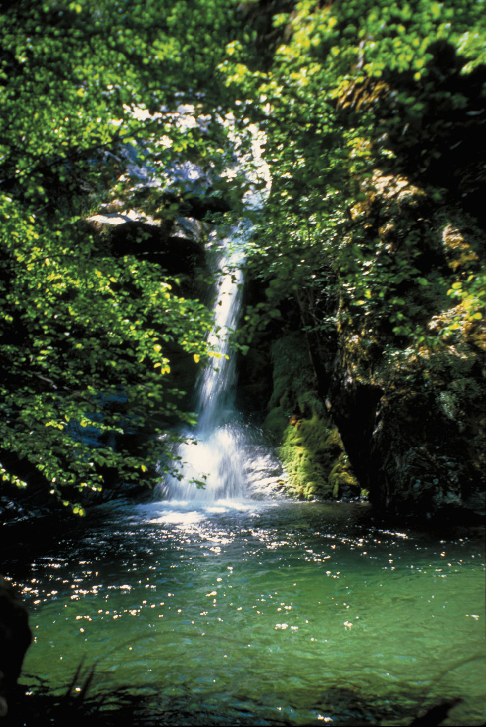
Pine Falls cascades 50 feet into an emerald swimming hole below Pine Valley.
Trip Description
The route begins at a marked trailhead on a major saddle above China Camp (4350'), 6 miles from Pine Valley and 24 from Big Sur. Like most trails in the Ventana Wilderness, this one is not regularly maintained. In 1999 fire scorched the area, allowing fire-adapted species to thrive. As a result, trail sections over the first 1.2 miles are heavily overgrown. You’ll gradually climb 400 feet, then descend the same elevation through shoulder-high brush dominated by ceanothus and tanoak.
In 0.6 mile you’ll emerge from the worst of the overgrown sections at the route’s high point (4750'). Views stretch south to the Black Cone Trail ridgelines and the Church Creek and Tassajara Creek drainages, west along the Coast Ridge, and southeast toward Cone and Junipero Serra Peaks. Rising nearly a mile above the Pacific, Cone Peak is perched atop the farthest visible ridge, 17 miles south. Dominating the horizon, 5862-foot Junipero Serra rises high above the unseen Salinas Valley.
The trail gradually descends a scenic ridge across golden grasslands and past thickets of new growth sprouting from the remains of a charred forest. The ridge separates the Miller Creek drainage and the Church Creek drainage. You’ll continue through oak woodlands and grasslands speckled with stalks of Our Lord’s candle, top a minor saddle, and climb the ridge to a prominent saddle. Views vanish briefly as the trail switchbacks southwest and then climbs north to the second highest point along the route (2.1 miles, 4740'). From here the route is all downhill to Pine Valley.
Pause for glimpses through the bare branches of burned snags. Look west to spot the sandstone formation that parallels Church Creek Fault. The trail turns southwest on a steep grade, dropping 850 feet through open oak woodlands carpeted with vibrant wildflowers in spring. After 1.5 miles the trail switchbacks down to Church Creek Divide (3.6 miles, 3650'). This divide marks the four-way junction of the westbound Pine Ridge Trail, the southeast-bound Church Creek Trail, and the northwest-bound Carmel River Trail to Pine Valley.
Forming a deep saddle between two west-trending ridges, the divide sits atop the 29-mile east-west Church Creek Fault. For millions of years the North American and Pacific plates have ground past one another, here creating Church Creek canyon. From the divide, the fault continues northwest, following the Carmel River Trail to Hiding Canyon Camp, ascending the Puerto Suelo Trail to the prominent Puerto Suelo saddle, and emerging at the Pacific near Kaslar Point. To the northwest lie the headwaters of the Carmel River, while to the southeast lie the headwaters of the Salinas River along Church Creek. Oddly enough, the latter winds some 80 miles north of the Carmel River before finding its way to sea.
From the divide, the Carmel River Trail turns right and leads 1.7 miles to the wildflower-strewn meadows and tall pines of Pine Valley. Over the first 0.3 mile you’ll cross the typically dry headwaters of the Carmel River. As the grade levels off (4.5 miles, 3160'), you’ll notice sandstone cliffs to your right and hear trickling water off to your left. The scene is reminiscent of the Sierras, with ponderosa pines rising from an open meadow beside steep sandstone cliffs.
You’ll continue through mixed evergreen and riparian forests, highlighted by rare endemic Santa Lucia firs at the valley’s east end. A large gate marks the official Pine Valley entrance (5.3 miles, 3140'), at a junction with the Pine Valley–Pine Ridge Trail and the cross-country trail to Pine Falls. The main trail leads to a year-round stretch of the Carmel River. If you have time, don’t miss the side trip to the falls.
SIDE TRIP
The 0.7-mile trail to Pine Falls is narrow, overgrown, and washed out in a few precarious places. Your payoff is a scenic waterfall oasis and swimming hole, among Ventana’s most spectacular sights.
From the Pine Valley–Pine Ridge Trail junction (5.3 miles, 3140'), turn left and cross the river, heading downstream a few yards before recrossing past the first of three small unofficial campsites. The trail closely follows the river, crisscrossing it multiple times on the way downstream past riparian forests and endemic Santa Lucia firs.
You’ll emerge at an overlook directly above 50-foot Pine Falls (6 miles, 2700'). The descent to its base is hazardous, as you must clamber across slick boulders. Use the conveniently placed rope to negotiate the final 20 feet through a minor gully. The crystal clear pool is wide and deep enough for swimming, but as temperatures only reach the high 50s Fahrenheit at best, your swim will be a quick one. Enjoy the brisk plunge and return the way you came.
If you’re bound for the more spacious upper meadow, turn right at this junction onto the Carmel River Trail, following a decrepit sign marked BEAR BASIN. You’ll pass through a gate toward a small cabin on private land. A longtime Pine Valley resident lives and gardens on the small plot to your right.
A hundred feet past the cabin you’ll ascend a minor knoll, then descend into upper Pine Valley and the official Pine Valley Camp (5.4 miles, 3200'), equipped with a fire ring and room for up to three tents. Six or seven unofficial campsites also lie nestled amid the pine-studded meadow, each equipped with a fire ring and room for up to three tents. These fill up quickly on holiday weekends.
Scamper up the valley walls at dawn or dusk for spectacular pine-filtered views, highlighted by grazing deer and active woodpeckers. If the valley is deserted, you may even hear the cry of a lone coyote or happen across the tracks of an elusive bobcat along the riverbanks.
PINE VALLEY NATIVES
For thousands of years, fertile Pine Valley was home to the Esselen people, providing them with excellent hunting, gathering, and living grounds. The Esselen may have used fire to clear underbrush and maintain the pine stands and broad meadow, where deer, rabbits, antelopes, and even bears once commonly grazed. In the adjacent forest, doves, quails, and other game birds flocked beneath the abundant canopy of oaks, bays, pines, and madrones. Wild roses grow in dense thickets on the east edge of the valley, perhaps cultivated by the Esselen for straight, strong arrow shafts. Beneath the sandstone cliffs, women took harvested acorns from the surrounding oak woodlands and ground the nutritious meat into flour. Their mortar holes still pepper sandstone outcrops just downstream from the Pine Valley–Pine Ridge Trail junction.
Today, few Esselen remain to answer the many questions one might have about their ancestors’ lives in Pine Valley or elsewhere along the Santa Lucia Range. Most of their people were decimated by disease brought by Spanish missionaries. Those who survived were often captured and sent to work in the Spanish missions. Others were killed without mercy. Sadly, much of their culture, language, mythology, and religion was also lost.