
Yes, it rains a lot—except for those months when it dries up altogether. Ours is a maritime climate greatly influenced by the largest body of water on the planet. Some things are simply beyond our control. Our mild winters and long springs are ideal for cultivating a variety of cool-season crops, many of which tolerate light frost. Summers, while warm, pleasant, and generally dry, rarely get hot enough to hinder plants that don’t do well in heat. True, occasionally we’ll struggle to ripen warm-season crops like tomatoes, peppers, eggplants, and corn, but we’ll always have kale and other hardy crops that produce in fall and over winter. This short chapter offers a layman’s overview of a maritime climate and introduces the notion of “climate cues” as they relate to garden planning.

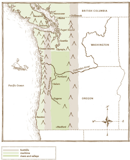
Influenced by mountain ranges and moderated by neighboring bodies of water, the PNW is divided into three dominant growing regions.
Knowing your area’s first and last frost dates, the seasonal bookends that determine the growing season, is a good gardening starting point. Frost dates are calculated by compiling and averaging several years of data collected at regional weather stations that often bear little resemblance to a garden—think airport tarmac not open soil. These days, “average” is an elusive concept as we all adjust to a new normal affected by climate change factors. Consider frost date data as flexible guidelines to work from when planning the growing season.
AVERAGE FROST DATES FOR THE PNW
CITY | FIRST FROST | LAST FROST |
Washington |
|
|
Blaine | 10/18 | 4/19 |
Seattle | 11/17 | 3/10 |
Olympia | 10/6 | 5/5 |
Ocean Shores | 11/18 | 4/1 |
Oregon |
|
|
Portland | 11/15 | 3/23 |
Eugene | 10/19 | 4/22 |
Medford | 10/20 | 4/27 |
Bandon | 11/16 | 4/2 |
British Columbia |
|
|
Chilliwack | 11/9 | 4/6 |
Nanaimo | 10/17 | 4/28 |
Vancouver | 11/5 | 3/28 |
Victoria | 11/5 | 4/19 |
(United States chart data from National Climatic Data Center, US Department of Commerce; Canadian chart data from Environment Canada.)
A map, rather than a chart, offers a better perspective on growing conditions in western Washington, western Oregon, and southern British Columbia. Mountain ranges and neighboring bodies of water influence the three distinct PNW growing regions: foothills, maritime, and rivers and valleys. Like first and last frost dates, temperatures listed for each growing region are averages based on several years of data. Actual conditions and severe weather events are to be expected. Global warming and climate change—and the resulting extreme temperatures, stronger winds, and heavy rain—require PNW gardeners to monitor conditions and be prepared to adapt; something that comes naturally to this weather-watching corner of the country.
Growing season: 150 to 200 days
Average winter temperatures: 34 to 28°F
Average summer temperatures: 60 to 70°F
The Pacific Coast Ranges includes the Insular Mountains of Vancouver Island, the Olympic Mountains along the Washington coast, and the Coast Range which continues down through Oregon into northern California. The Cascade Range, characterized by tall volcanic peaks and deep valleys, cuts through central British Columbia, Washington, and Oregon and is responsible for the dramatically different climates dividing the PNW into western and eastern growing regions. The foothills growing region enjoys a long frost-free growing season but lacks the heat to mature warm-season plants without additional protection or starting from transplants.
Growing season: 200 to 250 days
Average winter temperatures: 30 to 40°F
Average summer temperatures: 65 to 70°F on the Pacific; 70 to 75°F along inland waterways
Neighboring saltwater defines this growing region that includes the coasts of Washington, Oregon, and southern British Columbia, as well as the Puget Sound Basin located about 75 miles inland from the Pacific coast. North of the Canadian border, Puget Sound branches into the Strait of Juan de Fuca heading west toward the open Pacific and the Strait of Georgia to the east of Vancouver Island, an especially moderate region that’s known as the Sunshine Coast. Stable water temperatures throughout the year modify the climate with cooling breezes in summer and warmer conditions in winter. Wind, fog, and cool air temper the luxuriously long growing season and heat accumulation is slow.
Growing season: 155 to 280 days
Average winter temperatures: 33 to 40°F
Average summer temperatures: 80 to 90°F
Buffered between the two mountain ranges and free from saltwater influence, this region enjoys the warmest summer growing conditions. Frigid continental air spilling down through the Columbia River Gorge where it empties into the Willamette River valley is responsible for cold winter conditions. Warm summers and chilly winters are ideal for cultivating fruit trees and berries (including grapes), while warm-season crops produce abundantly.
In 1960 the United States Department of Agriculture (USDA) devised a map dividing the country into ten hardiness zones (determined by average minimum winter temperatures) which soon became industry standard for most garden texts and plant labels. The updated 2012 USDA Plant Hardiness Zone Map has improved computing models which take into account elevation, slope, and the moderating influence of neighboring bodies of water. This highly nuanced, interactive online map allows you to more accurately pinpoint where your garden falls within the system simply by entering your zip code (planthardiness.ars.usda.gov/).
According to the USDA Plant Hardiness Zone Map, western Washington and Oregon fall within zones 7a (0°F) along the Cascade foothills to 8a (10 to 15°F) and 8b (15 to 20°F) in coastal regions and around the Puget Sound basin. In what seems a bizarre comparison Tallahassee (Florida), Seattle, and Portland are all listed zone 8b, while Dallas (Texas), Medford, and most of the Washington coast are all zone 8a. Not so much a flawed system, just difficult to apply to our unique region.
If climate is regional, microclimate is where you live. A microclimate is a localized pocket of unique weather modified by adjacent buildings, bodies of water, terrain, and wind pattern. Cold air flows like water down a slope and pools at the bottom forming a frost pocket where winter may linger hours, days, or weeks longer than a garden plot upslope. Buildings, fences, and hills provide shelter from chilling winds, while paved and masonry surfaces serve as heat banks, absorbing the warmth of the sun during the day and releasing it at night to keep adjacent garden beds a few degrees warmer.
My garden is about half a block from Puget Sound and protected to the north by a small hill. This large body of saltwater and topography mean that my yard is one of the last places in the greater Seattle area to receive frost, snow, or freezing conditions. Many times I’ve set out in the rain only to discover snow a few blocks away.
Not only do microclimate conditions vary from yard to yard, but they can even vary within a garden. Careful observation will reveal existing microclimates at play in your garden; watch where early weeds germinate to find which part of your garden warms up first. Prevailing winds—even a light breeze—cool the garden and could very well cost you flavorful tomatoes, ripe melons, and mature corn. Manipulate microclimate conditions by installing a stone wall, hedge, fence, or other windbreak, and by choosing building materials like concrete, stone, and brick to trap and retain heat.

KIDS WILL BE KIDS
PNW weather is affected by the climatic conditions known as El Niño (little boy) and La Niña (little girl). These patterns, which represent a shift from the norm, are influenced by surface water temperatures in the Pacific. El Niño conditions bring on warmer and drier winters, while La Niña produces cooler and wetter weather. In years past, El Niño has robbed us of seasonal snowpack resulting in water shortages during the following summer dry period. In contrast, the cold wet winters of a La Niña system, while heaven for skiers and boarders, foster headlines that read “Snowpocalypse” as white-knuckled lowlanders try and navigate icy hills and bridges, bemoaning the loss of their otherwise hardy plants. Given the proximity of the Pacific, “the kids” are a fact of PNW life, gardening and otherwise. I find it helps to think of them as a continuum—and embrace change.
When climate chaos and calendar collide, look to the natural world for cues as to how the season is progressing. Farmers and gardeners throughout history have relied on patterns and rhythm rather than weekends and holidays. The observation of recurring stages of plant and animal life and their timing relative to weather and climate is called “phenology.” A caterpillar, for example, waits to emerge until the plant on which it feeds leafs out; and birds delay nesting until nature serves up a caterpillar meal to nurture their young. This elegant system is based on the appearance of a particular plant, which is mostly likely determined by rising soil temperature—that universal gardening gun shot that signals the start of each growing season.
Folklore and farm wives are full of gardening truisms like “plant spinach, lettuce, and peas when lilacs show their first leaves.” But like the USDA hardiness zone map, what works in Portland, Maine, doesn’t necessarily hold true in Portland, Oregon. Practice a little citizen science by keeping a garden journal to track what blooms when; what the weather was doing at that time; and the corresponding appearance, or disappearance, of backyard birds and insects. Over time you’ll accumulate a picture of the very unique seasons found in your own backyard and a series of valuable reminders that when you see this happening in the natural world it’s time to do that.