
t View over Aracaju, which sits at the mouth of the Rio Sergipe
t View over Aracaju, which sits at the mouth of the Rio Sergipe
In 1855, Sergipe’s capital moved to Aracaju, situated at the mouth of the Rio Sergipe; by 1901, the sleepy fishing village had transformed into a stately capital.
Today, Aracaju is a large city with a commercial downtown area along the south riverbank. Sea-life enthusiasts should visit Oceanário, which has models of various marine habitats, plus sea turtles and a shark tank. Another of the city’s top attractions is the Museu da Gente Sergipana, a museum exploring the history, culture, and traditions of the Sergipe region.
Aracaju’s lively beach neighborhoods lie 6 to 12 miles (10 to 20 km) south of the city center. The most popular suburban beach is Atalaia, with its recreation facilities, cultural events, and seafood joints.
"
⌂ Av Santos Dumont 1010 § (79) 3214 3243 # 9am–9pm daily
"
⌂ Av Ivo do Prado 398 § (79) 3218 1551 # 10am–4pm Tue–Fri, 10am–3pm Sat & Sun
The name Aracaju comes from the Tupí-Guaraní words meaning “the cashew tree of the parrots”.
A designated National Historic Heritage Site, São Cristóvão was founded in 1590, and is considered one of the oldest cities in Brazil. It served as the capital of Sergipe in the 17th and 18th centuries, but when the capital shifted to Aracaju it soon dwindled to the sleepy interior town it is today.
The town’s charming historic center is a panoply of colonial squares and buildings, and is also a hub of commerce. The most beautifully preserved square, Praça de São Francisco, is easily identified by the large Franciscan cross at its center. Here, the Museu de Arte Sacra (Museum of Sacred Art) has a fine collection of silver chalices, and a few beautifully sculpted statues of saints.
"
⌂ Praça de São Francisco § (79) 3261 1385 # 10am–4pm Tue–Sat, 10am–1pm Sun
The oldest settlement in Alagoas, Penedo was founded in 1565 on a strategic bluff overlooking the Rio São Francisco, about 19 miles (30 km) upstream of the delta. Today, Penedo’s historic center has been designated a National Historic Monument. Particularly noteworthy is the complex housing the Convento de São Francisco and Igreja de Santa Maria dos Anjos, built over a period of 100 years.
The Igreja Nossa Senhora da Corrente, built in 1765, was used by enslaved people as a refuge.
⌂ Rua 7 de Setembro 218 # 8–11:30am, 2–5pm Tue–Fri, 8am–11pm Sat & Sun
'
⌂ Praça 12 de Abril # 8am–4pm Tue–Sun

t Igreja Nossa Senhora da Corrente overlooking the Rio São Francisco
The largest and most vital river in the region, the Rio São Francisco has long served as the irrigation lifeline and main transport link for the people in the small towns of the arid northeastern interior to the bigger cities along the coast. Considered a symbol of national unity, Brazilians revere the São Francisco, and it is the subject of many myths and fables. The 1,760-mile (2,830-km) river meanders through five states. Originating in the Serra da Canastra mountains in Minas Gerais, it flows north through Bahia, and crosses briefly into Pernambuco before continuing east, marking the border between Sergipe and Alagoas in its final run to the sea.
Experience Sergipe, Alagoas, and Pernambuco

t STATUES OF THE BONITAS
In the 1920s and 1930s, bandit leader Lampião and his wife Maria Bonita led a band of 40 outlaws, nicknamed cangaceiros (cangaço means badlands), on a 15-year spree of robberies, hold-ups, and shoot-outs across the northeast. As their raids continued, the Bonitas became notorious figures throughout Brazil. The police and militia searched for them endlessly but were unable to capture them. Finally, in 1938, Lampião, Maria Bonita, and nine cangaceiros were ambushed and killed by the police in Sergipe.
Standing on the Rio São Francisco, the Xingó Dam in Sergipe is one of the largest in Brazil. When it was completed in 1994, the dam blocked off the São Francisco canyon at a point about 155 miles (250 km) from the ocean, causing the river to rise and create the Xingó Reservoir (now a destination itself).
Catamarans and schooners depart from the dam and travel upstream, crossing the reservoir and re-entering the main part of the river.
Situated 2 miles (3 km) from the dam, the Museu de Arqueológia de Xingó displays numerous archaeological objects from nearby sites that were flooded when the dam was created. Objects from the earliest sites, dating from around 5000 BC, include rock paintings, stone mortars, and fish-cleaning tools.
' "
⌂ 2 miles (3 km) from Xingó dam at Rodovia Canindé-Piranhas, Trevo da UHE Xingó, s/n § (82) 98849 2622 # 8:30am–5pm Tue–Sat (to 4pm Sun)

t The stately Convento do São Francisco in Marechal Deodoro
The capital of Alagoas until 1839, Marechal Deodoro was founded in 1611 as Vila Madalena. The city’s name was changed in honor of its native son, Marshall Manuel Deodoro da Fonseca (1827–92), elected as Brazil’s first president in 1891. Fonseca’s childhood home is now a small museum, displaying original furniture.
The city’s 18th-century colonial center features the Rococo Igreja de Santa Maria Madalena. Adjoining the church, the Convento do São Francisco houses an interesting museum.
⌂ Praça Pedro Paulinho § (82) 3263 1623 # 10am–4pm Wed–Sun
⌂ Rua Dr Melo Morães 1–117 # 9am–5pm Mon–Sun
Porto de Galinhas is one of the most popular tourist destinations in northeast Brazil, and deservedly so. There are no high-rises dwarfing the beach here, just low-scale pousadas and bungalows. The star attractions of the area, in addition to the beach, are the natural tide pools that form in the reefs just a short distance offshore. Colorful jangada rafts take swimmers and snorkelers out to the clear shallow waters that teem with tropical fish.
Porto de Galinhas also offers a lively atmosphere with excellent restaurants and shopping, and, better still, it does not take much effort to get away from the bustle. A short distance south along the beach leads to Ponta de Maracaípe, a beautiful spot with a large white sandbar, where the Rio Maracaípe runs into the ocean.
Experience Sergipe, Alagoas, and Pernambuco
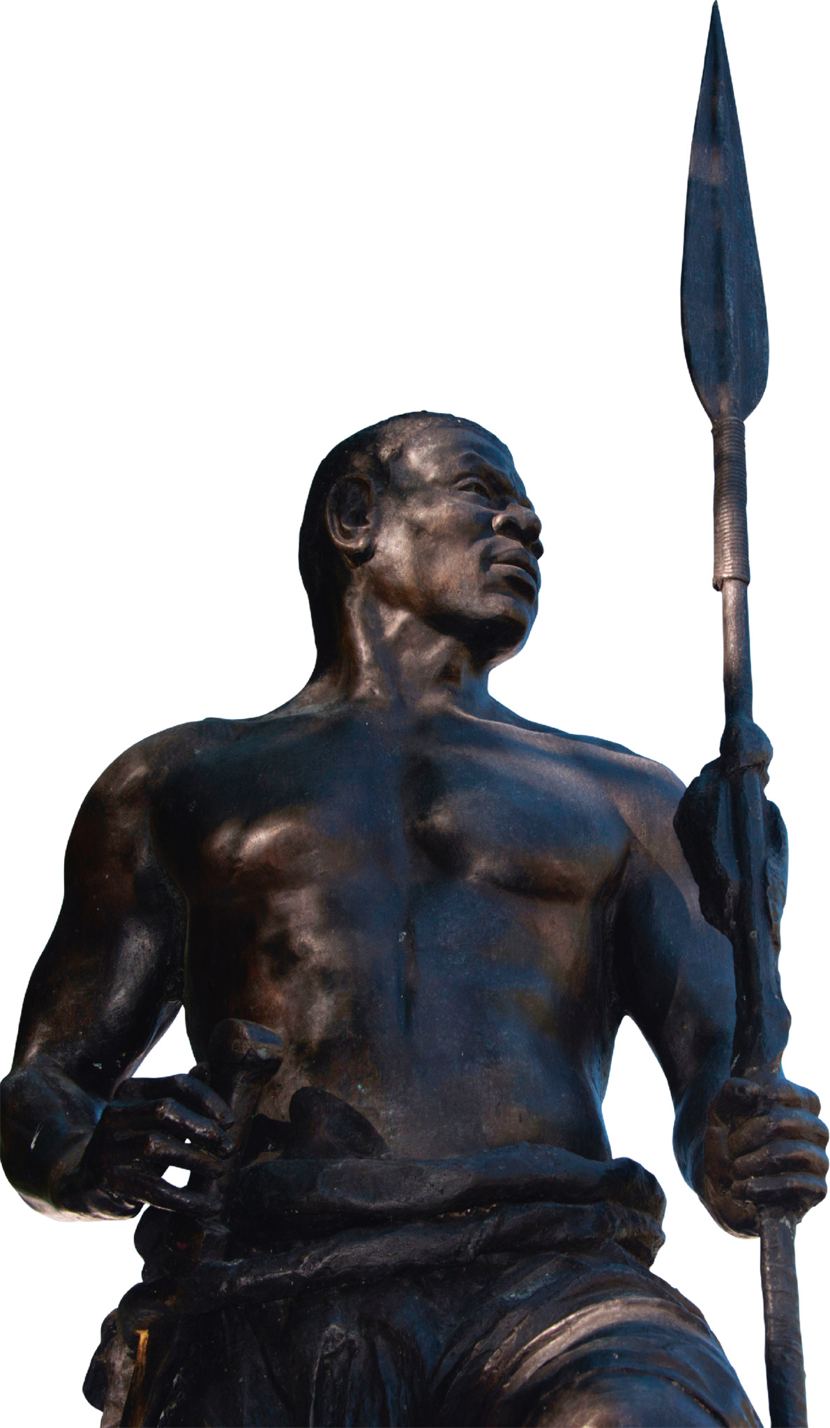
t A STATUE OF ZUMBI
In the African Yorubá language, quilombo means dwelling place. In Brazil, the term was used to describe a community of runaway enslaved people. Brazil’s most famous quilombo was Quilombo dos Palmares in Alagoas. In the late 1600s, Zumbi, the quilombo’s second leader, successfully defended it from repeated Portuguese attacks. However, the Portuguese were relentless, and Palmares fell in 1694; Zumbi was beheaded and the community destroyed. Zumbi’s legacy is remembered every year on November 20, on Zumbi dos Palmares Day.

t Boats in the shimmering, tranquil waters off the coast of Maceió
The capital of Alagoas, Maceió is known for its many beautiful urban beaches. The best known, from north to south, are Jatiúca, Ponta Verde, Sete Coqueiros, and Pajuçara. Protected by reefs, the beaches have little or no surf, warm water, and a Caribbean turquoise-green color.
About 1 mile (2 km) offshore from Pajuçara, a series of coral reefs are partially exposed at low tide, forming natural pools that can be explored with a mask and snorkel.
In addition to the beaches, Maceió has a small historic core. One of the loveliest mansions on the waterfront houses the Museu Théo Brandão. Named after a local writer who wrote about Alagoan folk art and anthropology, the small museum has a good collection of local art.
The southern end of the city borders the Lagoa Mundaú, which encompasses several mangrove islands teeming with marine life.
' "
⌂ Av da Paz 1490, Centro § (82) 3214 1713 # 9am–5pm Tue–Fri, noon–5pm Sat & Sun
The island of Itamaracá played an important strategic role during the Dutch interregnum in Brazil. In 1631, the Dutch built the Forte Orange here to protect their new domain from invading forces. The Portuguese destroyed this in 1654 but created a new fort in stone on the site.
Just across from the fort is a small island, Coroa do Avião, which has natural reef pools. Boats to the island leave from the beach in front of the fort. Itamaracá is also home to the Projeto Peixe Boi, a manatee research and rehabilitation center. Manatees live along the Brazilian coast from Alagoas to Amapá, but scientists estimate that there are only around 400 animals in the wild along this coast. The center works to rehabilitate injured manatees. Unfortunately, it is closed to visitors until further notice.
"
⌂ Estrada do Forte # 9am–5pm Tue–Sun
Located on the mainland, 100 miles (160 km) southwest of Itamaracá, Caruaru is a town whose fame rests on its ceramic figurinhas (figurines). Artist Vitalino Perreira dos Santos (1909–63) made many of these painted sculptures, and his hometown, Alto de Moura, a community of potters located 4 miles (6 km) west of Caruaru, still specializes in producing figurines. Casa Museu Mestre Vitalino in Alto do Moura is dedicated to this artist, and displays his tools.
Caruaru’s open market is the largest in the northeast. Besides figurines, leather bags, straw baskets, and ceramic pots are also sold at some of the best prices in Brazil. In addition, Caruaru, known as the capital of forró, hosts Brazil’s largest month-long forró festival. The Museu do Forró Luiz Gonzaga pays tribute to Luiz Gonzaga, the father of forró music.
⌂ Rua Mestre Vitalino 281 § (81) 3725 0805 # 8am–5pm Tue–Sat, 9am–1pm Sun
⌂ Praça José de Vasconcelos § (81) 3721 2545 # 8am–5pm Tue–Sat, 9am–1pm Sun
Experience Sergipe, Alagoas, and Pernambuco
|
stay Meu Hostel This friendly, well-designed hostel is located just 150 meters from the beach. ⌂ Rua Senador Ezechias Jerônimo da Rocha 134, Cruz das Almas, Maceió ∑ meu-hostel.com \\\ Pousada Porto Verde Artistically decorated pousada in lush surroundings with lovely rooms and a generous breakfast. ⌂ Praça 1, Rua Caraúna s/n, Porto Galinhas ∑ pousadaportoverde.com.br \\\ |