6 The First Ascents
I have never met in all my experience of ascending mountains, one so difficult of access.
On a fine Sunday, 16 January 1853, the first recorded ascent of Frenchmans Cap was made by a party led by surveyor James Sprent. Unlike those before him, Sprent had not come to Frenchmans Cap in search of gold or new farming lands. He had come with one specific aim — to climb Frenchmans Cap and to erect a trigonometrical survey station on the summit.
James Sprent emigrated from Manchester, England, in 1830. A graduate of Glasgow and Cambridge universities, Sprent was aged 22 when he arrived in Van Diemen’s Land with enough capital to set himself up on the land. However, when his application for a land grant was declined he wasted no time in joining the Survey Department.
Sprent is best remembered today for his work on the trigonometrical survey of Van Diemen’s Land, which was later used as a basis for better mapping. The survey was a mammoth and costly undertaking which was carried out, with a 10 year interruption, between 1833 and 1853. The trigonometrical survey was heavily critised by James Calder and others, though it also drew praise.
What was beyond doubt, though, was Sprent’s dedication to the project. He climbed most of Tasmania’s highest peaks, often under extremely difficult conditions. He erected 206 trig stations, usually in the form of stone cairns, throughout Tasmania and many of these can still be seen today. A typical Sprent party was made up of about 10 convicts who assisted him in the more practical side of his survey work, such as building cairns, cooking meals and cutting paths through thick scrub.
Sprent’s party would often disappear for weeks at a time, seemingly swallowed up and forgotten in the high mountains and deep valleys of Tasmania’s wildest country. During this time their tents and clothes frequently fell to pieces and their rations ran out, forcing them to eat ‘carnivorous quadrupeds’. None of these obstacles appears to have distracted Sprent from the task at hand. Nevertheless, his survey work at Frenchmans Cap, carried out in the final year of the trigonometrical survey, appears to have been a particularly trying undertaking.
The first ascent of any mountain is a noteworthy event, particularly a peak as striking in form as Frenchmans Cap. For James Sprent, however, the approach, ascent and retreat from Frenchmans Cap were accompanied by nothing but hardship and misfortune. None of Sprent’s journals has survived to the present day, so there is no record to indicate the route he took to Frenchmans Cap, nor the names of those accompanying him.
Sprent left Marlborough on New Year’s Day 1853 and approached the peak from the east, following Calder’s track. ‘After experiencing the usual bad weather of this quarter I got upon the side of the Frenchman on the 8th, and by the 16th an object [cairn] was placed upon that mountain.’ It would appear that Sprent’s party may have run into difficulties. It took them over a week to get from Pickaxe Ridge to the summit, indicating that Sprent may have failed to locate the important ridgeline of the Main Range, requiring him instead to negotiate the intricate system of ridges, valleys and rainforests that surround and defend the approach to Frenchmans Cap.
I have never met in all my experience of ascending mountains, one so difficult of access. The spurs are very irregularly placed and preserve little continuity. They are riven asunder by chasms hundreds of feet deep, presenting a fearful abyss to the cautious traveller. I could not pass over them myself as I found my head not fit for such a dangerous service. My men, however, were able by great labour and coolness to pass through this ordeal, and their perseverance was crowned with success. I went with them as far as I could, and approached so near to the top as to hear and return the coo-eys of the men upon the top. From these features of the mountain it would be quite impossible to take the instrument upon the mountain, from the east side at least, and from the account given by the men, the west side of the mountain presents no better aspect, and I think I may safely come to the conclusion that angles cannot be taken from this mountain.45
Sprent had climbed as far as North Col, but no further. The honour of the first known ascent of Frenchmans Cap by white men rests with his party of convicts, their number and names now lost in time. Sprent’s men constructed a cairn on the highest point, using the abundance of quartzite rocks that littered the summit in every direction.
The stone cairn originally measured three metres square and stood 1.6 m high. It was surmounted with a column of pandanis (Richea pandanifolia) stems, which the men had harvested from stands growing around Lake Tahune, then laboriously carried up to the summit. His men also built a number of small cairns marking the best route up to the summit from North Col.46
The ‘instrument’ Sprent refers to was a Thoughton’s six inch theodolite, heavy and cumbersome, which he firmly believed could not be safely negotiated up the steep summit slopes. In any event, if angles were to be taken from the summit with a theodolite, Sprent’s report makes it clear he would not be the surveyor standing behind it.
Sprent’s letter is both a candid admission of his own failure to reach the summit and a glowing endorsement of the value of his men, issues which a less honest man could neatly have sidestepped using the wordy parlance of a formal departmental report. Sprent’s determination was tested even further when one of his tents caught fire and ‘all of my clothes and bedding were burned, except the things I had upon me, and some of the men’s things’.
Under these circumstances one could hardly have blamed Sprent had he chosen to abandon the survey forthwith and returned to Hobart Town. Instead, he advised the department that he would be proceeding directly to Mount Olympus, then to the Eldon Range and Wylds Craig to complete this section of the triangulation program. It was a measure of Sprent’s professionalism and resolve that he was able to put these setbacks behind him and continue his survey work.
The stone cairn built by Sprent’s men stood on the summit for over 120 years. It was dismantled around 1975 by a strong ‘green’ element who believed the summit should be returned to its natural state, a fate suffered by Sprent cairns on other Tasmanian mountains. Sprent was an excellent surveyor and a resourceful bushman, but years of arduous work in the bush and exposure to the elements ruined his heath; 10 years after his pioneering trip to Frenchmans Cap, Sprent was dead, aged 55. Although he never stood on the summit of the mountain that caused him so much frustration, today Sprent’s name is inseparably linked to Frenchmans Cap.
Tully, Spong and Glover
Four years after Sprent’s men erected the summit cairn, three men — Tully, Spong and Glover —recorded the second ascent of Frenchmans Cap. The trio left Hobart in December 1856 with the clear intention of finding gold. ‘The prospect of finding gold in profuse quantities on this famed mountain of quartz [sic] directed us thither,’ Charles Glover informed readers of the Tasmanian Mail in a reflective article published thirty years after the event.47 ‘A man to cook and keep us supplied with game, viz, kangaroo and badgers’48, was probably a former assigned convict.
In those days no road existed beyond the township of Ouse. From here, a cart and four oxen was used to complete a rough journey ‘beset as we truly found it with boggy creeks and quaking marshes’. The cart eventually became bogged in the wet button grass of the King William Plains, leaving the party to continue their journey on foot.
A wet and snowy night was spent sheltering on the slopes of Mount Arrowsmith, and next morning they made the steep descent down slopes ‘not agreeable to knapsack drill’. Eventually, a ‘permanent station’ was established beside the outlet from Lake Vera. Their journey so far had been a miserable undertaking dogged by persistent bad weather, ‘three-fourths being wet’.
We were now in the middle of the great mountain. The beautiful white quartz and gold began to look rather misty. We, however, were determined to give the mountain a fair trial and so sunk a hole 33 ft down to the rock green stone [dolerite], and after innumerable washings could not detect the slightest trace of gold. The appliances for sinking this shaft were a bucket made out of one of the knapsacks, badger skins, twisted rope, and windlass.49
The morning of the ninth of January 1857 brought fine weather at last. The party left early to climb the Cap by way of the steep ridge overlooking Lake Vera. This scrubby ridge narrowed progressively until they found their way blocked ‘by an immense boulder of some thousands of tons; this we had a little difficulty in crawling round. The block seemed to stand on a base of only a few feet and might have been easily toppled over.’ In 1978, this boulder tumbled from the Main Range and now straddles the track on the way up to Barron Pass. The party made their way around the ridge of the Main Range to Lake Tahune.
Unencumbered as we were excepting our lunch of badger and damper, we soon reached the top lake into which Mr Tully and I plunged, but were as quickly out again, this water, derived from the snow just above being as cold as water could be without freezing. A few hundred yards up a steep, sloppy, shingly bank brought us under the rim of the Cap [North Col]. Each of us had the notion of being the first to touch the Trig. Station, at the instance of which an event happened not soon to be forgotten by me. In my eagerness to be first I did not care to look for any proper place or pass, but dashed at the cliff in front of me. It was only when a few feet from the top that the horrors of my situation became apparent. To get back was impossible; knees, chin and elbows had to do their duty, and the top was gained after much exertion. My friends followed by the proper pass without much difficulty ... It appeared that the station on top had been built up with Richea stems brought up from the lake below, where they were growing. Mr Sprent’s men must have had a tough job.50
Charles Glover began collecting botanical specimens, and on the way back to Lake St Clair he ‘incautiously’ managed to get bitten on the finger by a tiger snake. Tully rendered the only first aid known for snake bite at the time by sucking the wound, but Glover was particularly fortunate that the snake’s fang had only torn the hard skin of the palm knuckle of his middle finger.
The party returned safely to the King William Plains, where with the help of local shepherds they managed to free their bogged cart. Glover appears to have suffered no ill effects from the snake bite, ‘although some of the shepherds standing by consoled me by saying I would live until sundown, and it certainly checked my gathering any more flowers that evening. However, I experienced no bad effects and at the time of my anticipated demise I relished a good platter of mutton chops.’
To while away the wet hours in their camp beside Lake Vera, Frederick Spong had cut a small branch from a lakeside sapling of Huon pine, upon which he carved their names and the date. This staff was carefully placed inside a small cairn built alongside Sprent’s trig station on the summit of Frenchmans Cap. Over the years Tully, Spong and Glover’s staff became part of Frenchmans Cap lore. It was uncovered and inspected by parties visiting the summit for nearly ninety years. In 1944, it was found by Jack Thwaites who, noticing it was deteriorating badly, took it to Hobart to lodge with the Tasmanian Museum and Art Gallery. The museum, however, has no record of the staff, though Jack Thwaites did have the foresight to photograph the relic. This photograph is now kept at the Tasmanian Archive and Heritage Office.
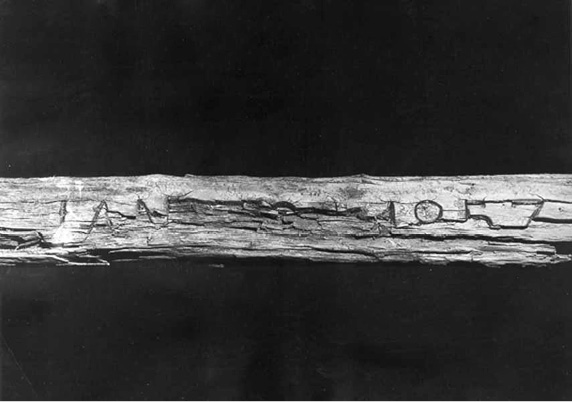
The weathered Huon pine staff carved by Frederick Spong which remained on the summit of Frenchmans Cap for over 90 years. (Tasmanian Archive and Heritage Office)
Although Tully, Spong and Glover (and probably their ‘man’) had succeeded in climbing Frenchmans Cap, their quest for gold brought no results. Still, Tully must have seen enough signs over that summer of 1857 to lure him back two years later to determine whether the Frenchmans Cap region really did contain gold.