16 The Frenchman’s Cap National Park
It is not possession of the land,
but of the landscape, that he enjoys;
and, as for that, all the wild parts of the earth are his,
by a title that carries
with it no obligation but that he shall not desecrate
nor lay them waste.
Horace Kephart (1862–1931)
Ray Livingston was a well-known member of the Hobart Walking Club. His family ran a dairy at the top of Red Chapel Avenue in Sandy Bay, but Ray’s daily work was as chief draughtsman for the Lands and Surveys Department in Hobart. In the 1930s, he and another Hobart Walking Club member, Marcus Gibson, made their first visit to Frenchmans Cap. Ray was so taken with the spectacular beauty of Frenchmans Cap that he immediately committed himself to the preservation of the region.
The government body which considered proclaiming areas as ‘Scenic Reserves’ was the Scenery Preservation Board (SPB), forerunner of the National Parks and Wildlife Service (1971). Formed in 1915, the SPB had amongst its members representatives of the government departments of Forestry, Mines and the Hydro-Electric Commission. The heads of these departments always considered the aesthetic value of the state’s reserves of secondary importance. In their eyes, the foremost consideration was the development of natural resources to provide an economic return to the state.
Fortuitously, in 1941, the SPB had as its chairman Colin Pitt, a keen advocate for the merits of land conservation.159 Under Colin Pitt, after years of past inactivity, the Board proclaimed an astonishing 16 Tasmanian reserves between 1938 and 1941. During this period, Colin Pitt also had staunch allies in board members E. T. Emmett, Michael Sharland, Jack Thwaites and Fred Smithies.
At the end of 1939, Ray Livingston wrote to the SPB recommending that the Frenchmans Cap area be declared a national park. He also offered to make a significant contribution towards the building of a hut at Lake Tahune. The SPB considered the proposal, but believed the region was still too rugged and inaccessible for visitors. However, the board remained positive and suggested that if the track could be improved the matter would then be given ‘serious consideration’.
Ray Livingston continued to push for the new park on an almost monthly basis throughout 1940. In the meantime, the SPB succeeded in getting approval for £100 to upgrade the track. Within the context of the history of Frenchmans Cap, this provision of funds is noteworthy, as it represents the first allocation of funds for Frenchmans Cap per se. All previous funding in the region had been for upgrading tracks to the Jane River and for mineral exploration. By the end of 1940, a PWD work party had cut the track free of fallen timber, undergrowth and scrub.160
In view of this new track work, Board members E. T. Emmett and Fred Smithies were asked to ‘confer and recommend an area which might be proclaimed a reserve’. Finally, Ray Livingston’s persevering efforts were rewarded when the ‘Frenchman’s Cap National Park’ was officially proclaimed on 30 May 1941. It was a major breakthrough in terms of Tasmanian land conservation, as Frenchmans Cap was looked upon as one of the foremost wilderness areas of the state.
One of the most pressing needs in Ray Livingston’s mind was for a hut to be built at Lake Tahune. In late 1940, he began making plans with Cliff Bradshaw to build a pine hut beside the lake. Cliff agreed to undertake the project and eight months later submitted plans.161
But the hut project stalled unexpectedly. In 1942, Ray Livingston died in tragic circumstances, the unlikely and unfortunate result of being kicked by a horse. ‘If ever a man loved the bush and the mountains, it was Ray,’ wrote Marcus Gibson. ‘His puckish humour never deserted him; and some aspect of great loveliness in sky or cloud, or the majestic face of a high peak would often move him … but it was the Frenchman that moved him most.’162
A sympathetic Scenery Preservation Board proposed that the new hut be called ‘The Livingston Hut’, though this worthy suggestion evaporated over the five years it took for the new hut to be built. In 1943, Ray’s brother, Len Livingston, Marcus Gibson and Archie Carman made a pilgrimage to Frenchmans Cap to scatter Ray’s ashes at the summit. A short service was held, some ashes were scattered and the remainder left on the summit of Frenchmans Cap, in accordance with Ray’s will. Today, Ray Livingston’s name is commemorated in Livingston Rivulet and Livingston Gorge, names recommended by Jack Thwaites. The name Livingston Cut was suggested by Bob Brown.
The Frenchman’s Cap National Park, like other parks in Tasmania, was afforded its status only after all other avenues of deriving profit from it had been exhausted. As early as 1850, James Calder had clearly established that the country around Frenchmans Cap was too rugged, the climate too severe and the Loddon Plains too acidic to support any form of agriculture or land development. There were good stands of timber, particularly the prized Huon and King William pine, but these were locked away in isolated pockets too difficult to access. The mineral prospects of the region too, apart from the limited success of the Jane River goldfield, had fallen well below expectations.
Simply put, the way was now clear for the declaration of a national park only because all other avenues for commercial exploitation had been eliminated. The Mines Department held out to the last, believing that undetected ‘tracts of mineralisation’ might still occur in the region, and that the conditions imposed by the SPB on mineral exploration were oppressive. No doubt the Fauna Board also supported the declaration of the new park. Its recent searches had produced enough evidence to suggest the thylacine was still alive and well in the Frenchmans Cap region.
The Frenchman’s Cap National Park originally contained an area of 9,551 hectares. In 1951, this was increased to 10,214 hectares, and again to 13,000 hectares in 1976, in both instances due to re-calculation, not by proclamation. The park boundary was defined by the course of the Franklin, Loddon and South Loddon Rivers, except to the south, where the boundary roughly followed the course of Philps Creek to the west.
In 1951, the Mapping Branch of the Lands and Surveys Department produced a detailed map of the Frenchmans Cap National Park. The map had a scale of 1:63,360 (one inch to one mile), showed contours, with a contour interval of 250 ft, along with vegetation patterns. Significantly, the 1951 map was the first map of the region based on aerial photographs. The crisis of World War Two finally convinced governments of the urgent need for accurate maps based on aerial photography. The new map represented a real breakthrough, and was of enormous benefit to bushwalking parties. The 1951 map of Frenchman’s Cap National Park was the forerunner of the modern maps of the region.
In May 1981, the Frenchman’s Cap National Park was absorbed into the Wild Rivers National Park, and became part of the Tasmania Wilderness World Heritage Area. In some ways the familiar individuality of the old park was lost, but it was a small price to pay. The new World Heritage Area would prove pivotal in saving both the Franklin River and the Frenchmans Cap region from the devastating impact of Hydro-Electric development.
Tourists in the wilderness
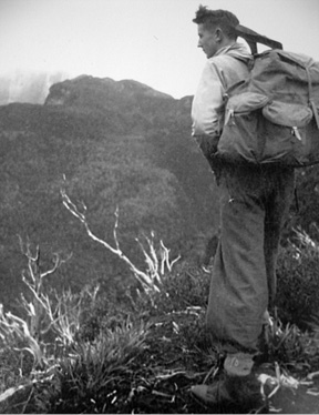
By the 1940s, Frenchmans Cap was beginning to attract walkers from the mainland. Unfamiliar with Tasmanian conditions and changeable weather, many of these parties paid a price for their ill-preparedness. Ida McAuley met a party of three men from Melbourne, including ‘a man in a blue serge suit, a collar and tie, and brown calf shoes, picking his way tentatively and unsteadily, because of the weight and imbalance of his pack’.163 His two companions were similarly attired and ‘one of them carried a shotgun for protection against snakes, of which they seemed unusually apprehensive’. They had been inspired to make the trip after seeing a photograph of Frenchmans Cap in a tourist advertisement.
By the time the trio reached Lake Tahune, minus collars and ties, the weather had turned and the day reserved for climbing the Cap was spent confined to tents under heavy and incessant rain. The next time the party was seen, its members were crouched among big tussocks of button grass on Philps Lead. Ironically, one of the party had been bitten by a tiger snake.
‘The snake, a big one, had bitten just where his boot had broken open and there had been nothing to protect him.’ The bite was cut to encourage bleeding and a ligature was applied, standard snakebite procedure of the day, but a treatment no longer recommended. The patient was then carried to the shelter of the Abels’ log cabin on the south Loddons. It was a lucky escape, as most of the venom appeared to have been absorbed by the victim’s boot. ‘He suffered rather badly from headache and sickness, but was quite fit to travel on the next day.’164
Funding post-World War Two
Like most other Tasmanian tracks, the Frenchmans Cap Track fell into neglect during the years of World War Two (1939–1945).165 Even in times of peace and economic stability, the SPB operated on a shoestring budget, a frequently overlooked appendage of the Lands and Surveys Department.
For example, the government allocated the SPB a miserly annual budget of £278 for 1922, while 1925 amounted to a pitiful £29. With many men and women now away on active service and everything poured into the war effort, the scant funds of the SPB were again stretched to the limit. The task of any track maintenance now depended largely on the efforts of volunteers.
A party of six volunteers from the Hobart Walking Club, led by Jack Thwaites, spent a week before the Christmas of 1944 clearing away fallen logs, slashing overgrowth and repairing log bridges. ‘It was a sort of “reopening”, if you like, of the track to Frenchmans Cap,’ Robert Mather recalled many years later.166 There were also several sections of the Loddon Plains where it was difficult to pick up the track. One section that always seemed to confuse lay beyond Barron Pass, where walkers frequently ventured beyond an old line of stakes and into Livingston Gorge, requiring an exhausting climb up again.
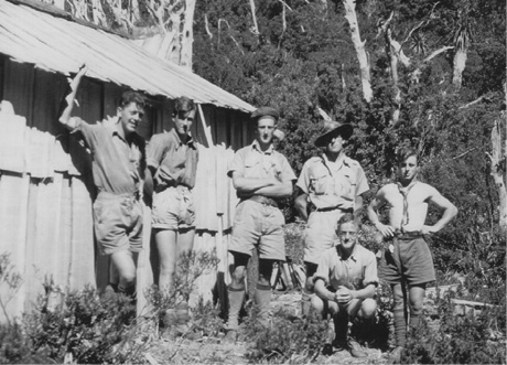
On the Goat Track. Jack McMaster looks across Livingston Gorge, December 1944. (Jack Thwaites)
The ascent route from North Col to the summit of Frenchmans Cap had also become ambiguous and needed to be clearly defined with small cairns or red paint. The party carried in six signposts, which were erected at various stages between the West Coast Road and North Col; ‘and the carriers of said signposts were jolly glad to see them nailed up,’ Jack McMaster admitted in The Tasmanian Tramp.167
Andrew Mather passed his spare moments in camp carving two little yachts for his infant grandsons. He selected a piece of fallen King William pine for the task, and named one of the yachts, appropriately, ‘Tahune’.168 Although the work party did their best under difficult conditions, within two years the track was again in need of clearing. ‘Our party was dogged by almost incessant rain for the first five days,’ Jack Thwaites informed Fred Smithies on their return,‘but it did not affect the cheerfulness of everyone or stop us from getting on with the job.’169
Above Artichoke Valley, 1944. Left—Jack McMaster, Andrew Mather (sitting) Hugh Gordon, Ron Smith and Jack Thwaites (sitting). (Jack Thwaites)
Tahune Hut
Ray Livingston’s plans for a hut had been forgotten, swallowed up in the disruptive maelstrom of World War Two which now affected every level of Australian society. It was Jack Thwaites who stirred the SPB into action, and in due course a letter was sent to Cliff Bradshaw requesting that he ‘erect a small hut, with a fireplace’ at Lake Tahune.
Cliff Bradshaw now ran his own timber mill at Princess River, and wartime labour shortages had left him ‘short-handed on our own game’.170 August 1945 heralded the end of World War Two; servicemen and women returned home and life slowly began to assume some degree of normality.
In early 1946, Cliff Bradshaw and two mill hands walked in to Lake Tahune on a preliminary investigation for the proposed hut. The project was almost abandoned before it began. At first glance, the abundance of King William pine around the lake seemed an ample source of timber. But most of the trees were found to be unsuitable for splitting purposes. ‘We were lucky enough to find the one and only paling tree there, and it will do the job nicely,’ Cliff assured the SPB secretary.
Cliff sent in mill hands Jim Williams and Les Legge, along with his two teenage sons, Bernie and Henry (Curly), to help build the hut. The work party walked in from the West Coast Road, carrying packs and all materials necessary for the job. Bernie Bradshaw recalled: ‘We set off carrying a six-foot cross cut saw, but it tore everyone to pieces, carrying that through the scrub. We put it in the scrub and left it. I think it was somewhere near Lake Vera. We built the hut over a period of a couple of months. The weather governed it, but I think it may have been over three or four trips. We were chased out with the weather a couple of times. It was so windy, it’d blow the milk out of your coffee.’171
A big side of salted bacon was hung up to provide the mainstay of their meals, which were also supplemented with bread, potatoes, cheese and chocolate. They took in a bag of flour for making damper, along with tea and sugar ‘and the occasional apple’.172 Cliff Bradshaw usually had three men working on the hut at any one time.
With the onset of winter, conditions became increasingly difficult. ‘I remember we awoke one morning and saw three inches of snow fall in 10 minutes,’ Bernie recalled. ‘Snowflakes were coming down like dinner plates. You could see them building up. It was getting towards winter and near the end of our stay, and we were out of tucker, so we left whilst we were able.’
Between Lake Tahune and Artichoke Valley, the party walked into a blizzard so strong that at times the best they could manage was to crawl on hands and knees. Frustratingly, when the hut was almost finished, a heavy accumulation of snow over the severe winter of 1946 finally broke the ridge pole. Repairs were not able to be completed until the following summer. The hut was finally ready to receive its first visitors in early January, 1947.
Bernie Bradshaw described the hut: ‘It’d be a welcome shelter to people. It would have slept about half a dozen people, I think, and it was quite a good hut, actually. The palings fitted up pretty well, all things considered, and it was a reasonable size. We put King Billy bark around the corners of the hut and along the ridge cap to stop snow coming in through the gaps, and left an axe so people could cut some firewood.’ The hut was anchored in one corner by a dead King William pine, which was left rooted into the ground to provide additional stability.
Tahune Hut, though a welcome refuge, was not weatherproof. The one paling tree was heavily knotted, and this ‘knotty’ characteristic meant that many of the palings had a ‘ripple’ in them. The lack of suitable palings for the roof meant that it leaked considerably, though this problem was rectified in 1953 when the hut was re-roofed with galvanised iron.
The first visitors arrived only a day after Tahune Hut was completed, passing the hut builders on their way out to the Lyell Highway. Alan Richmond led in a party of six scouts, including a young Eric Sargent, from the Devonport senior scout troop. Eric Sargent would later form Craclair Tours, Tasmania’s first outdoor adventure company. Over the coming decades, Frenchmans Cap would prove a popular destination for scouts from all over Australia and overseas.
In 1995, Senior Ranger Terry Reid arranged to chopper Bernie Bradshaw into Lake Tahune to revisit the site of the old hut he had helped build as a teenager 50 years earlier. Bernie Bradshaw said, ‘We located the stump and it wasn’t that big, probably about 18 inches across. The pieces of the tree that we left were still there, lying on the ground. There were one or two pieces that were too “knotty” to use, so we just left them there.’
First visitors to old Tahune hut, January 1947. Members of Devonport senior scout troop, including Eric Sargent (sitting). (Eric Sargent)