23 At Lake Vera
… suddenly I heard the chainsaw stop and he yelled out, “Hey, look what I’ve found”.
The shingle roof of the original hut at Lake Vera leaked from the very beginning. Fifteen years later, it was clear the hut was no longer capable of providing adequate shelter. Construction of a new hut near the outlet creek from Lake Vera was begun in November 1978 by the National Parks and Wildlife Service (NPWS). The actual building of the hut was carried out by five trainee rangers working under supervision.
The hut’s foundations, framework and trusses were formed of hardwood — Tasmanian oak — and an outer cladding of treated radiata pine. Hardwood joists supported a floor of tongue-and-groove boards, while a roof of colourbond iron sheets completed the new hut, which was ready for occupation after four months. As a bush hut, Vera Hut was maintained to a high standard. Over 20 years, rangers Terry Reid, Bryan Naylor and ‘chippy’ Rudy Veltuis worked hard to considerably improve the comfort of Vera Hut.
Originally known as ‘Michael’s Hut’, many people believe a plaque placed inside the hut commemorated the death of a walker in the Frenchmans Cap region. However, Michael Higgins, a keen Tasmanian bushwalker with deeply-held views on conservation, did not perish anywhere near Frenchmans Cap. Tragically, he took his own life in Launceston in 1976. A bequest to his memory made by his family provided a significant percentage of the overall cost of the new hut. The original, dilapidated old Vera Hut was dismantled 12 months later.
NPWS carries out more work on the Frenchmans track
Between 1976 and 1980, the new NPWS committed itself to a serious trackwork program at Frenchmans Cap. For two months at the end of 1976, Keith Lancaster repaired the track from the Lyell Highway to the Loddon River. Keith, a retired butcher from Launceston, was a respected and accomplished bushwalker who had pioneered routes on a number of Tasmanian mountains. He was the first Tasmanian to climb Federation Peak. Headstrong and determined, he had done so on his own, climbing to the summit and descending in record time — ‘20 minutes up, 19 minutes down’ — in pouring rain. Keith now devoted several years of his ‘retirement’ to contract work for the NPWS. More track work was carried out over 10 days in May 1979, when Keith and track worker Richard Koch cleared the first part of the track from Mount Mullens to the Loddon River.
The Pickaxe Ridge Track
In 1977, an ambitious plan was conceived by the NPWS in Hobart to solve, once and for all, the problem of ‘the Sodden Loddons’. A new high-level track was proposed over Pickaxe Ridge to Lake Vera. Keith Lancaster was a logical choice to survey and cut the new track. In late 1977, he made an ‘exploratory probe’, and in January 1979, began early survey work on the new track. First, he erected a large tent below Pickaxe Ridge to serve as a base camp. He then spent five months surveying and blazing the best line, drawing a detailed map and cutting the first stages of the new track. Most of the time Keith worked with an assistant, usually a NPWS ranger or trainee ranger.222
In 1980, Ranger-in-Charge Dick Dwyer decided to walk the Pickaxe Ridge route. Dick noticed that the route would be subject to severe erosion in a region of high rainfall. He could also see that ongoing maintenance would be required to clear away big trees continually brought down by the storms and gales which frequently lash Pickaxe Ridge.
Ultimately, Dick Dwyer recommended that the project be abandoned. The Pickaxe Ridge plan had absorbed large sums of money on a project that never really rose above more than an ‘investigation’. Once the fate of the Pickaxe Ridge Track had been decided, the NPWS concentrated on upgrading the Frenchmans Track. Dick Dwyer gave the task to Brent McCausland and Richard Koch, who completed some of this work over a two month period in 1980. Richard Koch recalls the nature of the work:
Brent McCausland and I were employed from about March 1980 to do the first ever clearance of the track post-1910. We also had the benefit of a chainsaw so were able to clear many very large logs, especially along the shore of Lake Vera, which Philp had left. I can’t remember now, but I think he [Philp] had cut toe-holds into them. Brent and I also demolished the original Lake Vera hut, built in the early 60s, whose roof had leaked from day one.223
Finding Philp’s camp
Towards the end of May 1980, track workers Brent McCausland and Richard Koch were working on repairing the Philps Lead section of the track. ‘It was on our last stint, and we had decided to fix a very bad section of mud, about 50 m in length, by laying cordwood,’ Richard explained.
Part of the problem, along with the mud, was the tea-tree, which had been pushed over en masse by a very heavy snowfall a couple of years earlier — this snowfall had also stranded two chaps at Tahune. Brent was off cutting rounds in the bush, when suddenly I heard the chainsaw stop and he yelled out, “Hey, look what I’ve found.”224
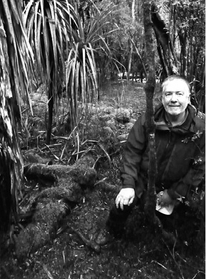
Finding Philps Creek Depot. The author beside the moss-covered remains of a tent platform. (Richard Koch)
Quite by accident, the pair had stumbled upon the Philps Creek depot camp. A square frame of axe-cut spars had been made into a tent platform. It was completely moss-covered, but Richard found that one square-cut nail had survived relatively intact, in the remains of an axe-cut wooden A-frame to support a tent. He removed the nail and took it to the Tasmanian Museum, where it was dated as ‘pre-World War One’.
Ernie Philp was never one to do things by halves. In 1910, to facilitate the task of track-cutting, he established five depot camps between the Franklin River and Lake Vera. The first of these was beside the banks of the Franklin River. Others were located at the foot of Mount Mullens, at the Loddon River and beside the South Loddon River. Philps Creek, at the end of Philps Lead, was the site of the fourth depot. The last depot, and Philp’s personal favourite, was built at the western end of Lake Vera beneath a tall grove of Huon pines.
These semi-permanent camps were used to store rations and equipment. They were also a welcome refuge for the party during frequent periods of bad weather, or after a hard day’s work on the track. First, two log platforms were constructed over which the tents were pitched to keep everyone and everything high and dry. A rough ‘bush kitchen’ was then built using spars to form tables and work areas.
It had been widely believed that all of Philp’s depot camps had disappeared with the passage of time. The 1980 discovery of Philp’s camp remained undisclosed for nearly three decades. Finally, in October 2008, a party of four, guided by Richard Koch, set out to see if Philps Creek Depot still survived.225 In the constantly changing landscape of Frenchmans Cap, heavy rain in May 2007 caused a major landslide. The landslide began about 300 m higher, on the eastern slopes of Philps Peak.
The landslide, awesome in its destructive power, cut a broad swathe down to Philps Lead, uprooting hundreds of trees in its path and even altering the course of a tributary of Philps Creek in one place. The party’s immediate concern was whether the depot camp had been obliterated. But Richard’s welcome ‘coo-ee’ confirmed that he had indeed found the old site, still intact after 98 years. It had narrowly escaped the course of the landslide by about 10 m.
There, in the wet twilight of the forest, the party gazed down on two tent platforms, very much as they appeared to the two track workers twenty-eight years earlier, although the remnants of the A-frame, from which the nail had been taken, had disappeared over time. Tens of thousands of walkers must have passed close by over the years, unaware of the existence of the camp.
Photographs were taken of the site, and the precise location was recorded with GPS readings. Philps Creek Depot has now been officially registered as a historic site. At the end of January 2010, 14 descendants of J. E. Philp, including family members from Norway, America and Fiji, spent several days walking the track to Frenchmans Cap to commemorate the centenary of their ancestor’s historic journey.
Lake Vera bushfire
On 10 December 1980, a bushfire started at Lake Vera. Like the devastating Tahune fire of 1966, conditions at Lake Vera were ideal for wildfire. Frenchmans Cap was sweltering in record December temperatures, an unwelcome spate of hot weather which accompanied the first drought on the west coast since 1934. The region had just recorded its lowest rainfall in 25 years, and the button grass plains were crackle dry.
The fire is believed to have been started accidentally near Vera Hut. Fanned by hot northerly winds, it blazed uncontrolled across a 10 km front. It burnt south across Rumney Plain and crept up the slopes of the Main Range, below Lake Whitham. It was a small consolation that the fire did not spread into adjacent rainforest areas. Stands of forest trees closest to Rumney Plain were ignited, but the forested depths of Philps Forest were spared. The blaze then jumped across to the Loddon Plains and burnt out a great tract of the Jane River country. In the end some 6,000 hectares of wilderness country were needlessly burnt.
Although monitored from the air, no attempt was made to control or extinguish the blaze. The problem lay with the government’s reluctance to spend money and resources on fires that did not pose a direct threat to life or improved property. Wildfires in wilderness areas were mainly left to burn themselves out, or to be eventually doused by rainfall. However, the 1980 Lake Vera bushfire did play a part in the official change of policy on fighting remote area fires. Reviews of government policy in the wake of the 1980-81 fire season meant that huge, devastating conflagrations left to burn in wilderness areas would eventually become a thing of the past. Nevertheless, the 1980 Lake Vera fire, like the 1966 bushfire, was the result of carelessness, and could easily have been avoided.
The Wild Rivers National Park and the World Heritage Area
On 13 April 1981, the Wild Rivers National Park was proclaimed. Ironically, the announcement came at a time when the HEC’s plan to dam the Franklin River was creating widespread waves of dissent. It was the new Wild Rivers National Park, and its inclusion on the World Heritage Register a short time later, that put an abrupt end to the Franklin dam project.
It was the NPWS that first suggested the Wild Rivers National Park. The concept of a park to protect the Gordon and Franklin rivers was unique in Tasmania. Beginning in October 1979, the NPWS, headed by a determined Peter Murrell, pushed strongly for the creation of a Wild Rivers National Park. The NPWS pointed out that the new park would protect several of the state’s most important and dramatic rivers, an entire water catchment area, and embrace a region of spectacular mountain wilderness.
Prime Minister Malcolm Fraser wrote to Premier Doug Lowe in 1980, saying he found it ‘somewhat surprising’ that the Premier had not already submitted a proposal for World Heritage listing.226 Doug Lowe nominated the new park for listing in July 1981, together with the Southwest National Park and the Cradle Mountain–Lake St Clair National Park.
Collectively, the three parks now make up the Tasmanian Wilderness World Heritage Area, a vast area representing about one-fifth of Tasmania. Protecting one of the few remaining true wilderness regions on the planet, the Tasmanian Wilderness World Heritage area, then 760,000 ha in size, was formally inscribed on the World Heritage Register on 14 December 1982. Since then it has been increased to its present size of 1.41 million ha.
Its inclusion on the Register was fully justified. Tasmania’s World Heritage Area (WHA) is home to some of the longest-lived trees and tallest flowering plants left on the earth. Its flora and fauna are unique to Australia and to the world. The WHA represents the last great temperate wilderness left in Australia, and contains its most extensive glaciated landscapes. If any further justification for inclusion was required, it appeared right on cue. On the very eve of the WHA nomination, important archaeological discoveries were made at Kuti Kina Cave on the lower Franklin River.
The cave contained a wealth of evidence of past occupation by Tasmanian Aboriginal people. For Aboriginal leader Michael Mansell, visiting the cave was a spiritual experience. Many other caves, some of the deepest and longest caves in Australia, were also found in the region. It was a huge discovery in terms of the looming battle to save the Franklin.
The global importance of the Tasmanian Wilderness WHA nomination is more than borne out by the facts. The region met all criteria required for natural heritage listing, and three of the six criteria for cultural heritage. At the time of inscription, this represented the greatest number of World Heritage criteria to be satisfied by any listed site on earth. Despite the storm that raged over the Franklin Dam at the time, the Wild Rivers National Park had by then acquired a status that would be enough to ensure its survival.
In 1990, the WHA doubled in size to include the King William Range, Upper Gordon River, Denison Range, Prince of Wales Range, Lower Gordon River, Sorell River, the southern end of Macquarie Harbour, Farm Cove and the Kelly Basin area. The Wild Rivers National Park now enclosed an area of 440,000 hectares. In late 1989, a full PWS Field Centre, under the supervision of a Senior Ranger, was established at Queenstown.