The soils are neutral to alkaline in pH, thus allowing for productive pasture and crop growth. With an alkaline soil pH, which is the result of limestone bedrock, many plant species are able to grow. The limestone is evident on the surface of some paddocks at Stranraer. The building of the homestead and the shearing shed involved digging up limestone in a soft state out of the ground and then the builders would shape the rock with sharp axes while it was still soft to form bricks. Once this limestone is aerated it becomes very hard. This limestone bedrock has implications for agricultural production.
Nutrient status of the soils is important in understanding the limitations to production. Plants have a requirement for key nutrients and for minor nutrients, which are regarded as trace elements. Phosphorus, nitrogen, potassium and sulphur are the key nutrients to assist in plant production. Phosphorus is regarded as deficient in most Australian soil types and is limited in the Stranraer soil. These nutrients need to be monitored through soil testing every 2-3 years. Soil tests involve coring the soil to 10-15 cm depth as this is where plant growth mainly occurs; the soil is sent to a lab for analysis on all the nutrient components including soil texture and pH. This report allows for planning and crop and pasture selection.
The management of soil pH is critical to plant production. The limestone bedrock at Stranraer means that pH is not an issue however, in acidic soils of pH 7 or less lime must be applied to raise the soil pH and enable effective plant growth. Most soil nutrients are more available at a pH of 7 or above.
Sodic soils have been an issue over the years. A soil that is sodic has a high percentage of exchangeable sodium. Sodium has a large impact on soil structure, thus the more sodium that is exchanged in the soil the more the soil will break down and crumble, thus allowing for waterlogging and lack of plant growth. Sodic soils can be managed by the use of gypsum. There were gypsum deposits on the island years ago but these deposits are now exhausted. Gypsum, which is calcium sulphate, when applied to the soil allows the calcium to chemically exchange with the sodium in the soil. The sodium then does not bind to the soil, the calcium does, which prevents soil structural damage, leading to waterlogging and loss of crop and pasture production. Calcium provides stronger bonding for the soil allowing for better water infiltration and nutrient uptake. Gypsum effectively reduces soil dispersion and thus soil structural breakdown.
At Stranraer the limestone bedrock provides a lot of natural calcium which results in good soil structure. The sulphate component of gypsum is utilised by plants which can be deficient. Calcium, as opposed to sodium, provides strength to the soil and also aids in animal health. Soils are managed through consistent soil tests every 3-4 years, to determine nutrient deficiencies.
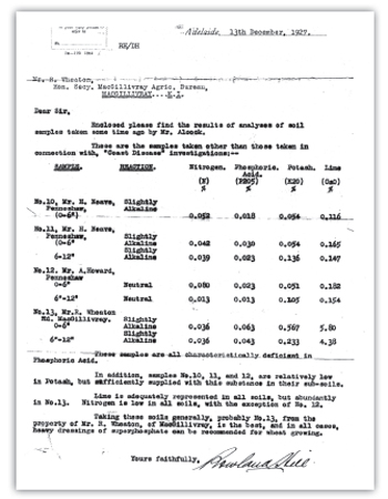
The soil test in 1927 shows the high calcium levels present in the soil at Stranraer due to the limestone bedrock.
Dung beetles are also residents of Stranraer. Australia has about 350 species of native dung beetles and 23 species of dung beetles introduced from Hawaii, Africa and southern Europe. The introduced species are very useful in Australian agriculture especially in cattle dominated areas. They are able to bury large amounts of cattle dung. By having this process there are extensive advantages to the soil including soil structure, better water filtration and soil biology is increased e.g. worms and plants are able to access nutrients more efficiently.
Most of the native dung beetle species eat marsupial dung such as kangaroo, wallaby and possum, which are plentiful at Stranraer however, these species are not efficient at digesting domestic farm animal manure.
The Bubas bison species of dung beetle found at Stranraer is a winter-active dung beetle from southern Europe. This species can be found in Western Australia, South Australia, Victoria, New South Wales and Tasmania. It buries dung beneath the pad in long tunnels that may extend into the soil profile some 50-60cm. Adult females lay eggs within these tunnels. Once the young hatch they remain in the tunnels until they turn into adults and emerge from the soil in the autumn (March to May). Stranraer has no cattle today however, there is still a large number of Bubas bison on the property. The MacGillivray district has a large number of cattle that support this large population of Bubas bison and other introduced species.
The process that the dung beetles perform is of vital importance to soil management. And the removal of the dung material to lower areas in the soil profile removes the risk of erosion through water and wind and the loss of this valuable soil building resource. Bubas bison dung beetles have a life cycle of 1-2 years and for every kg of dung processed and tunnelled into the soil, 1kg of sub soil is bought to the surface.
Drenches used for the control of stomach worms in both sheep and cattle, which have a chemical base, need to be monitored as these can have a devastating impact on dung beetle populations.
The naturally infertile soils of Kangaroo Island had responded to adequate dressings of phosphatic fertilisers and trace elements, but in time it was becoming apparent that the former was causing a soil acidity problem. This was documented in the council minutes in 1986. The suggested remedy at this point was the application of lime in some form. Since there was a large deposit of suitable wind-blown lime sand known locally as the Little Sahara near the south coast, pressure for its use as a soil corrective began. The council requested an environmental impact study to be completed to determine the merits of mining this resource. Locals were asked to write letters stating their views. Thirty two letters were received and presented to council on 11th February, 1987. Consent was given only for a certain area to be mined.
The management of soil has changed over the years with the cropping program in particular. In the clydesdale and early tractor years most paddocks were ploughed to manage weeds and also prepare the soil for seeding. Today, with the use of seeding technology and no tillage farming in particular, soil disturbance is very minimal, thus weed control has become reliant on the use of chemicals. Stranraer today is livestock focused more than cropping, so soil management is strongly related to the stocking rate to reduce soil erosion and to ensure soil is protected by using perennial grasses such as fescue and phalaris, and legume based perennials such as lucerne.
Soil acidity has a severe impact on the earth and its production capabilities. The soil alkalinity or acidity is measured on a scale like the pH scale. pH is a measure of the concentration of hydrogen ions in the soil. The higher the concentration of hydrogen ions, the more acidic the soil. This process is a result of chemical reactions in the soil, so if a soil is pH 7 then this soil is regarded as neutral. If a soil has a pH less than 7 then the soil is acidic, if greater than 7 then the soil is alkaline. This reading is of great significance to agricultural production. If we consider the plants that we use in Australian agriculture, most are suited to a neutral or alkaline soil. Wheat, which is one of the main cereal crops grown in Australia, is best grown in soil which is neutral or slightly alkaline.
In the country that my family have farmed for some time the pH ranges from 6.5-9.0, this allows for a wide range of plants to be grown for both grain and livestock production. This soil pH as well as soil nutrient status is monitored through continuous soil testing which involves taking a 10-15cm soil core and sending it to a soil lab for analysis. Plant testing of crops and pastures also allows for the nutrients to be monitored that are available to the plant. Some soils with high pH have the ability to reduce the availability of nutrients to the plant, primarily to do with the calcium. This also occurs in low pH or acidic soils where aluminium becomes soluble and readily available to plants. Aluminium is toxic to a high percentage of plants and this highlights the importance of understanding soil pH.
There are processes of farming activity that impact on soil pH. Nitrogen and phosphorous based fertilisers are acidic in nature and are used to assist crop and pasture production. Therefore, continuous cropping properties have the potential to increase soil acidity over time thus reducing yields and quality of grain grown. Grazing systems also have the ability to increase acidity with fertilisers and the constant pressure from grazing animals over time will increase soil acidity if not managed correctly. In grazing systems in southern Australia, legume plants are used as they are high in protein and energy, this allows for rapid animal growth. These plants fix nitrogen from the atmosphere. By this I mean that the plant has the ability to draw in nitrogen from the air and be able to convert it to usable nitrogen by the plant. With this process the excess nitrogen is released into the soil. This nitrogen also has the ability to increase soil acidity.
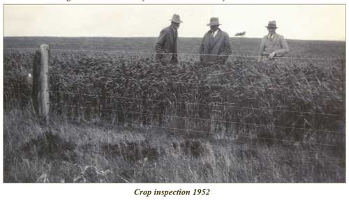
Understanding crops and their management was as vital in the 1950s as it is today.
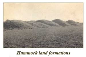
Paddock names on Stranraer relate to some event, person or feature that the area represents. Nelson for example is a paddock named after a workman called Nelson who cleared the whole area with an axe.. The hummocks were named to describe the lunette system of ‘small hills’ that line the eastern edge of Rush Lagoon. The Redhill was named after the terra rossa soil that is present there. Quail paddock, reflects the low lying areas that are suited to quails nesting in the region. Wattle Grove continues as this was the name of the school that existed years ago.
The Still paddock in years gone by used to operate a still for the manufacture of eucalyptus oil.
All of these paddocks have different soil types and thus are farmed and managed differently. The areas along the hummocks reflect a heavier clay soil type that is suited to cropping and lucerne production due to the high pH of the soil. Areas around Rush Lagoon are suited to grazing as these areas become quite wet during the winter and Wattle Grove is a relatively sandy soil type, best suited to grazing and lucerne production.
All areas have their allocated areas represented as hectares, which assists with stocking rate decisions and seed required if cropped. Crop yields and hay production can also be measured by knowing the hectares. By allocating the proper paddocks to their production potential and soil limitations the whole farm plan can be put together.
The areas of the farm with sandy soil types need to be managed differently to a soil type with a clay base for erosion reasons.
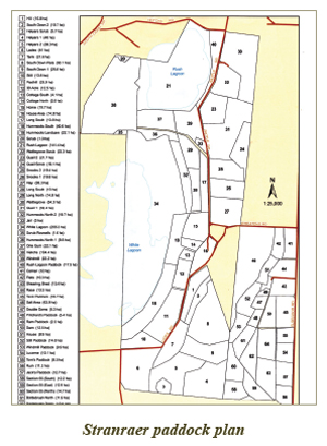
The property is divided into paddocks represented in the map above. This allows for easier stock and pasture management and segregation of breeds and ages of livestock.

Since the mid 90s Stranraer has undergone an extensive program to revitalise and protect the natural resource base of the property. Over 495 hectares of the property has been protected, this includes Rush & White Lagoons, Wattle Grove, Quail Paddock and Helyars.

Conservation at Stranraer has involved over 20km’s of fencing, 23 hectares of re-vegetation and the planting of 250 hectares of perennial pasture to support the livestock system.
Stranraer is a member of the Trees for Life program, which is a volunteer program of growing seedling trees that are native to particular regions around South Australia. Over this time period, since 1995, 1000 trees have been planted annually. The process involved uses a ripper through the soil and planting the trees in the prepared soil.
The main species grown are sugar gum, cup or swamp gum, KI narrow leaf mallee, southern blue gum, pink gum and a variety of melaleucas.
Narrow leaf or Kangaroo Island mallee (Eucalyptus cneorifolia) grows in the 400-650mm rainfall area which represents a majority of Kangaroo Island. This species is ideal for wind protection and shelter for livestock. The timber is used in the Stranraer fireplaces and in the early days was used for eucalyptus oil production. These trees can reach 12 metres in height and have thick walled leaves and a small white flower.
I remember planting 500 trees below the workmen’s cottage in 1995, ripping the area into approximately 20 rows. In sitting down to lunch that day, dad informed me that the phone was disconnected or not working. With a little investigation I realised that I had severed the underground phone line 20 times.

These plantings have been carried out to assist stock shelter through wind breaks and grown in areas that are unproductive for agriculture and for attracting birds around the homestead. Seeds are collected through the program and propagated by volunteers then moved to landholders as seedlings for planting.

The grey and white areas on the previous aerial photograph show areas of scald and surface salinity. Scald being where vegetation does not grow due to poor soil structure and the presence of soluble salts in the upper areas of the soil profile.
The Wattle Grove vegetation area located in the northern region of the property has numerous bottlebrush species, which in October and November have extensive flowering. Apiarists in the region place bee boxes in this area to produce honey from the working bees. Within this area of 22.3 ha is a small lagoon called Lee Lagoon. This is a lagoon of medium water quality and attracts various bird species and is home to a kangaroo population.
Salt water, which weighs more than fresh water, sits below the fresh water layer in the aquifer where it then gravitates to the sea. Farming in some situations has resulted in the movement of this saline water and having it exposed at the surface, similar to what happened with Rush Lagoon.
Salinity, which by definition is ‘salts in solution,’ affects over 2 million hectares in Australia. Of this, 800,000 hectares is unable to be used for agricultural production.
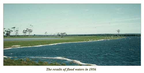
Salt has been accumulating in the landscape for centuries. Salt arrives in the soil through rainfall. Salt water, due to its weight, filters through the soil profile and accumulates at depth. A freshwater layer sits above this salt layer preventing it from impacting on plant growth. Agricultural practices over time have disturbed this system resulting in the movement of this salt through the soil profile and exposure at the surface where no vegetation will grow. I have seen this personally at our property Stranraer. Soil affected by salinity is very difficult to return to a productive state. The area below on ‘Stranraer’ was impacted in 1956 by flooding. The management of this area has changed considerably over the years.
The management of these saline areas in Australia has taken many forms including the use of crops, pastures and fodder plants with salt tolerance, tree plantations, earth works and fencing. The main cause of salinity, as seen on Stranraer over the years, has been the removal of plants. Plants utilise water in the A horizon of the soil; without these plants water moves through the soil profile at speed, causing the salt to move laterally in the soil. Salt water sits below the freshwater layer in the aquifer system. In the drilling of new bores, as was done in 2006, it is important to manage the depth of the bore drill to ensure that the quality water is not contaminated by the salt water that sits below it.

Stranraer has seen this occur in a number of areas on the property and the remedy in most of the cases has been to destock the areas and allow salt tolerant grasses to grow. Grasses and other plants have the ability to reduce and minimize the impact of salinity, by utilising water from rainfall and preventing it from moving through the soil profile thereby displacing salt and moving it laterally.
The grasses used in the regeneration of these areas are Puccinellia (Puccinellia ciliata), Tall Wheat Grass (Thinopyrum ponticum)and the planting of melaleuca trees. Puccinellia grows in alkaline soil (but not acidic) and saline soils. Puccinellia is a perennial grass that forms tussocks up to 40cm high and wide. The plants hay-off in the December and remain dormant over summer. The nutritive value of puccinellia varies over the season; early in the season the plant is 60-70% digestible. As the plants flower, digestibility reduces to 10%.
Tall wheat grass is widely grown in summer-moist areas and on soils of low to moderate salinity. Soil salinity is measured through a soil analysis. Tall wheat grass is summer active with most growth occurring from late spring onwards. The quality of tall wheat grass declines in late summer, so it is important to graze the plant before the stems are fully mature. Heavy grazing encourages tillering and maintains the quality of feed. Often, both tall wheat grass and puccinellia can be planted together to provide stability to waterlogged and saline soils.
Legumes also have the ability to regenerate areas of waterlogging however, most species have a low tolerance to salinity. Balansa clover is able to tolerate waterlogging, but is not highly tolerant of saline soils. Legumes provide highly digestible feed with high protein for livestock growth.
The Australian salinity issue is already very significant and having a tremendous impact on agricultural production. The National Land and Water Resources Audit estimates that 5.7 million hectares have a high potential for the development of dryland salinity, and predicts this will rise to 17 million hectares by 2050.
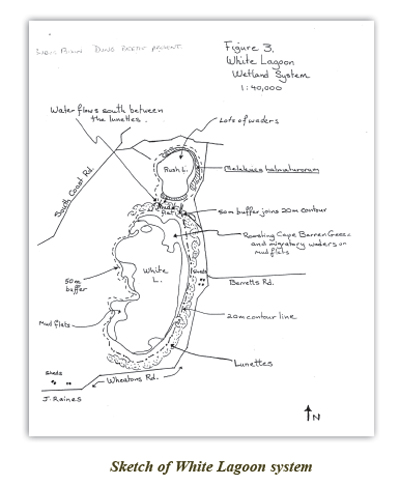
The White Lagoon Wetland System (750 ha) comprises Rush Lagoon to the north, White Lagoon to the south and the mud flat which lies in between. The system is 22km south of Kingscote and boundary nominations are defined by a 25 metre depression contour (hummocks) on the east and south sides.
The water quality on Rush Lagoon is of a better quality than White Lagoon. White Lagoon has a saline level that is higher than sea water, which is around 36,000 ppm salt, while Rush Lagoon is 10,000 ppm.
The topography for White Lagoon suggests that water movement over the whole MacGillivray district results in an accumulation of salt water in White Lagoon. It is from here that this heavy saline water moves through the lower part of the aquifer to the sea in a southerly direction. This is a natural process that has been occurring for many years.
The White Lagoon Wetland System is a valuable wetland habitat especially for waterbirds. It is an important feeding, resting and breeding refuge for many species of waterbird, particularly in summer. A large variety of fauna and flora including 45 waterbirds use the wetland system. This is a significant number of waterbirds compared to numbers recorded on wetlands elsewhere. It has an abundance of invertebrate fauna, including salt lake louse (Haleniscus Scarlei) and the mollusc (Coxiella striata) which provides an important source of food for waterbirds. The system also provides a suitable habitat for waterbird species to breed, (20) of which two are threatened species. As waterbird breeding colonies are not well documented or protected in Australia, the presence of the Sacred Ibis (Threskiornis aethiopica) breeding colony at Rush Lagoon is significant. Kangaroo Island has recorded 267 bird species along with 890 species of native plants.
Of the many species of waterbirds found in the White Lagoon Wetland System five are scheduled in the South Australian National Parks and Wildlife Act (1972) as amended in 1988. The Cape Barren Goose (Cereopsis novaehollandiae), Musk Duck (Biziura lobata), Latham’s Snipe (Gallinago hardwickii) and Hooded Plover (Charadrius cucullatus) are considered vulnerable, whilst the Australian Shoveler (Anas rhynchotis) is considered rare. The Hooded Plover and the Freckled Duck (Stictonetta naevosa) are also considered rare at an international level.
The Bush Thick-Knee (Burhinus grallarius) (non waterbird) is endangered and also lives in the system and the only mistletoe on Kangaroo Island (Amyema melaleuca) occurs at this site.
In addition, the lunette formation at White Lagoon is the largest and the best illustrative remnant on Kangaroo Island, of a recent geomorphic process involving the contraction and migration of ancestral lagoon systems.
The White Lagoon System is located in a depression on a relatively flat, poorly drained plain, which lies east of the Timber Creek catchment and south-west of the Bugga Bugga Creek. Rush Lagoon is a shallow, seasonally intermittent fresh water lake. It receives inflow from an unnamed creek originating 3-4 km to the north. White Lagoon is a shallow, permanent, brackish-saline lake surrounded by large areas of mudflats. It receives inflow from an un-named creek originating up to 9 km to the north and from Rush Lagoon via the mud flats. The system also has a high local watertable associated with it.
Both lagoons contain the aquatic plants Widgeon Grass (Ruppia Spiralis) and Mush Grass (Chara). Rush Lagoon supports Myriophyllum and Crassula and White Lagoon contains Dunaliella Salina – a single cell alga which gives salt lakes their pink colouration. White Lagoon has a marginal band of scrubland comprising Swamp Paperbark (Eucalyptus cneorifolia) and Acacia with an understory of Samolus Repens.
A striking feature of White Lagoon is the lunette formation. The lunettes are composed of calcareous, silty clay and are particularly steep. Lines of them form an arc around the eastern margin of White Lagoon and curve around the southern and northern ends.
There are many lunette formations on Kangaroo Island including the hummocks at Stranraer in the Hundred of MacGillivray, where lunettes fringe the eastern shore of White lagoon. These lunettes are 23 metres in height and usually occur on the eastern shores of lakes, lagoons and depressions, which intermittently contain water. The composition of these lunettes ranges from silt to clay. These sediments are usually structureless and poorly consolidated. The soils at times represent soil that is high in sodium with very little structure and poor drainage. Most of these lunette formations are grassed and rarely will trees be found on them. The lunettes at Stranraer do not have any trees on them, however between them and White Lagoon there are trees populations. Most lunette formations in Australia are encountered in the semi-arid regions of the southern states. Most lunettes appear to be fossil features rather than forming today.
The outermost generation of lunettes is very hummocky, so much so that the area has always been referred to as ‘The Hummocks.’ The leeward side of the lunettes appear to be steeper than the western facing slope.
Various theories have been presented as to how the hummocks were formed. One involves the trapping of westerly borne dust, particularly on the eastern shores of the lakes, by moist air above the lake.
A second theory involves the deflation of material from the dry lake floor by westerly winds and the deposition of this material on the eastern side of the lake, where it is trapped by vegetation. Thus any material capable of being transported by the wind can be incorporated into the lunette. Waves generated by winter westerlies have been important in accumulating material on the eastern shoreline and in fact, steepening the side of the lunette fronting White Lagoon.
The third theory is that these are remnants of a much larger ancestral lagoon, which was originally a water filled depression left on a coastal plain as the sea level retreated. The development of distinct and separate lunette lines around the lagoon, is evidence that the ancestral lagoon both contracted in size and migrated westward.
Between the outer hummocks area and the farm building of Stranraer, the terrain is occupied by a former lake floor and an older, much modified sequence of lunette ridges now mantled by resistant calcareous material known as calcrete. A grey black soil developed on the calcrete. This soil is soil that supports most of the Stranraer cropping and lucerne production, ideal for cropping with an alkaline soil pH. Farm buildings at Stranraer have been constructed out of stones that are a product of this soil/regolith process and have led to the dissolution and recementation of materials that were originally soft calcareous marls to form tough resistant building materials over perhaps many tens of thousands of years.
The White Lagoon Wetland System supports eight species of waterbirds listed on the international migratory bird treaties. Seven are listed on the Japan-Australia Migratory Bird Agreement (JAMBA) and seven are listed on the China-Australia Migratory Bird Agreement (CAMBA). These treaties, signed by the Australian government, oblige us to conserve the birds listed to enhance their survival worldwide.
The northern area of the Rush Lagoon wetland, which is not part of Stranraer is home to a sand quarry. This is very high quality sand that was used to lay the foundations for the Kingscote District Hospital that was completed in 1930 at the time of the great depression. In 1953, the Kingscote Council purchased the sand pit as it would then be used in the construction of buildings in Kingscote as it developed. In 1955 the town hall redevelopment was completed using sand from the MacGillivray quarry.
The southern area of the White Lagoon system is also home to a very high quality sand.. The clay lunettes in the above picture represent the hummocks and also the transition of salt water via the ground water system to D’Estrees Bay. These lunettes lie WNW-ESE. The most effective dune-forming modern winds during the dry (summer) season are likely to have been effective in lunette building (Campbell 1968). Therefore, the wind pattern between 7000 and 4000 years ago seems to be the same as the present, indicating no major shift during the past 7000 years. Wind velocities during this period must have been moderately high, to not only build the lunette, but also to raise waves producing the longshore drift necessary to maintain a supply of sand at the northern end of the lake 4000-7000 years ago the White Lagoon System operated as one system but today the system exists as two bodies of water, White Lagoon and Rush Lagoon. The site today exists of dune fields and shallow depressions relating to this and other former lakes. It is flattish and low lying, covered with mallee shrub land in which Eucalyptus cneorifolia or Kangaroo Island Mallee is the dominant vegetation. The sand quarry at the northern end of Rush Lagoon was extensively developed to assist the building development on Kangaroo Island. Most of the building construction in Kingscote was completed with the use of the MacGillivray quarry sand.
Rush Lagoon - named due to the number of rushes present in the early days.
White Lagoon - named due to the salt layer ‘white crust’ on the surface
Rush Lagoon was able to support cropping prior to 1956, now with the movement of the 1956 water mass, salt was exposed at the surface resulting in the soil becoming salty and unfit for agricultural purposes. The fencing of Rush Lagoon has resulted in the regeneration of the 1000s of melaleuca halmaturorum, also known as swamp paperbark. This also assisted with salinity management and protection for the migratory birds that flock to Rush Lagoon on an annual basis, whilst also protecting the water supply.
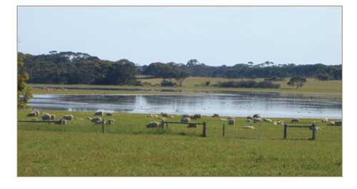
Rush Lagoon is 141.4 ha (350 acres) in size. During wet years the whole area becomes covered with water and migratory birds begin to move to the area in October in any given year.
Since 1984 the management of Rush Lagoon has been a very important part of the property. An extensive fencing program was put into place with the assistance of the Kangaroo Island Natural Resources group. The aim of the fencing program was to remove stock access to the area to encourage the natural regeneration of melaleuca halmaturorum.
This process of regeneration for Rush Lagoon has been a work in progress. If we look at the site now in 2012, the regeneration of the area is quite evident. The preservation of the natural resource base to encourage and protect the migratory bird population along with kangaroos and wallabies has been quite evident.
Salinity management has also been assisted with the regeneration of the area.
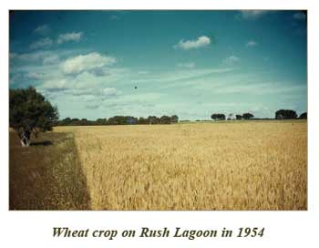
Wheat growing on the southern edge of Rush Lagoon in the early 1950s. However, with the flood water in 1956, White Lagoon water joined Rush Lagoon and the result was saline water entering the region which halted the growth of grass and other plant species.
The preservation of the Rush Lagoon environment has assisted in maintaining the water quality for the property.
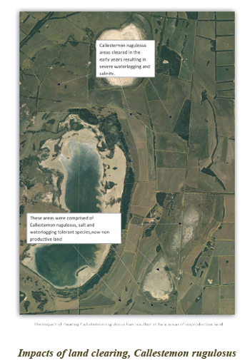
An area at the northern end of the property was cleared of its bottlebrush in the 1960s to increase the grazing area for livestock. This area has never recovered and water lies there most of the year with no pasture growth for livestock. This area is a visual reminder of the impact of clearing especially in low lying areas and the value of vegetation. The area was cleared with crawlers and chains over a period of time.


The photo above shows the regeneration of the Melaleuca halmaturorum population on the eastern edge of Rush Lagoon after it was fenced off from livestock and is a haven for migratory birds from August until February.
This Malaleuca halmaturorum regeneration has occurred since 2010 on Rush Lagoon due to the extensive fencing plan to protect the area. This species is found in areas of Western Australia, South Australia’s Eyre Peninsula and south east of South Australia along the Coorong. This species can grow to 8 metres in height. It often forms thickets in swampy areas subject to waterlogging, including the fringes of salt lakes and coastal sand dunes. Some areas of Rush Lagoon are difficult to walk through due to the density of the melaleuca halmaturorum. Mature seed capsules are maintained on plants for several seasons. With the fencing off of Rush Lagoon the germination will increase rapidly due to the longevity and viability of the seed.
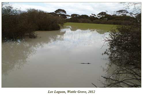
Lee Lagoon is part of the Wattle Grove area, comprising 22.3 ha. This area was preserved in 1998 to reduce the impact of grazing livestock and to protect the area, which has numerous bottlebrush species that flower in October-November.