
Plan your walk |
|
 |
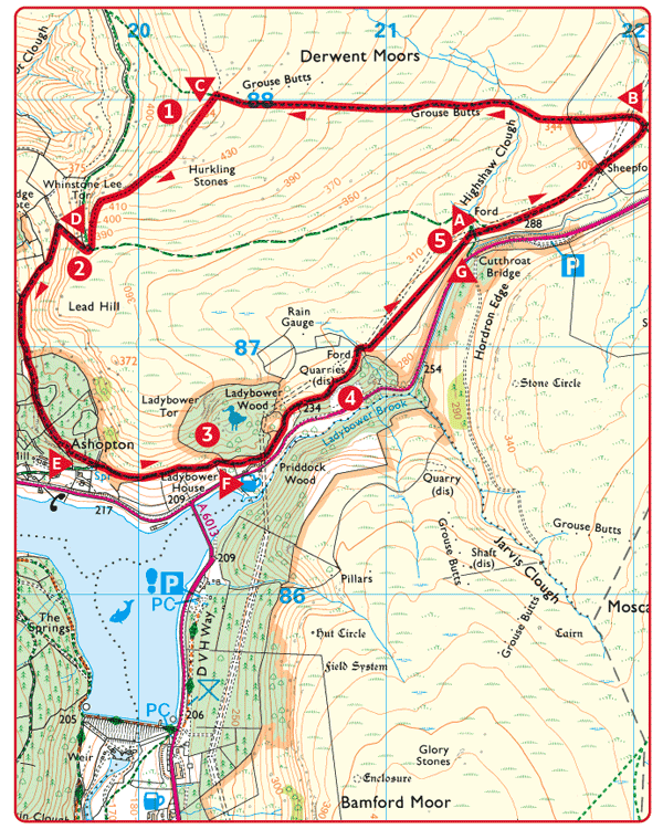
DISTANCE: 4¾ miles (7.6km) TIME: 2½ hours START/END: SK214874 Car park at Cutthroat Bridge TERRAIN: Strenuous; MAPS: |
 Park in the large layby and walk down the road, for 150yds (140m), cross over and then turn right on the rocky path. Turn sharp right beneath power lines. Cross the stream and follow a grassy path across the moor.
 At the gateway overlooking the stream and farm, turn sharp left and follow the stone wall. Beyond the upper wall, the path crosses the moor, following a line of shooting butts for 1½ miles (2.4km).
 Turn left along the crest of the rocky moorland escarpment.
 Viewpoint. ‘Wheel Stones’ or the ‘Coach & Horses’, are the first of a line of distinctive gritstone outcrops along Derwent Edge. It is possible to extend the walk to make a closer inspection of the outcrops.
 Turn right and go down the hillside for ½ mile (800m). Follow the tracks to the left of the boundary wall, through mature pine forest.
 Viewpoint looking across the northern arm of Ladybower Reservoir. The building of the reservoir between 1935 and 1943 resulted in the drowning of the villages of Ashopton and Derwent and created what was, at the time, the largest reservoir in Britain. During exceptionally dry summers the foundations of Derwent village can still be seen. The last time this happened was in 2004 when some remains of the church gateposts and a bridge over the River Derwent were still clearly visible. Ashopton was located to the south of the A57 viaduct and was more extensively demolished in 1943 before the reservoir was flooded. What little remained was covered in silt many years ago.

 Leave the forest and bear left for ½ mile (800m), above a group of farm buildings, and go through two gates.
 Turn right for the Ladybower Inn, otherwise bear left at the footpath junction (return to this point if visiting the pub). Climb the rocky path to the open moor. 1¼ miles (2km).
 Ladybower Woods is a nature reserve owned and cared for by the Derbyshire Wildlife Trust. It is one of the few upland oakwoods left in the Peak District.
 Viewpoint. Look back at the surprise view of the lower section of Ladybower Reservoir.
 Turn right at the footpath junction to rejoin the A57.
 Cutthroat Bridge. The name commemorates the spot where a man was found barely alive with a wound to his throat in 1635. He died in Bamford Hall two days later. The bridge wasn’t built until 1821 but the gruesome event is remembered in its name.