Plan your walk |
|
 |
DISTANCE: 5 miles (8km) TIME: 3 hours START/END: SK109551 Wetton TERRAIN: Moderate / Strenuous; one climb of 295ft (90m) MAPS: |
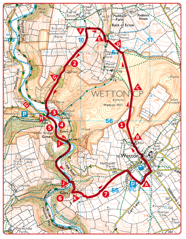
 Park in Wetton and follow the village street past the church. Where the road turns left, follow the direction of the signpost to ‘Back of Ecton’. 400yds (370m).
 Go through the gate and stone squeezer stile on either side of the small, disused quarry. Follow a faint field path as far as the field boundary below Wetton Hill. ½ mile (800m).
 Viewpoint. Butterton church spire rises above the Manifold Valley.
 Bear right, away from the wall. ½ mile (800m).
 Go over the stile in the corner of the field and climb the next to its top boundary. Climb the stile, turn right and follow the path to the road. Follow the road left up the hill for about 75yds (70m).
 Turn right, along an access drive and left at its junction with another track. 200yds (180m).
 Where the farm track turns right, go left following the boundary wall downhill. Move over to the right and then back left through the opening in the fence. Turn right through a stone squeezer stile, then follow the path down into the dry valley. 1 mile (1.6km).
 The prominent knoll to the left of the path is aptly called the Sugarloaf.

 Continue down the dry valley through the stockyard at Dale Farm and into the Manifold Valley. ½ mile (800m).
 Wettonmill. Once ground flour for the surrounding villages.
 Turn left along the valley road, then right and left over the river. ¼ mile (400m).
 The valley section of this walk follows part of the route of the Manifold Valley Light Railway, a narrow gauge line which ran between Hulme End and Waterhouses from 1904 to 1934.
 Dafar Bridge. In dry weather, the River Manifold disappears underground at this point, reappearing near Ilam Hall.
 Go through a gate, away from the road, along the old railway track. ½ mile (800m).
 Turn left over a footbridge and follow the stepped path uphill. After about 330yds (300m) turn right and follow steps to Thor’s Cave.
 Thor’s Cave makes a perfect frame for a breathtaking view of the Manifold Valley.
 From the front of the cave, follow the concessionary path and walled lane to Wetton. ¾ mile (1.2km).
 Viewpoint. The slender spire of Grindon church stands out across the Manifold.
