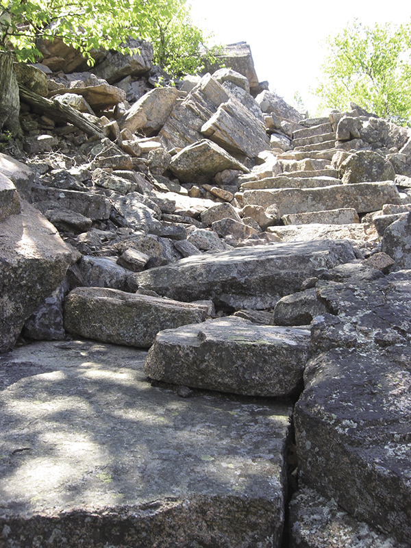
The climb is made more civilized by neatly laid granite steps.
3 Beachcroft Path
Intricately laid stone steps lead much of the way to open views along Huguenot Head, on the shoulder of Champlain Mountain. In line with its more than century-old history, this route’s name is reverting to the original description as a path, rather than a trail, to better characterize its highly constructed nature. It’s a mostly moderate ascent to Huguenot Head; more strenuous to reach Champlain and its ocean views.
Distance: 2.4 miles out and back
Hiking time: About 2 to 3 hours
Trail surface: Granite steps, rock ledges, forest floor
Best season: Spring through fall
Other trail users: None
Canine compatibility: Leashed dogs permitted but not recommended on upper Beachcroft
Map: USGS Acadia National Park and Vicinity
Special considerations: There are no facilities at the trailhead. Seasonal restrooms are available at the nearby Sieur de Monts park entrance.
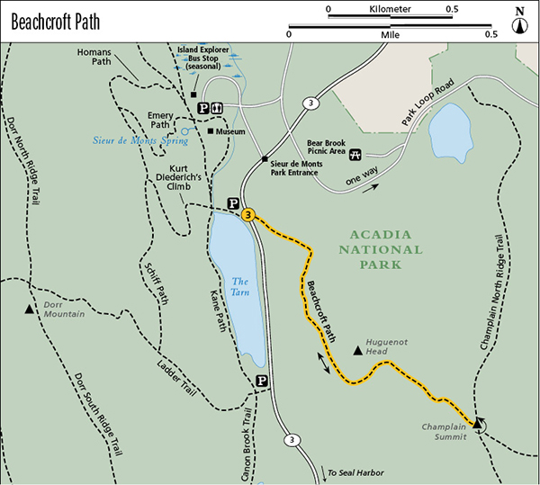
Finding the trailhead: From downtown Bar Harbor head south on ME 3 for about 2.2 miles, just past the park’s Sieur de Monts entrance, to the parking lot on the right (west) just before the glacially carved lake known as the Tarn. The trailhead is on the left (east) side of ME 3, across the road diagonally (southeast) from the parking lot. The closest Island Explorer stop is Sieur de Monts on the Sand Beach and Loop Road lines. GPS: N44 35.84' / W68 20.53'
The Hike
The Beachcroft Path climbs first to the shoulder of Huguenot Head, with an average elevation gain of 100 feet each 0.1 mile, but at times it feels remarkably like a walk along a garden path. The gradual switchbacks and neatly laid stepping stones turn what would otherwise be a vertical scramble into a gentler ascent.
Adding to the wonder are the constant open views north toward Frenchman Bay, west toward Dorr Mountain, south toward the Cranberry Isles, east toward Champlain Mountain, and down to the Tarn.
The climb is made more civilized by neatly laid granite steps.
The dome-shaped Huguenot Head, visible from Bar Harbor, has been a popular destination for more than a century. The Beachcroft Path, built and rebuilt in the late 1800s and early 1900s, was named for the estate of the Bar Harbor summer resident who financed its construction. It consists of hundreds of hand-hewn stepping stones and countless switchbacks.
From the trailhead across from the Tarn parking area, ascend via the switchbacks and stone steps, catching your breath on the plentiful level sections.
Near the shoulder of Huguenot Head, the path widens and levels off. It circles to the northeast as you reach the open ledge just below the head’s summit at 0.7 mile, with views south toward the Cranberry Isles. To the east (left) is Champlain Mountain; to the west (right) is Dorr Mountain. Down below are the Tarn and ME 3.
The trail then dips into a gully before it begins the strenuous ascent up the sheer west face of Champlain Mountain. Carefully pick your steps and follow the cairns up the rock slabs. You reach the open summit at 1.2 miles.
Return the way you came.
Miles and Directions
0.0Start at the Beachcroft Path trailhead, diagonally (southeast) across ME 3 from the parking lot that’s just south of the Sieur de Monts park entrance.
0.7Reach the open ledge on the shoulder of Huguenot Head and enjoy the views.
1.2Summit Champlain, and reach the junction with the Champlain North and South Ridge Trails and the Precipice Trail. Retrace your steps.
2.4Arrive back at the trailhead.