
The enduring pickerelweed brightens up the Tarn.
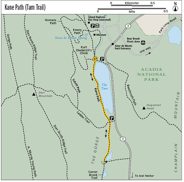
17 Kane Path (Tarn Trail)
Huge stepping-stones placed just so along the Tarn, a mountain pond at the base of Dorr Mountain, turn what would otherwise be a tough clamber into practically a garden stroll. Along the way you get views of Huguenot Head on the shoulder of Champlain Mountain, across the glacier-carved valley. If you’re lucky you might catch glimpses of otters, bats, and other wildlife that find a home at the Tarn.
Distance: 1.8 miles out and back
Hiking time: About 2 to 2.5 hours
Trail surface: Granite steps, wooden bridges, forest floor, rock ledges
Best season: Spring through fall
Other trail users: Hikers climbing Dorr Mountain
Canine compatibility: Leashed dogs permitted
Map: USGS Acadia National Park and Vicinity
Special considerations: No facilities at the trailhead; seasonal restrooms at the Sieur de Monts parking area, 0.3 mile north on the Jesup or Wild Gardens Path
Finding the trailhead: Drive south from downtown Bar Harbor on ME 3 a little more than 2 miles, just past the Sieur de Monts park entrance, to the Tarn parking lot on the right (west). Follow a dirt path at the south end of the parking area. Turn right at the end of a split-rail fence, following another dirt path to a junction. Cross over the outlet of the Tarn on a series of well-placed level rocks. Do not follow the signs that point right to Sieur de Monts Spring. Reach the trailhead in 0.1 mile at a four-way intersection. Go left (south) along the western shore of the Tarn. The Island Explorer’s Sand Beach and Loop Road lines stop at Sieur de Monts, requiring a 0.3-mile hike to the trailhead on either the Wild Gardens Path or the southern spur of Jesup Path. GPS: N44 35.81' / W68 20.72'
The Hike
Rather than just driving by the Tarn on ME 3, take this path to get a better appreciation of the mountain pond in the gorge between Dorr and Champlain Mountains and of Acadia’s ever-changing, ever-surprising nature. We’ve seen artists painting along the pond and have heard that photographers come here at sunrise to capture the Tarn’s reflection-pool effect. Our nieces, Sharon and Michelle, who joined us on a hike here one unusually hot July, even found tiny fish swimming in a brook that empties into the Tarn. Fish like pumpkinseed sunfish and ninespine stickleback are native to the pond. Otters, herons, bats, and a variety of pond plants also find a home here. One time, while we were descending Kurt Diederich’s Climb to the pond near dusk, we saw bats flitting around.
The enduring pickerelweed brightens up the Tarn.
Kane Path begins on the north end of the pond, across the outlet, at an intersection with Jesup Path coming in on the right and Kurt Diederich’s Climb coming down from Dorr. At the northwest corner of the intersection, there’s a 1913 plaque set in a boulder inscribed: “In Memory of John Innes Kane, a man of kindness who found his happiness in giving others pleasure.”
Turn left (south) at the intersection to follow Kane Path along the west shore of the pond. Huguenot Head to the left (east) and Dorr Mountain to the right (west) soon come into view. You may also hear the traffic whizzing by on ME 3 across the pond.
Much of this part of the trail is on the flat surfaces of huge granite slabs along the base of a Dorr Mountain rockslide. Some of the granite is pink, mirroring the pink of the rockslide on Huguenot Head across the gorge. Although the trail is fairly level, there is some rock hopping involved. The best views are along the Tarn, so don’t make the mistake of failing to notice them along the way.
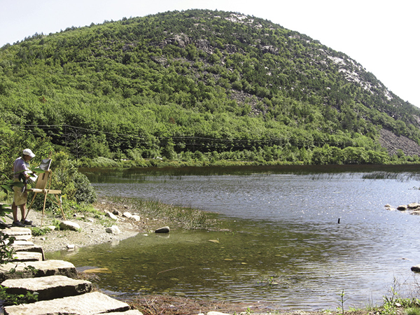
An artist sets up his easel by the stepping stones that lead to Kane Path across the mouth of the Tarn.
After passing the south end of the Tarn at 0.5 mile, the trail reaches a junction with the Ladder Trail, which heads steeply right (west) up Dorr Mountain. This is where our nieces rested in the shade one hot July afternoon and spotted tiny fish in the brook.
Continue straight (south) on what has now become an easy wood path, reaching trail’s end at 0.9 mile at a junction with the Canon Brook Trail.
Return the way you came.
Miles and Directions
0.0Start at the Kane Path trailhead, 0.1 mile from the Tarn parking lot, across the outlet of the Tarn. Turn left (south) along the western shore of the mountain pond.
0.5Reach a junction with the Ladder Trail. Continue straight (south) on Kane Path.
0.9Trail ends at the junction with the Canon Brook Trail. Retrace your steps.
1.8Arrive back at the trailhead.