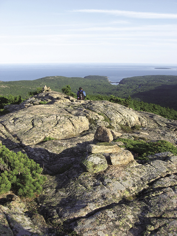
The Dorr South Ridge Trail brings ever-closer views of Otter Cove and the Cranberry Isles.
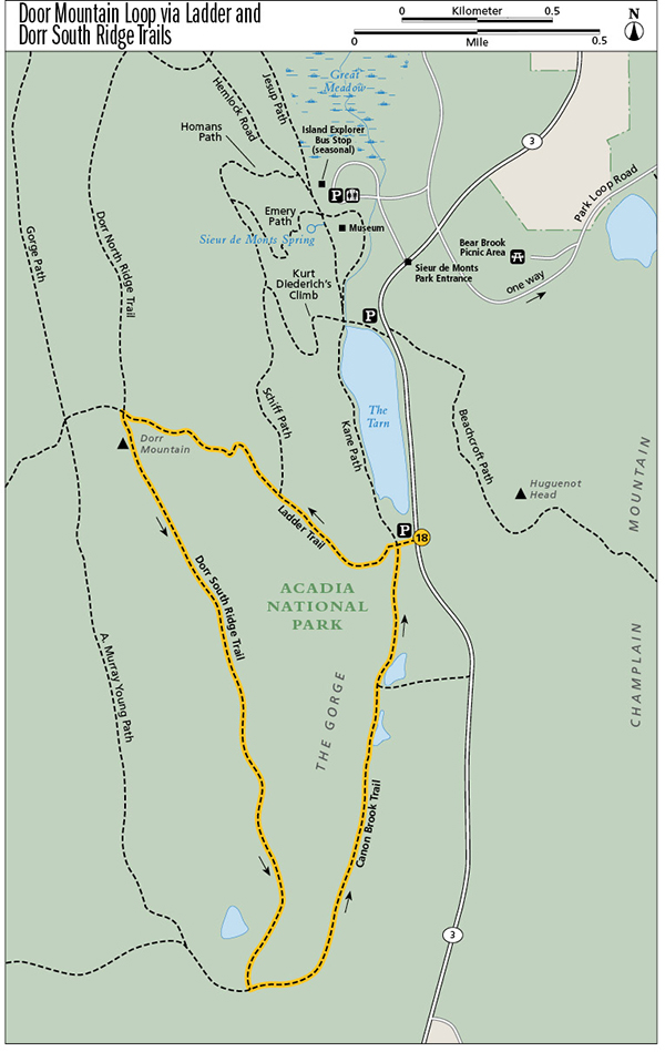
18 Dorr Mountain Loop via Ladder and Dorr South Ridge Trails
Variety abounds on this circuit: Go up Dorr via iron ladders and rungs, come down the mountain’s open south ridge, and circle around via a relatively easy section of the Canon Brook Trail that may have been part of a pre–Revolutionary War route. This is one of a couple dozen hikes featured in the park service handout “Paths into the Past: Acadia’s Historic Trails.”
Distance: 3.3-mile loop
Hiking time: About 3 to 4 hours
Trail surface: Iron rungs and ladders, granite steps, forest floor, rock ledges
Best season: Spring through fall
Other trail users: Hikers climbing to and from the Featherbed and Cadillac Mountain
Canine compatibility: Dogs prohibited on the Ladder Trail
Map: USGS Acadia National Park and Vicinity
Special considerations: No facilities
Finding the trailhead: Drive about 2.6 miles south of downtown Bar Harbor on ME 3, past the Sieur de Monts park entrance and the Tarn parking lot, to the first gravel pullout south of the mountain pond, on the right (west) side of ME 3. The trailhead is on the right (west) side of ME 3. The Island Explorer’s Sand Beach and Loop Road lines stop at Sieur de Monts, requiring an 0.8-mile hike to the trailhead via the Kane and Jesup Paths. GPS: N44 35.18' / W68 20.43'
The Hike
This challenging circuit offers nontechnical climbing up iron ladders and rungs, panoramic views from Dorr’s open south ridge, and an opportunity to walk along historic routes, part of which may have been a Native American carry trail to Otter Creek.
Beginning at the Ladder Trail, one of the most challenging ways up Dorr Mountain with its alternating iron ladders, rungs, and hundreds of stone steps, you immediately rise above the gorge between Dorr and Champlain Mountains, getting views of the Porcupine Islands to the northeast.
Quite a feat for its day, this trail was originally constructed under the leadership of architect Herbert Jaques, one of the big early trail builders in the 1890s on the island, along with George B. Dorr and Waldron Bates. The Civilian Conservation Corps showed a great care for detail in a massive reconstruction of this trail in 1934 and 1935, during the Great Depression. Some of the granite steps are fitted into narrow rock crevices or built to bring you up rock faces that would otherwise be impassable without full climbing gear.
The Dorr South Ridge Trail brings ever-closer views of Otter Cove and the Cranberry Isles.
Soon you’ll squeeze through a crevice and see an iron bar at the end, placed to keep you from falling off a cliff. Look sharp left and you’ll see the first iron ladder bolted into sheer rock, with its ten rungs and hinged sections. Be careful climbing this ladder. It’s safer to use the iron handholds to the left rather than grabbing the ladder rungs to pull yourself up and risk getting your fingers caught between the rock and the rungs.
Next comes a series of five metal rungs set into rock with more handrails, then another multistep ladder. At times the trail snakes between cavelike structures formed by a jumble of huge boulders or under rock overhangs that take on shapes limited only by your imagination.
The trail continues on scores of granite steps. You can still hear ME 3 below. You know you’re nearing the top of the Ladder Trail when it starts to level off beyond a series of granite steps and iron rungs.
At 0.4 mile reach the junction with Schiff Path. Bear left (northwest) to continue up Dorr on Schiff. You’ll begin to get views of the Tarn below, as well as of Champlain Mountain, Frenchman Bay, and the Porcupines farther to the east and northeast. The trail alternates between open ridge and scrub oak and pitch pine, then climbs steeply to the ridge. Follow the historic Bates-style cairns and blue blazes to the top.
At 0.9 mile, at the intersection with Cadillac-Dorr and Dorr South and Dorr North Ridge Trails, turn left (south) onto Dorr South Ridge Trail.
At 1.0 mile reach the 1,270-foot summit of Dorr. To the east are Champlain and Frenchman Bay. To the northeast are the Porcupine Islands, with Cadillac Mountain to the west. To the south are Otter Cove, the Cranberry Isles, and the Gulf of Maine.
Go straight (south) on the Dorr South Ridge Trail, getting ever-closer views of Otter Cove and the Cranberry Isles as you head down the classic Acadia pink granite, dotted with historic Bates-style cairns and blue blazes to point the way.
At 2.3 miles, as Dorr South Ridge ends, turn left (east) at the junction with the Canon Brook Trail to loop around the base of Dorr Mountain.
At 3.0 miles reach the junction with Kane Path. Stay straight (north) on Kane to continue the loop rather than bearing right, as the Canon Brook Trail heads east toward ME 3.
At 3.3 miles return to the Ladder trailhead, closing the loop. The pullout parking on ME 3 is to the right (east).
Miles and Directions
0.0Start at the Ladder trailhead, on the right (west) side of ME 3 south of the Tarn. You’ll be looping back on the return on the section of Kane Path that comes in from the left (south).
0.4Reach the junction with Schiff Path. Bear left (northwest) on Schiff to continue the climb.
0.9Attain the ridge of Dorr at an intersection with Cadillac-Dorr and Dorr South and North Ridge Trails. Turn left (south) onto Dorr South Ridge Trail.
1.0Summit Dorr Mountain. Continue straight (south) on Dorr South Ridge Trail.
2.3The Dorr South Ridge Trail dead-ends at the Canon Brook Trail. Turn left (east) onto the Canon Brook Trail to loop back.
3.0Head straight (north) onto Kane Path rather than following the Canon Brook Trail to the right (east).
3.3Arrive back at the Ladder trailhead, closing the loop. The pullout parking area on ME 3 is to the right (east).