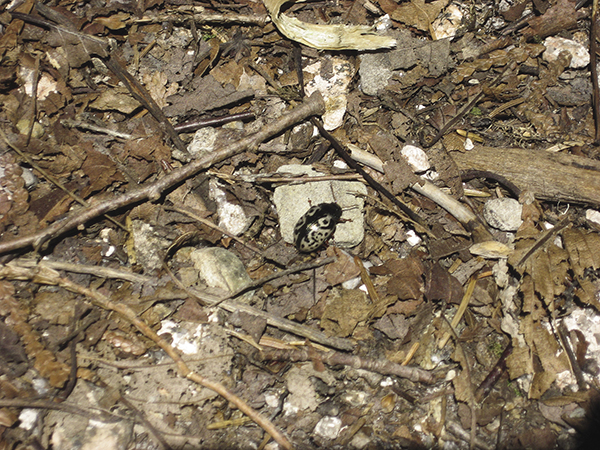
Calligrapha leaf beetle.
48 Sargent Mountain Loop via Giant Slide and Grandgent Trails
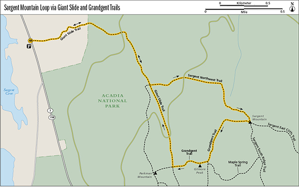
This strenuous loop combines sections of a few trails for a traverse along huge boulders and rock slabs at the bottom of a giant slide and then up the open summit of Sargent, Acadia’s second-highest peak. You’ll also bag less-visited Gilmore Peak, nestled between Sargent and Parkman Mountains.
Distance: 5.2-mile lollipop
Hiking time: About 3.5 to 4.5 hours
Trail surface: Ravine, granite steps, wooden bridges, forest floor, rock ledges
Best season: Spring through fall
Other trail users: Hikers climbing Gilmore Peak
Canine compatibility: Leashed dogs permitted but not recommended on the Giant Slide Trail
Map: USGS Acadia National Park and Vicinity
Special considerations: No facilities
Finding the trailhead: From Bar Harbor head west on ME 233 for 4 miles, then turn left (south) onto ME 198 for 0.9 mile. The recently moved Giant Slide trailhead is on the left (east) side of ME 198; park along the highway. The Island Explorer does not have a stop here, although the Brown Mountain line travels ME 198 on its way between Bar Harbor and Northeast Harbor; ask to be let off at the trailhead if it is safe to do so. GPS: N44 35.00' / W68 30.17'
The Hike
Deceivingly easy at first, the hike begins relatively flat.
The Giant Slide Trail starts by winding through a mossy forest and along some extensive trail work to protect the terrain—fifty-two sections of log bridges, each 6 to 7 feet long, known as bog walks. Soon you’ll climb a short series of granite steps to an amazing sea-green-colored, lichen-terraced landscape. Here a sign cautions Fragile habitat: Please stay on the trail before it explains how lichen is made up of two different plants, alga and fungus, and can take decades to recover if trampled.
Calligrapha leaf beetle.
After crossing a carriage road at 0.7 mile and following the trail to the right (southeast), you start the challenging climb up through the beginnings of the Giant Slide, around and under large boulders and slabs, squeezing through crevices and clambering by trees and ferns growing on rocks on the thinnest cover of soil. If you hike after heavy rains, Sargent Brook’s cascades and waterfalls can make for a wet and wonderful show along here, but the footing can be treacherous.
At 1.4 miles reach the junction with the Parkman Mountain Trail coming in on the right (west) and the Sargent Northwest Trail (Sargent North Ridge Trail) on the left (east). The Giant Slide Trail goes straight ahead at this junction, through a narrow, seemingly impassable, passageway between two rock walls (you’ll be squeezing through there on the way back). Turn left here to take the Sargent Northwest Trail up the steep face of Sargent.
The Sargent Northwest Trail brings you immediately across what can be a wide, rushing Sargent Brook after heavy rains. Ascend steeply as the trail switchbacks through the forest.

A rock overhang challenges hikers on this portion of the Sargent Mountain loop.
At 1.7 miles cross a carriage road, climb stone steps, and continue along the Sargent Northwest Trail on the other side. As the trail keeps going up steeply, you get your first views to the left (west) of Eagle Lake. If you hike this trail in late spring, you’ll also see an explosion of purple flowers known as rhodora. In late summer there’s a burst of goldenrods.
The trail dips then ascends along an open ridge with views all around. Keep your eyes out for the distinctive Bates-style cairns that mark the trail, especially along the bare rock ledges, to avoid losing your way.
At 2.4 miles reach the 1,373-foot summit of Sargent, second highest behind only Cadillac. Here you get spectacular 360-degree views of Somes Sound and Western Mountain to the right (west), the Cranberry Isles and the Gulf of Maine to the south, Pemetic and Cadillac Mountains to the east, and Porcupine Islands and Frenchman Bay to the northeast.
The area around Sargent Mountain is also noted for its red mountain cranberries—called lingonberries in certain parts of Europe, as a family we met here told us while they picked the berries in early August. Look closely, because the tiny berries are buried behind thick green leaves.
The summit also marks the junction of the Sargent East Cliffs, Sargent South Ridge, and Grandgent Trails. Take the rightmost trail (Grandgent) to head west off Sargent and loop back via Gilmore Peak and the Giant Slide Trail.
The Grandgent Trail is another one of Acadia’s historic memorial paths, named for Charles Hall Grandgent, chair of Harvard’s Romance language department, Southwest Harbor summer resident, and chair of the Southwest Harbor Village Improvement Association in the 1920s and 1930s.
At 2.9 miles reach the junction with the Maple Spring Trail. Turn right (west), cross the brook on a nice footbridge to continue on the Grandgent Trail, and reach Gilmore Peak at 3.0 miles.
While this 1,036-foot peak is less visited than either the higher Sargent to the northeast or the more easily accessed Parkman Mountain or Bald Peak to the west and southwest, its views are definitely not second fiddle. From Gilmore—the lowest of the park’s eight mountains 1,000 feet or higher—you can see west to Somes Sound, Echo Lake, and Long Pond, and east to Sargent.
Descend steeply down Gilmore along loose rock, reaching the junction with the Giant Slide Trail at 3.2 miles. Turn right (north) to loop back through the Giant Slide.
At 3.5 miles cross a carriage road diagonally to the right to continue northwest on the Giant Slide Trail. Follow Sargent Brook, crossing from one side to the other. Watch your step on the moss-covered rocks, even as you admire a sheer rock wall that towers above on the right (east).
The trail gets rougher. Squeeze between the tumbled-down slabs of granite, and clamber over the boulders of Giant Slide. At 3.8 miles loop back to the junction with the Sargent Northwest Trail coming in from the east and Parkman Mountain Trail coming in from the west.
Stay straight (northwest) on the Giant Slide Trail, recrossing the first carriage road at 4.5 miles and looping back to the trailhead at 5.2 miles.
Miles and Directions
0.0Start at the Giant Slide trailhead, on the east side of ME 198.
0.7Cross a carriage road and follow the trail as it curves right (southeast).
1.4Reach the junction with the Sargent Northwest Trail (Sargent Mountain North Ridge Trail) and Parkman Mountain Trail. Turn left (east) onto the Sargent Northwest Trail toward Sargent Mountain.
1.7Cross a carriage road.
2.4Summit Sargent and reach the junction with the Sargent East Cliffs, Sargent South Ridge, and Grandgent Trails. Turn right onto the Grandgent Trail and head west off the peak.
2.9Reach the junction with the Maple Spring Trail. Bear right (west) to continue on the Grandgent Trail.
3.0Summit Gilmore Peak.
3.2Reach the junction with the Giant Slide Trail. Turn right (north) to loop back.
3.5Cross a carriage road.
3.8Return to the junction with the Sargent Northwest and Parkman Mountain Trails. Go straight (northwest) to stay on the Giant Slide Trail.
4.5Cross a carriage road and follow the trail as it curves left (west).
5.2Arrive back at the Giant Slide trailhead.