
A view of the Cranberry Isles near the summit of Valley Peak.
56 St. Sauveur Mountain and Valley Peak Loop
The actual peak of St. Sauveur is wooded, but some cliffs 0.1 mile from the summit offer great views of Somes Sound, Sargent and Penobscot Mountains, and the Cranberry Isles. This loop takes you from St. Sauveur along the cliffs to Valley Peak and back.
Distance: 2.5-mile lollipop
Hiking time: About 1.5 to 2.5 hours
Trail surface: Wooden bridge, forest floor, rock ledges
Best season: Spring through fall
Other trail users: None
Canine compatibility: Leashed dogs permitted
Map: USGS Acadia National Park and Vicinity
Special considerations: No facilities; seasonal facilities a short drive away at Echo Lake
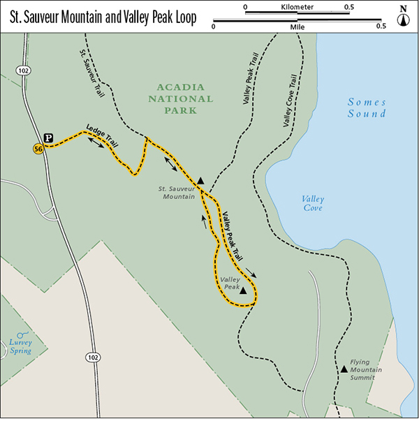
Finding the trailhead: From Somesville head south on ME 102 for 3.5 miles to a sign for St. Sauveur Mountain parking on the left (east) side of the road. The Ledge trailhead is at the south end of the parking area. The closest Island Explorer bus stop is at Echo Lake Beach on the Southwest Harbor line just south of the St. Sauveur Mountain parking; ask the bus driver to let you off if it is safe to do so. GPS: N44 31.18' / W68 33.17'
The Hike
The Ledge Trail is the shortest route to wooded, 679-foot St. Sauveur Mountain, not the official start of the St. Sauveur Trail over by the Acadia Mountain trailhead. This loop also provides an easier way to access the limited views on Valley Peak than does the official Valley Peak trailhead.
From the Ledge trailhead at the southern end of the St. Sauveur Mountain parking area, go left over a wooden bridge and then left along a rock face. Climb gradually up stone steps to a junction at 0.1 mile with a now-closed section of the Ledge Trail. Bear right (east) toward St. Sauveur Mountain. The trail climbs fairly steeply here up a wooded mountainside, with rocks and roots along the way. Follow the blue blazes along the rocky ledges for which the trail is named.
A view of the Cranberry Isles near the summit of Valley Peak.
At 0.6 mile reach a junction with the St. Sauveur Trail. Turn right (southeast). Reach the wooded summit of St. Sauveur Mountain—once called Dog Mountain—at 0.8 mile.
Continuing straight (southeast) on the St. Sauveur Trail, reach a fork at 0.9 mile. Take the left (east) fork and reach the Valley Peak Trail and the cliffs overlooking Somes Sound at 1.0 mile. Turn right (south) along the cliffs, and enjoy the views down to Valley Cove and south and southeast to Southwest Harbor and the Cranberry Isles.
At 1.3 miles reach the 530-foot summit of Valley Peak. Over the course of a decade, we’ve seen trees grow and block much of the view from here, but you can still get glimpses to the south of the ocean and the Cranberry Isles.
Bear right (northwest) to circle back to St. Sauveur Mountain on the St. Sauveur Trail rather than continuing to follow the Valley Peak Trail on its steep descent to Valley Cove Fire Road.
Return to St. Sauveur’s summit at 1.7 miles. Turn left (southwest) back onto the Ledge Trail at 1.9 miles, and arrive back at the parking area at 2.5 miles.
Miles and Directions
0.0Start at the Ledge trailhead, on the south end of the St. Sauveur Mountain parking area.
0.1Bear right (east) at an old junction with a now-closed section of the Ledge Trail.
0.6Reach another junction; turn right (southeast) onto the St. Sauveur Trail.
0.8Summit St. Sauveur Mountain. Continue straight (southeast) on the St. Sauveur Trail.
0.9Reach a fork. Take the left (east) fork toward the Valley Peak Trail and cliffs overlooking Somes Sound.
1.0Reach the Valley Peak Trail and turn right (south) along the cliffs.
1.3Reach the summit of Valley Peak. Bear right (northwest) at the trail junction to loop back toward St. Sauveur Mountain on the St. Sauveur Trail.
1.7Return to St. Sauveur Mountain.
1.9Turn left (southwest) onto the Ledge Trail to return to the parking area.
2.5Arrive back at the Ledge trailhead.