This short hike, initially following the Intemann Trail, climbs to the summit of 7,361-foot Red Mountain, where you’ll find commanding views of Manitou Springs and Pikes Peak.
Distance: 3 miles out and back
Hiking time: 1 to 2 hours
Difficulty: Moderate; 800-foot elevation gain
Trail surface: Doubletrack and singletrack dirt trail
Best season: Mar through Nov; icy in winter
Other trail users: Hikers only
Canine compatibility: Dogs permitted
Fees and permits: No fees or permits required
Maps: USGS Manitou Springs
Trail contacts: Manitou Springs Public Services Department, 606 Manitou Ave., Manitou Springs, CO 80829; (719) 685-5481; www.manitouspringsgov.com/government/departments/planning/post
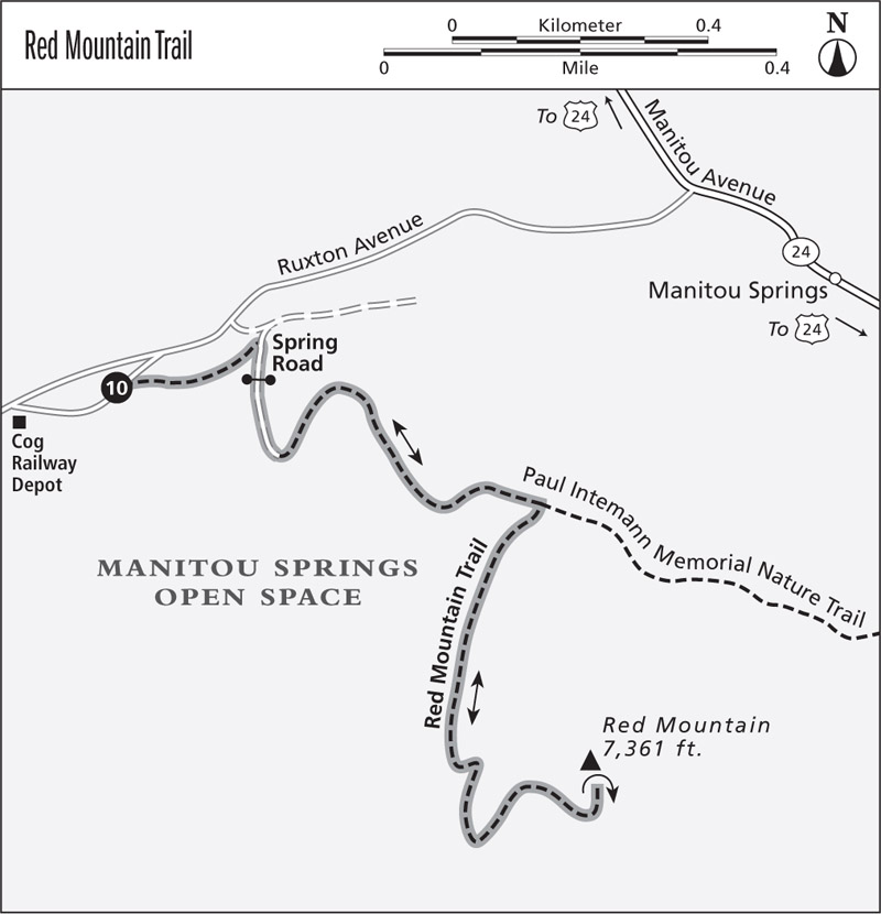
Finding the trailhead: The hike begins at the Iron Springs trailhead by Iron Springs Chateau in Manitou Springs. From Colorado Springs drive west on US 24 and take the first exit for Manitou Avenue. Drive west on Manitou Avenue to a roundabout and turn left onto Ruxton Avenue, following signs for the Pikes Peak Cog Railway. Follow Ruxton until it splits into a one-way road to the cog railway depot and a oneway street back to Manitou Avenue. Go right and follow the road to the depot; make a U-turn left onto the return one-way street. Find a paid parking place to park here or along the right side of Ruxton Avenue. Parking is problematic in summer. It’s best to park at a free lot at 10 Old Man’s Trail on the east side of Manitou, and take a free shuttle between 6 a.m. and 6 p.m. to the trailhead. The Iron Springs trailhead for the Paul Intemann Memorial Nature Trail is on the right, just before Ruxton becomes a two-way street. GPS: 38.857289, –104.927498
Red Mountain, a low peak rising above Manitou Springs, offers a great hike to some of the area’s best views. Despite the mountain’s steep slopes, the trail wends to the peak’s 7,361-foot summit with gradual grades that switchback across the steepest slopes. Besides fun hiking and great views, Red Mountain offers a surprise ending—the remains of a restaurant, casino, and summit house of an incline railway.
Begin your adventure at the Iron Springs trailhead next to Ruxton Avenue below the Pikes Peak Cog Railroad station and the Iron Springs Chateau. After finding a parking spot on either Ruxton Avenue or Iron Springs Road, which can be a problem during the busy summer tourist season, hike east on a trail along the south side of Ruxton Creek past the Iron Springs, a mineral spring under a pavilion on the north bank of the creek. Continue down the trail to Spring Road and go right onto the road.
Walk up the dirt road to a gate, and pass onto the Inte-mann Trail. The first 0.5-mile segment of this hike follows the Paul Intemann Memorial Nature Trail, a trail that contours east above Manitou Springs. The trail is named for Paul Intemann, a Manitou Springs city planner who envisioned a network of trails above Manitou. He died in a car accident in New Mexico in 1986.
Follow the closed road up a draw, around a blunt ridge, and up a broad vale toward a couple of power poles. Look to the right before the poles for a sign marking the start of the Red Mountain Trail. This 1-mile spur trail, built by volunteers in 1999 and 2001, is on a swath of Manitou Springs Open Space land.
Turn right (south) and hike up the Red Mountain Trail, which slowly climbs southwest in a mixed conifer forest of ponderosa pine and Douglas fir left of a steep ravine. Follow the trail as it switchbacks up the steep slope until it swings left and climbs to a saddle on a ridge. This is the official end of the trail but not the hike.
Go left at the saddle and continue up the rocky trail, which threads above the steep eastern flank of Red Mountain. After climbing 50 feet, the trail ends on the mountain’s flat summit.
The summit of 7,361-foot-high Red Mountain offers wonderful views. Below nestles Manitou Springs, with houses lining its hilly roads. The distant sounds of traffic, barking dogs, and music filter upward. To the east rise the red rocks of Garden of the Gods, and beyond spreads the prairie horizon. The westward view is spectacular. Pikes Peak rears high above. Lower, the pinnacles Gog and Magog perch on a long ridge.
The top of Red Mountain, however, is not just about views. If you look around, you’ll see the concrete foundations of several buildings erected here in the early twentieth century. The Red Mountain Incline Railway ferried visitors up the mountain’s steep northeast face. The lower concrete footings mark where the railway ended and visitors disem-barked. The upper foundations mark the former site of a restaurant, bar, and dance hall, where both live music and whiskey flowed. Some even say it was a casino and a gentlemen’s club—a polite way of saying it was a brothel—but that’s just rumor.
Before the railway, Red Mountain’s summit was a gravesite. In the nineteenth century, Manitou Springs was a healing place for tuberculosis patients, who came for the dry air and healing springs. Young Emma Crawford came for the cure in 1889 but died in 1891 at the age of 19. She once hiked to the summit, where she had a vision and left a scarf tied on a tree by her chosen burial plot. After Emma’s death, her fiancé and twelve pallbearers carried her coffin up Red Mountain and buried her on top. In 1912 the coffin was moved to the south so that the summit house could be built. After heavy rains in 1929, Emma’s coffin washed down the mountain, spilling her remains. She was reburied in a Manitou cemetery, but many locals say that her ghost stalks Red Mountain and some have seen the Victorian-clad specter. Every October, Manitou Springs hosts a coffin race in her honor.
After brooding on the summit about this history, turn around and retrace your steps 1.5 miles back down the trail to the trailhead.
| 0.0 | Start at the Iron Springs trailhead for the Paul Intemann Memorial Nature Trail (GPS: 38.857289, –104.927498). |
| 0.1 | Go right at the junction with Spring Road. |
| 0.15 | Come to a junction with a road. Pass through a gate and go right on the Intemann Trail. |
| 0.5 | Go right at the junction with Red Mountain Trail. |
| 1.5 | Reach the summit of Red Mountain, your turnaround point (GPS: 38.8514, –104.9212). |
| 2.5 | Return to the junction with the Intemann Trail. Go left. |
| 3.0 | Arrive back at the trailhead. |