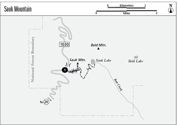
1 Sauk Mountain
A half-day hike to Sauk Mountain, 4.2 miles round-trip, or a day hike or short backpack to Sauk Lake, 6.2 miles round-trip.
Best season: Mid-May to mid-October; Sauk Lake opens mid-June.
Elevation gain: 1,040 feet to Sauk Mountain.
Elevation loss: 1,170 feet to Sauk Lake.
Maximum elevation: 5,541 feet at the summit of Sauk Mountain.
Topo maps: Sauk Mountain; Lake Shannon.
Jurisdiction: Mount Baker–Snoqualmie National Forest.
Finding the trailhead: Follow Washington Highway 20 to Rockport State Park, just west of Rockport. Drive north on Sauk Mountain Road, an improved gravel road that winds upward for 8 miles to the trailhead.
The Hike
This trail makes a short but challenging ascent to the summit of Sauk Mountain on the seaward edge of the North Cascades. Views are surprisingly inspiring from here, encompassing Mount Baker and Puget Sound as well as the glacier-carved peaks of the Cascades. A spur trail makes a long descent from the heights to reach Sauk Lake, where there are several camping spots. Both the lake and the summit of Sauk Mountain can be reached in a hard half day of hiking.
The trail begins at timberline, zigzagging steadily up a wide but steep couloir. Avalanches have cleared away the trees here, clearing a space for a magnificent display of alpine wildflowers. Glacier and avalanche lilies dominate the early season just after snowmelt, and are overtopped by lupine, Indian paintbrush, monkeyflower, penstemon, and many others as the summer progresses. From the slopes, one can look out across the Skagit and Sauk river valleys, with the lofty summit of Whitehorse Mountain rising to the southwest. The icebound volcanic cone of Mount Baker becomes visible near the top of the grade.
The path tops out in a grassy saddle in the rocky cockscomb of Sauk Mountain. Splendid westward views stretch from the high volcanic summit of Glacier Peak north along the western scarp of the Cascade Mountains and into Canada. Strange tors of basalt rise along the crest of Sauk Mountain itself, and small way trails wander among them. The main trail traverses high across the eastern face of the peak, and soon the Sauk Lake spur trail drops away to the right. The Sauk Mountain route glides up to a bald knob that offers superb northward views of Mount Shuksan.
The trail then crosses the talus slopes beneath a series of sharp pinnacles. Watch for tiny pikas scurrying among the broken shards of rock. The path soon climbs into a saddle and then ascends one of the pinnacles, where it reaches its end. Hikers get an unobstructed vista of Mount Baker from this point, and on an exceptionally clear day one can see the Olympic Mountains to the west and Mount Rainier to the south.
Miles and Directions
0.0Sauk Mountain Trailhead.
1.4Trail reaches ridge crest.
1.6Junction with spur trail to Sauk Lake (1.5 miles, moderate). Bear left for summit of Sauk Mountain.
2.1Trail ends atop one of the crags of Sauk Mountain.
Sauk Lake Option
From a signpost high on the flanks of Sauk Mountain, this spur path descends steadily across meadow-strewn slopes. The trail slumps away in spots, making for treacherous footing. The path soon seeks an eastward-trending spur ridge and follows it downward past odd sinkholes bordered by mats of pink heather. As it enters a sparse growth of trees, the trail passes several fine overlooks of the Skagit Valley. It then turns north, still descending, to pass through a notch that overlooks Sauk Lake. Beyond the notch, the trail traverses a talus slope where marmots make their dens. The path zigzags down toward the lake, then levels off and traverses small patches of brush to reach the low rise at its foot. This rise is an old terminal moraine, bulldozed into place by a long-extinct montane glacier that once gouged the lake basin out of the mountainside. Camping spots are secluded in the trees atop the moraine; camp so that your tent is not visible to hikers atop Sauk Mountain.
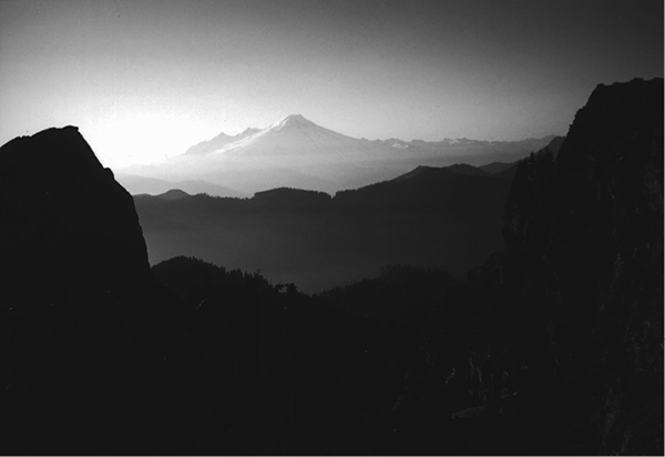
Mount Baker from the top of Sauk Mountain