81 Bridge Creek
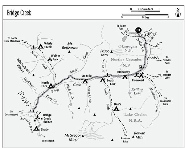
A backpack along Bridge Creek from Washington Highway 20 to the Stehekin Valley Road, 11.1 miles total.
Best season: Early July to mid-October.
Elevation gain: 800 feet (north to south).
Elevation loss: 3,030 feet (north to south).
Maximum elevation: 4,400 feet at the PCT South Trailhead.
Topo maps: Washington Pass, McAlester Mountain, McGregor Mountain; Washington Pass, Stehekin, McGregor Mountain.
Jurisdiction: North Cascades National Park.
Finding the trailhead: The hike begins at the Pacific Crest Trail (PCT) South trailhead, at mile 159.2 on WA 20, 2 miles east of Rainy Pass. The trail emerges on the Stehekin Valley Road, 4.3 miles above High Bridge.
The Hike
This major thoroughfare links WA 20 with the Stehekin Valley via a moderate descent along Bridge Creek. This is one of the fastest and easiest routes into the Stehekin and, unlike the ferries and floatplanes that serve this remote settlement, the Bridge Creek Trail costs nothing. Possible side trips that depart from this trail include Dagger Lake, McAlester Lake, Rainbow Lake, and North Fork Meadows. The trail terminates near the Bridge Creek camp; from here, hikers can catch the shuttle bus to Stehekin for a small fee.
From the trailhead, cross the highway on the east bank of Bridge Creek to reach an unmarked trail junction. The path that crosses the creek from the west is the Pacific Crest Trail (PCT); turn left to follow it down Bridge Creek. The trail makes its way through a subalpine forest, following the highway for a time and then veering southward. The trail soon splits in two, and the resulting trails follow both banks of Bridge Creek. There is a camp spot to the left, and this trail continues southward to link up with the Stiletto Peak and Dagger Lake Trails. Turn right for the Bridge Creek Trail, which descends to cross Bridge Creek before turning southward.
Old-growth grand and subalpine fir grow along the banks of the stream as the trail makes its way southward, and water ouzels flit along the rushing waters. The path traverses the lower slopes of Frisco Mountain, crossing avalanche scars that reveal views of Stiletto Peak to the east. Later, there are views down the valley toward the outlying buttresses of Bowan Mountain. Stands of tall timber alternate with the brushfields, and in the sunny forest openings the blooms of columbine, tiger lily, and lupine light the understory. As the valley bends around onto a westward heading, the trail passes a ruined cabin that was once part of the Sulphide Mine, which produced small quantities of silver and lead during the 1920s.
The path then makes its way across a broad brushfield that occupies an old landslide scar. Debris from the slide is piled up along the banks of Bridge Creek near its confluence with McAlester Creek. After returning to the timber, a connecting trail runs east past the Fireweed camps to join the McAlester Lake and Dagger Lake Trails. The Bridge Creek Trail continues down the valley, descending gently across avalanche-scarred slopes north of the creek. As the path approaches Hideaway Camp, the crags of Memaloose Ridge become visible above the distant trees. The camp itself is down on the streambank in a secluded grove of conifers.
The trail now levels off, crossing open brushfields punctuated by narrow stringers of conifers and groves of black cottonwood. The granite heights of Frisco Mountain now rise above the trail, and tantalizing glimpses can be had of the more jagged crags down the valley. After crossing Frisco Creek, the brushfields offer views up the South Fork of Bridge Creek, with Bowan Mountain and the eastern outliers of McGregor Mountain above its headwaters. The path soon descends to a junction with the Rainbow Lake Trail; follow this side trail to the banks of Bridge Creek to reach the South Fork camps.
Beyond the junction, the path runs below timbered slopes. Although open slopes surround the trail, there will be no distant views for the next 3 miles. A spur trail soon descends through the nettles to reach Six Mile Camp in a picturesque creekside grove of spruce. The main trail now ascends gently across the mountainside, rising ever higher above Bridge Creek. The reason for the ascent becomes apparent as the path descends toward Maple Creek: the waters of Bridge Creek have cut an impenetrable gorge through the mountains, and jagged ribs of bedrock rise hundreds of feet above the water, barring all passage.
Maple Creek itself presents quite a spectacle, foaming down a torrential series of cascades beneath a forbidding landscape of cliffs and talus. A hiker bridge is suspended above the stream during the summer months, just above the horse ford. The trail then climbs again to reach a level pad that overlooks the main gorge. There are good views of the defile as the path continues its traverse across the high slopes, with occasional stands of Douglas fir to provide patches of shade. Nearing the North Fork of Bridge Creek, the trail wanders out onto rounded slopes covered in ceanothus, allowing good views of the ragged summits to the west. It then descends steadily along the crest of a low ridge that separates the merging valleys. Lodgepole pine now dominates the landscape. The junction with the trail to North Fork Meadows is on an elevated bench between the streams; North Fork Camp is down at the confluence beside a striking waterfall on the North Fork.
A bridge now spans the main channel of Bridge Creek, and the trail will complete its journey on the south bank of the stream. Climbing across a rock face, the path reveals fine views of Mount Benzarino across the valley. After a brief ascent, the trail finds itself above a rocky gorge again. Just beyond Berry Creek, intervening hillocks screen off the main valley, and the path runs through a narrow depression. The trees open up at the lip of a small, dry gorge that is overlooked by the stony countenance of McGregor Mountain. A backward glance reveals farewell views of Mount Benzarino and the rocky toe of Memaloose Ridge.
The trail passes a stagnant pond, then runs level through the forest to an overlook with views up the Stehekin Valley, featuring Booker, Sahale, and Johannesburg Mountains, in order of increasing distance. The trail then loops downward through the Douglas firs to reach its terminus on the Stehekin Valley Road, between Bridge Creek and the camp of the same name.
Miles and Directions
0.0 PCT South Trailhead.
0.1 Junction with PCT inbound from Rainy Pass. Bear left.
0.8 Junction with trail that follows east bank of Bridge Creek. Turn right, following signs for the PCT.
0.9 Trail crosses Bridge Creek and follows west bank.
1.4 Trail enters North Cascades National Park.
2.5 Ruins of sulphide mining claim.
3.1 Junction with trail to Fireweed Camp, Dagger Lake, and McAlester Pass. Bear right.
4.0 Spur path descends to Hideaway Camp.
5.1 Trail crosses Frisco Creek.
5.5 Junction with trail to South Fork camps and Rainbow Lake. Continue straight ahead.
6.2 Spur path descends to Six Mile Camp.
6.7 Upper end of Bridge Creek gorge.
7.6 Maple Creek crossing.
9.2 Junction with North Fork Meadows Trail. Continue straight ahead.
9.5 North Fork Camp. Trail crosses Bridge Creek and follows south bank.
10.5 Berry Creek crossing.
11.1 Stehekin Valley Road.