Falls Near Cedar Camp
84 Agnes Creek—Pacific Crest Trail
A backpack from the Stehekin Valley to Suiattle and Cloudy Passes, 21.7 miles one way.
Best season: Early July to early October.
Elevation gain: 6,440 feet.
Elevation loss: 1,640 feet.
Maximum elevation: 6,440 feet at Cloudy Pass.
Topo maps: McGregor Mountain, Mount Lyall, Agnes Mountain, Holden; McGregor Mountain, Holden.
Jurisdiction: Lake Chelan National Recreation Area, Glacier Peak Wilderness (Wenatchee National Forest).
Finding the trailhead: The trail leaves the Stehekin Valley Road between High Bridge and High Bridge Camp.
The Hike
This well-maintained segment of the Pacific Crest Trail (PCT) starts in the Stehekin Valley, then penetrates the heart of the Glacier Peak Wilderness. It follows the tumbling waters of Agnes Creek through bottomlands of old-growth conifers, with scant views of the mountains until the trail rises to the timberline at the head of the valley. Here, trails run over Suiattle Pass for views of Glacier Peak and over Cloudy Pass to link up with the trail that follows Railroad Creek to the retreat village of Holden. The trail receives few visitors until early September, when PCT through-hikers arrive on the scene.
The trail begins by descending to a bridge that spans Agnes Creek, which carries the volume of a small river. Hikers gain superb views of McGregor Mountain to the east and Goode Mountain to the north as the path leaves the Stehekin Valley, climbing moderately through open timber to avoid the cliffs of Agnes Gorge. A high perch overlooks the mouth of the gorge, and beyond it the trail completes its lazy climb and turns westward up the Agnes Creek valley. The route passes several impressive stands of old-growth cedar as it makes its way into the Glacier Peak Wilderness. There is a campsite at mile 2.5, where the roar of cataracts rises through the trees from the gorge below. Adventurous souls can bushwhack along an abandoned path to reach a cliffside aerie that offers clear views of the chasm and its thundering falls.
Meanwhile, the main trail continues up the valley, rising and falling through a sparse woodland of Douglas fir and white pine. This latter tree rarely reaches maturity, falling prey to white pine blister rust as it reaches its full stature. There are tantalizing glimpses of Agnes Mountain, partly hidden by the treetops. The first major tributary is Pass Creek, bordered by ancient cedars and hemlocks. Just beyond it is Five Mile Camp, and the junction with the abandoned West Fork Trail.
The Agnes Creek Trail follows the great southward bend of the valley, climbing moderately as it moves inland. Sparse stands of pine and Douglas fir indicate the locations of old burns. These breaks in the forest provide more glimpses of Agnes Mountain, but there is no clear view until the trail reaches the low gorge and waterfalls on the South Fork of Agnes Creek. The path soon returns to the forest, providing occasional glimpses of the water. Mossy groves of hemlock, pure stands of silver fir, and open woodlands of spruce and Douglas maple form a patchwork that is typical of a healthy forest ecosystem. Impressive groves of cedar appear as the trail approaches Swamp Creek. There is a camp here, but the trail that once ran east along this tributary has all but disappeared.
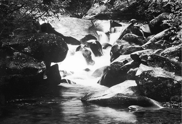
Easy trekking through the forest leads to Cedar Camp, where Spruce Creek pours in from the west. Agnes Creek now steepens its gradient, plunging through a series of small cascades formed by sills of resistant stone. The old-growth forest is breached by an avalanche slope as the trail passes the pale cliffs of Mount Blankenship. A larger brushfield farther on unveils the surreal spires of Needle and Dark Peaks, while Saddle Mountain presents massive gables of rock on the west side of the valley. After climbing a rise, the forest takes on a subalpine character. The path then drops into the creek bottoms, where Hemlock Camp is sited in a superb stand of old-growth silver fir and western hemlock.
Falls Near Cedar Camp
Just beyond camp, the trail forks. The left fork is the old Agnes Creek Trail, which cuts off distance at the expense of scenery. It follows the creek through a boggy forest to reach the passes at the head of the valley. When snow covers the high country, it is the better option. The right fork is the preferred route, which will chart a high course across the western wall of the valley for superb views of the surrounding peaks.
It begins by following the South Fork through a strange and wonderful forest where stout trees grow atop massive boulders that have tumbled from the face of Saddle Bow Mountain. An ankle-deep ford leads across the creek, and soon the trail begins a long and steady upward grade. As it breaks out of the forest into open brushfields, the sawtooth crests of Needle and Dark Peaks rise to the east, while the snow-dappled summit rising ahead is Sitting Bull Mountain. After leveling off briefly, the trail continues its ascent through the subalpine forest across from Sitting Bull. After a long detour into a nameless side valley, the trail reaches the open bowl at its head. There are breathtaking waterfalls here, and now the summit of Bonanza Peak can be seen beyond the toe of North Star Mountain. A low but rocky backbone links North Star with Cloudy Peak, which rises farther to the south.
Watch for marmots and pikas as the trail traverses southeast beneath the ramparts of Sitting Bull. The path soon resumes its climbing, ascending onto a high spur covered in heather. The journey is accompanied by fine views of Cloudy Peak and the indignant bleats of pikas, and there is a developed camp below the trail just before it enters a grove of ancient mountain hemlocks. After crossing a boulderfield overgrown with anemones and other wildflowers, the trail begins a substantial descent into the basin at the foot of Plummer Mountain. Enormous boulders, some larger than a house, have crashed down from the towering cliffs to fill the floor of the basin. After threading its way through the fractured rock, the trail ascends into the forest for the final trek to the head of the valley. It reaches a signpost just 500 vertical feet below Suiattle Pass.
If it is raining or you are in a hurry to reach Cloudy Pass, turn left. Otherwise, bear right for a visit to Suiattle Pass followed by a steep and narrow traverse across the head of the Agnes Creek valley to Cloudy Pass. This route climbs steadily through heather-blueberry parklands and can be quite slippery when wet. After passing a camping area, the trail doglegs eastward to cross over the pass. After a short descent, there are jaw-dropping views of Glacier Peak as well as the jagged crest of Fortress Mountain to the east of it. After a few downward switchbacks, turn left onto the path that crosses through the lowest point on Suiattle Pass.
This trail soon descends across steep slopes, unveiling superb views down the South Fork of Agnes Creek as it bypasses a granite face. The track then climbs steeply, joining the main trail on its purposeful ascent to Cloudy Pass. The meadows below the pass offer views of Plummer and Sitting Bull Mountains, while the tundra at the summit commands sweeping vistas of the upper basin of Railroad Creek, with its broad glaciers, majestic peaks, and sparkling lakes. From Cloudy Pass, the Railroad Creek Trail descends to the tiny village of Holden.

Miles and Directions
0.0 Trailhead on Stehekin Valley Road.
0.2 Bridge over Agnes Creek. Trail now follows south bank.
2.0 Trail enters Glacier Peak Wilderness.
2.5 Campsite at junction with old spur to abandoned Agnes Gorge bridge.
4.8 Trail crosses Pass Creek.
4.9 Five Mile Camp. Junction with abandoned West Fork Trail. Bear left.
8.1 Trail crosses Swamp Creek to arrive at Swamp Creek Camp. Junction with abandoned Swamp Creek Trail. Follow main trail.
9.5 Cedar Camp.
12.4 Hemlock Camp. Junction with Upper Agnes Creek Trail (5.5 miles to upper junction). Turn right to follow preferred route.
12.7 Trail fords the South Fork of Agnes Creek.
14.7 Alpine basin below Sitting Bull Mountain.
16.3 Trail reaches camping area.
16.7 Upper junction with Upper Agnes Trail. Turn left to proceed directly to Cloudy Pass; turn right to follow preferred route via Suiattle Pass.
19.5 Suiattle Pass Camp.
20.0 Trail crosses Suiattle Pass.
20.3 Junction with cutoff trail to Cloudy Pass. Turn left.
20.6 Route re-crosses Suiattle Pass.
21.0 Junction with Upper Agnes Trail. Turn right for Cloudy Pass.
21.7 Cloudy Pass. Railroad Creek Trail runs eastward toward Holden.