
Looking toward Sahale Mountain from McGregor Mountain
85 McGregor Mountain
A brutal day hike or backpack from the Stehekin Valley to the summit of McGregor Mountain, 15.4 miles round-trip.
Best season: Late July to mid-October.
Elevation gain: 6,552 feet.
Elevation loss: None.
Maximum elevation: 8,122 feet at the summit of McGregor Mountain.
Topo maps: McGregor Mountain (trail not shown); McGregor Mountain.
Jurisdiction: North Cascades National Park.
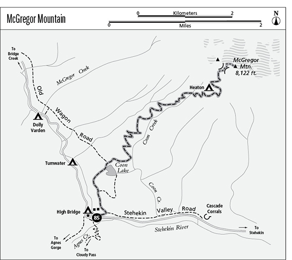
Finding the trailhead: The trail departs from the old High Bridge guard station, behind the buildings.
The Hike
This trek is for hikers who wish to push their limits and challenge themselves physically and mentally. A long climb leads from the floor of the Stehekin Valley to the base of the final pitch, which is an abandoned trail that is hard to locate and has dangerous dropoffs all the way to the summit. There is no easy way to approach this trek. Backpackers can camp at Heaton Camp near the top of the grade, but hauling a full pack all the way up to this lofty aerie is a daunting prospect. Hikers who attempt the summit in a single day will be biting off more than 14 miles of steep trail, with scrambling and route-finding challenges thrown in at the top of the grade.
The trail begins by ascending the wooded benches to the east of High Bridge. Mountain views start early on this trail, with good views up Agnes Creek toward the sharp spires of Agnes Mountain. After a short distance, the Coon Lake horse trail departs to the right for even better views before reaching a bluff above the south shore of the lake. The main trail climbs northward through the ponderosa pines and Douglas firs to reach the western shore of Coon Lake. This rare mountain wetland is an important staging area for waterfowl.
The trail rounds the north side of the lake and climbs to the base of McGregor Mountain. A long series of switchbacks carries the hiker ever upward through the scattered trees. There is a good overlook as the trail approaches Coon Creek, which tumbles down steep bedrock in a delightful waterfall. Views continue to improve as the trail climbs. Upon reaching an open shelf of rock at the 3,680-foot level, hikers gain views of the glacier-bound summit of Dome Peak to the west as well as Booker and Buckner Mountains to the north. The rocky crags of McGregor Mountain tower high overhead, and the trail now snakes upward across ponderosa pine and Douglas fir savannahs. This plant community is typical of valley bottoms on the arid eastern side of the Cascades, and its occurrence at such a high altitude is quite unusual. It attests to the warm and snow-free microclimate enjoyed by this south-facing slope.
Looking toward Sahale Mountain from McGregor Mountain
The trail soon passes a steep gorge on Coon Creek, then swings away from the stream. The next encounter with the stream comes in a narrow and brushy couloir that is swept free of timber by frequent avalanches. The trail now redoubles its climb, ascending pitilessly up the chute. Subalpine fir and larch announce the approach to the alpine zone, and lush swards of wildflowers soon carpet the streambanks. The trail ultimately rises into a barren bowl, filled with broken rock and guarded by the stark cliffs of McGregor Mountain. Watch for pikas amid the talus.
The trail then swings north onto a rocky arm, where it encounters Heaton Camp huddled in a ragged grove of larch and fir. Views from here encompass Sahale Mountain to the northwest, Mount Lyall to the southwest, and between them the distant and snowy crest of Glacier Peak beyond a sea of lesser crags. Above the camp, the trail continues upward, and finally peters out as a recognizable path atop the heather fellfields at the base of the cliffs.
The scramble route to the summit is really no more than a goat track, following cairns and arrows painted onto the rock up the loose scree and across narrow cliff ledges. Hikers with strong climbing and route-finding skills may find the route by looking due east, straight uphill from the cairn at the trail’s end. A convex talus fan leads up to two couloirs that come slanting in from opposite directions. Climb southward across the talus, then traverse to the base of the left-hand (north) couloir to find the unmarked track slanting southward up a ledge of stone. The track snakes upward, rarely requiring handholds as it swings across open faces and ascends rocky spurs in preference to the looser rock of the couloirs.
The track reaches the mountaintop at a notch between major peaks; views extend eastward over barren crags and spires as far as the eye can see. The route now turns south across the top of Sandalee Glacier, then returns to the ridgeline at a low gap just below the summit. Follow the painted arrows up the spine of the ridge to reach the radio repeater that occupies an old fire lookout site on the summit. Views from here encompass most of the peaks within a 50-mile radius; highlights include Goode Mountain and Mount Logan to the north as well as the head of Lake Chelan to the south.
Miles and Directions
0.0 Trailhead at old High Bridge guard station.
0.2 Junction with horse trail to Cascade Corrals. Bear left.
0.4 Junction with horse trail to south shore of Coon Lake. Bear left.
1.1 Coon Lake.
1.2 Junction with Old Wagon Road Trail. Turn right as trail begins ascent of McGregor Mountain.
2.1 Waterfall on Coon Creek.
6.6 Heaton Camp. Trail climbs above timberline.
7.3 End of maintained trail. Steep scramble route leads upward to summit.
7.7 Summit of McGregor Mountain.