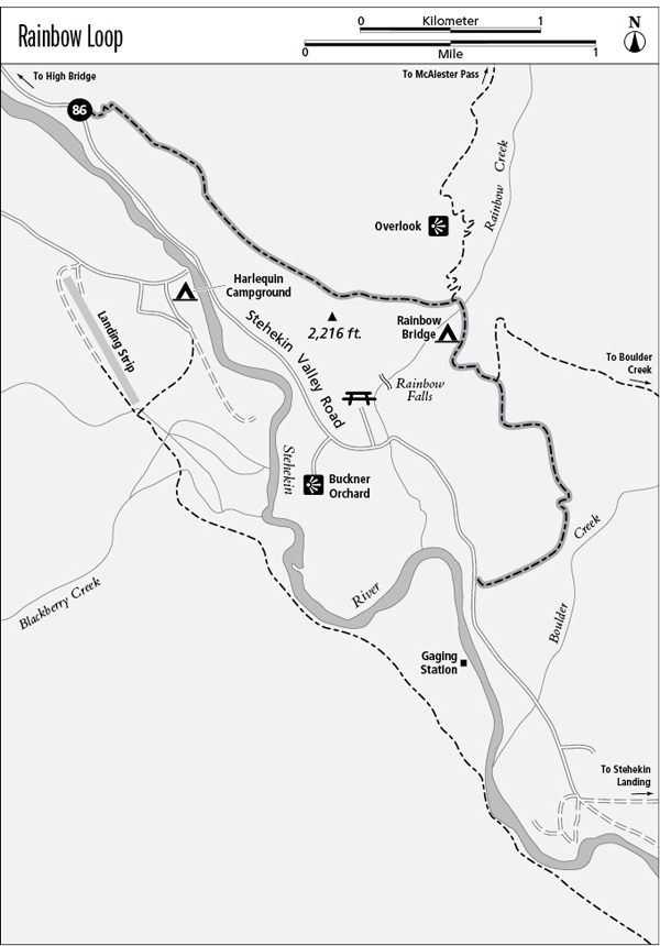
86 Rainbow Loop
A half-day hike onto mountainsides above the Stehekin Valley, 4.6 miles one way.
Best season: Mid-June to mid-October.
Elevation gain: 1,050 feet (north to south).
Elevation loss: 1,090 feet (north to south).
Maximum elevation: 2,180 feet.
Topo maps: Stehekin; Stehekin.
Jurisdiction: Lake Chelan National Recreation Area (North Cascades National Park).
Finding the trailhead: Take the shuttle or hike the Stehekin Valley Road. The upper trailhead is 5 miles above the Stehekin landing, and the lower trailhead is 3 miles above the Stehekin landing.
The Hike
The Rainbow Loop offers a rather short day trip that climbs onto the middle slopes of the mountains for views of the Stehekin Valley and the peaks that guard it. The journey is made chiefly by visitors who lack the time or inclination to attempt the more challenging day hikes in the area. It is easiest when approached from the north. An extra 1-mile climb up the Rainbow Creek Trail leads to a high viewpoint that looks south across the head of Lake Chelan.
The trail begins by climbing modestly but steadily through a shady forest of Douglas fir. Bigleaf maples occupy the wetter swales, and in early October they burst into a colorful display of fall foliage. On the way up, talus slopes provide glimpses of the surrounding country. Just after the trail completes its initial climb and begins traversing southward, a bedrock overlook below the trail provides panoramic views of the Stehekin Valley, where the river winds through its forested bottoms. The steep-walled peaks beyond the river are outriders of Sisi Ridge and Tupshin Peak.
After a long level stretch, the trail begins climbing once more. There is another viewpoint at the edge of a grassy hillside, after which the trail climbs to the top of a timbered platform. Now winding east into the Rainbow Creek drainage, the path crosses a grassy meadow dotted with ponderosa pines. The junction with the Rainbow Creek Trail is at the far edge of this meadow; follow it upward for 1 mile to reach a lofty overlook. Hikers who are pressed for time should skip the climb and follow the Rainbow Loop southward as it descends to cross a bridge over Rainbow Creek. There is a shady camping area on the far bank of the stream.
The slopes above the camp are studded with Douglas firs that are dying from heavy infestations of parasitic mistletoe. The mistletoe, often called “witch’s broom,” causes twigs to grow in ball-shaped masses. Tupshin Peak rises dead ahead as the trail surmounts the next finger ridge, and atop the ridge is a rocky clearing overlooking the Buckner Orchard. McGregor Mountain rises prominently to the north. After passing a junction with the Boulder Creek Trail, the Rainbow Loop embarks on a steady grade that leads down the mountainside through stands of Douglas fir and groves of bigleaf maple. It soon arrives at a clifftop perch that faces southward across the head of Lake Chelan. A long and steady descent leads to the mouth of the Boulder Creek valley. Here, the trail turns west to descend the gentle slopes that lead down toward the Stehekin River. The last portion of the trek runs through a sunny woodland to reach a trailhead on the Stehekin Valley Road.
Miles and Directions
0.0 North Trailhead.
2.4 Junction with Rainbow Creek Trail. Stay right for loop.
2.6 Trail crosses Rainbow Creek.
2.8 Rainbow Bridge Camp.
3.2 Junction with Boulder Pass Trail. Stay right.
4.6 South Trailhead.
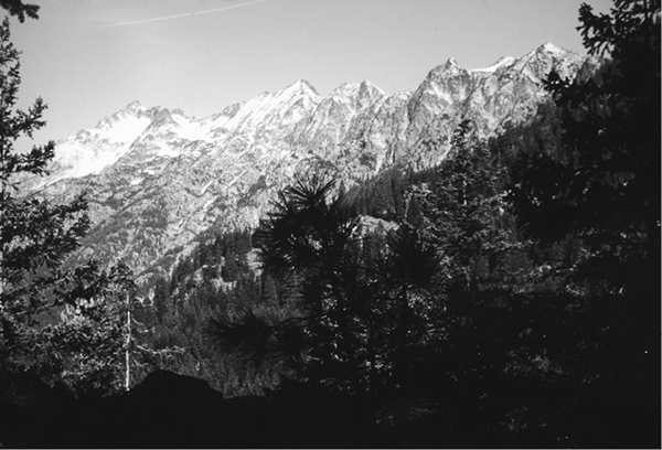
McGregor Mountain from the Rainbow Loop