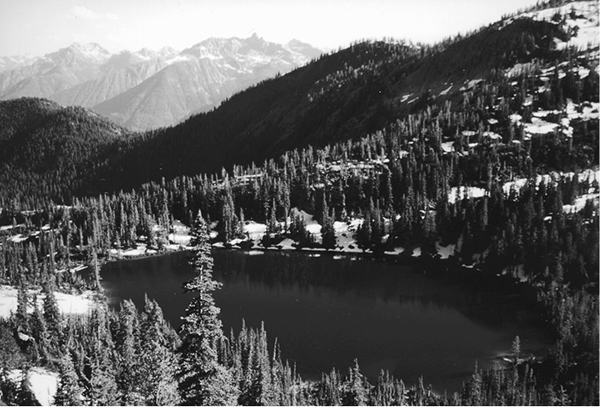
Rainbow Lake
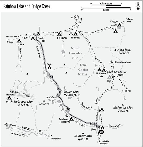
88 Rainbow Lake and Bridge Creek
A backpack from Stehekin to Rainbow Lake via the Rainbow Creek Trail (10.5 miles one way) or an extended trip from Rainbow Creek over a high pass to Bridge Creek (9.8 miles total).
Best season: Late July to mid-October.
Elevation gain: 2,770 feet (south to north).
Elevation loss: 3,270 feet (south to north).
Maximum elevation: 6,230 feet at the pass above Rainbow Lake.
Topo maps: McGregor Mountain, McAlester Mountain; Stehekin, McGregor Mountain.
Jurisdiction: Lake Chelan National Recreation Area, North Cascades National Park.
Finding the trailhead: The trail leaves the Rainbow Creek Trail at mile 5.5, just before Bench Creek Camp. It joins the Bridge Creek Trail at its halfway point near South Fork Camp.
The Hike
This trail links Rainbow and Bridge Creeks via a high pass at the foot of Bowan Mountain, visiting the beautiful alpine tarn called Rainbow Lake along the way. It is most often traveled by backpackers during the course of extended forays into the backcountry to the east of the Stehekin Valley.
From the junction at Bench Creek camp, the Rainbow Lake Trail descends steeply to reach a ford of Rainbow Creek. In midsummer, the water is knee-deep and runs at a moderate pace. During spring runoff, the crossing is all but impassable.
On the far bank, the trail climbs onto open, south-facing slopes where ceanothus and kinnikinnick are the dominant plants. There are excellent views down-valley, featuring the sharp summit of Castle Rock. As the trail zigzags heartily upward, views across the Rainbow Creek valley reveal the rocky summits extending southward from McAlester Mountain. A few scattered clumps of Douglas fir provide spots of shade, but for the most part the trail grinds upward under the heat of the sun. It ultimately seeks the banks of the North Fork of Rainbow Creek, and the ascent moderates as the trail follows the stream upward into a subalpine woodland of spruce and fir.
The first of several grassy meadows soon interrupts the forest, and the trail finds the Rainbow Meadows hiker camp in the trees a short distance beyond it. More expansive meadows lie ahead, filled with the blossoms of lupine, aster, and paintbrush. The horse camp occupies the lower edge of the second meadow, and there are more campsites beyond the third and largest meadow. Each of the meadows was created by avalanches from the rocky ridge above them, and periodic snowslides prevent the forest from encroaching into the openings.
Rainbow Lake
The trail then begins to ascend the eastern wall of the valley, and old-growth hemlock and subalpine fir soon give way to open slopes. The trail zigzags upward at a purposeful pace, lit by the blossoms of penstemon. At the top of the grade, one can look southwest over a saddle in the intervening ridgetop for fine views of the glacier-mantled summit of Dome Peak. Agnes Mountain is the barren summit to the left of it, and the sawback ridges and the sentinel spire of Mount Lyall are visible above the ridgetop. The path now levels off and runs northwest across open slopes, with fine views of Rainbow Meadows and increasingly unobstructed vistas of Mount Lyall as well as of Tupshin Peak to the west of it.
Straight ahead, a waterfall courses across a rounded face of granite, heralding the approach to Rainbow Lake. This alpine gem is guarded by cliffs of white granite, the outliers of McGregor Mountain. The rugged summit of Bowan Mountain guards the eastern shore of the lake. Marmots cavort among the meadows and boulders at the foot of the lake, and there is a camping area on the far side of the outlet stream. Anglers will find that the waters are stocked with small rainbow and cutthroat trout.
From the foot of the lake, the trail zigzags up onto the talus apron below Bowan Mountain, then turns west for the final climb to a high pass. There are fine aerial views of the lake as the trail ascends, a fitting foreground for the broad panorama of peaks to the south. After crossing the divide, the path drops through a larch-heather community on its way toward the headwaters of the South Fork of Bridge Creek. Looking northward, hikers gain distant views of Black Peak, flanked by the lesser summits of Mount Benzarino to the left and Corteo Peak to the right. As the slope steepens, the path drops onto the western slope of Bowan Mountain, descending across a broad face of talus.
The trail bottoms out in a boggy meadow, which is fed by a beautiful waterfall that hangs in silver tresses down the cliffs to the east. A subalpine forest awaits at the meadow’s edge, and the trail drops through it, following the banks of the rushing stream. After a brief descent, the trail levels off to cross an avalanche path, revealing the multiple peaks of McGregor Mountain lining the head of the valley. Look backward here for fine views of Bowan Mountain’s solitary miter. The path then disappears into the forest once more for the long and zigzagging descent to the South Fork of Bridge Creek. Near the bottom of the grade, avalanche slopes offer astounding views of McGregor Mountain, with the pocket icefields of Sandalee Glacier draped across its north face.
The trail levels off in a meadow at the bottom of an avalanche track, and soon it reaches the banks of the South Fork. Just after entering North Cascades National Park, the trail encounters Dan’s Camp in a stand of old spruce and fir. This is one of the few shady spots on the valley bottom; most of the forest has been periodically thinned by avalanches and low-intensity fires. The trail descends gently but steadily down the valley, finally reaching the main branch of Bridge Creek in a stand of old-growth spruce and cedar. A footlog leads to the South Fork hiker camp on the far bank, and the horse camp lies just beyond it. The trail then climbs into a brushfield to reach its end at a junction with the Bridge Creek Trail.
Miles and Directions
0.0 Junction with Rainbow Creek Trail at Bench Creek Camp.
0.4 Trail fords Rainbow Creek and climbs stiffly.
2.8 Rainbow Meadows hiker camp.
3.2 Rainbow Meadows horse camp.
3.5 Last campsites in the meadows. Trail starts climbing.
4.7 Top of grade.
5.0 Rainbow Lake.
5.7 Trail crosses pass into the valley of the South Fork of Bridge Creek.
7.0 Trail leaves Lake Chelan NRA and enters North Cascades National Park.
7.1 Dan’s Camp.
9.6 Trail crosses Bridge Creek to reach South Fork hiker camp.
9.7 South Fork horse camp.
9.8 Trail ends at junction with Bridge Creek Trail.