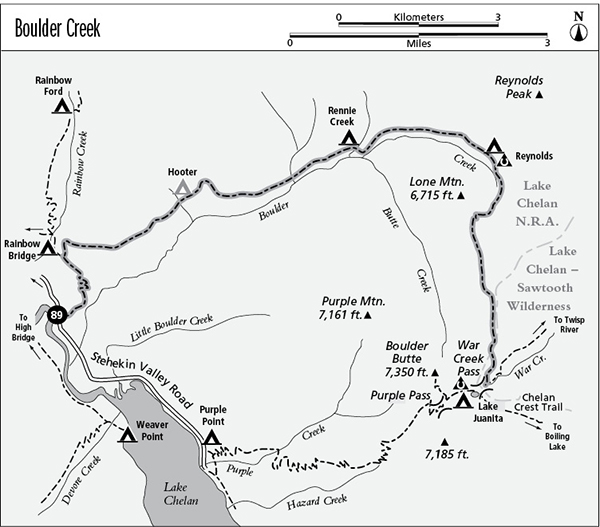
89 Boulder Creek
A backpack from the Stehekin Valley to Lake Juanita via War Creek Pass, 11.4 miles one way.
Best season: Early July to mid-October.
Elevation gain: 6,140 feet.
Elevation loss: 650 feet.
Maximum elevation: 6,920 feet (above Butte Creek).
Topo maps: Stehekin, Sun Mountain; Stehekin.
Jurisdiction: Lake Chelan National Recreation Area (North Cascades National Park), Lake Chelan–Sawtooth Wilderness (Okanogan National Forest).
Finding the trailhead: Take the shuttle bus or walk to the Rainbow Loop lower trailhead, at mile 3.2 on the Stehekin Valley Road.
The Hike
This primitive trail ascends into the valley of Boulder Creek and follows it to the timberline, where a steep climb leads over the high passes and into the Lake Chelan–Sawtooth Wilderness. The Boulder Creek drainage was the site of an immense wildfire during the summer of 1994, and although its tread was unaffected by the blaze, the trail has not received intensive maintenance since; deadfalls may bar the way. This fact, coupled with the insanely steep grades at the end of the trail, make this backdoor route to the Chelan Summit a lightly traveled one.
The trek begins on the lower leg of the Rainbow Loop, which climbs the gentle and loosely wooded slopes to reach the base of the mountains, then zigzags upward. There are several fine overlook points on the way to the junction with the Boulder Creek Trail, first offering views of Lake Chelan and the Buckner Orchard, and later a northward vista of McGregor Mountain. The Boulder Creek Trail departs on a northward heading atop a wooded shelf, climbing first through a shady stand of Douglas fir and later across grassy slopes. High on the mountainside, there are excellent views of Castle Rock and Tupshin Peak, and glimpses of Lake Chelan.
After a stiff 1-mile climb, the trail enters the Boulder Creek valley and the ascent eases (but does not cease). The route now enters the edge of the 1994 Boulder Creek burn. Here, the fire burned with low intensity and a number of thick-barked Douglas firs were able to survive. Openings in the trees allow views up the valley; the jagged summit at its head is Reynolds Peak. The trail soon crosses a small stream and arrives at Hooter Camp, where a single tent pad has been carved out of the mountainside.
The trail now levels off for a time, passing across rocky and open slopes that offer the trek’s best views of Tupshin Peak. It soon enters the heart of the burn, climbing steadily to maintain an altitude about 100 feet above Boulder Creek. The middle reaches of the valley are tedious and toilsome. The former forest has been transformed by fire into broad grasslands that offer scant relief from the heat of the sun. The old Rennie Camp was heavily damaged by the fire. Its trailside tent pads, easy to miss, are below the trail as it approaches Rennie Creek. This large stream is bordered by picturesque walls of bedrock.
The trail soon passes the mouth of the Butte Creek valley, guarded to the east by Lone Mountain. The next major stream to be reached is nameless but is of enormous ecological significance in that it served as a natural firebreak during the Boulder Creek fire. Beyond it lies an unburned subalpine woodland of spruce and fir. The trail now exacts a heavy toll, climbing ever steeper as the valley makes its bend to the southeast. Grassy meadows ultimately yield views of Reynolds Peak, and the trail makes for its base to seek out Reynolds Camp. The camp is sited beside a picturesque meadow that offers northward views of Rennie Peak, with the bald spur of McAlester Mountain in the distance.
Views improve as the path continues its steep ascent. Soon it reaches the grassy basin at the head of Boulder Creek; take on water here because the remainder of the trek offers none. The path now swings westward to make an insanely steep climb of the ridge behind Lone Mountain. Larch meadows near the top of the grade reveal parting views of Reynolds Peak and the Camels Hump to the south of it. Upon gaining the ridgetop, the trail swings onto the western face for a high traverse of burned-over slopes high above Butte Creek. The rugged peak across the valley is Boulder Butte, while the lofty summits of McGregor, Buckner, and Goode Mountains rise along the northern horizon.
A series of daunting upward pitches leads to the top of the War Creek divide, where hikers get southward views of Oval Peak as well as the lesser summit of Splawn Mountain at the head of the War Creek valley. The path now descends southward along the crest of the divide, then jogs west to avoid a rocky knoll. Here, an unburned stand of spruce and larch occupies a rocky corner of the Butte Creek watershed. Soon the trail climbs across the head of the War Creek drainage, leaving national park land for a brief excursion through a corner of the Lake Chelan–Sawtooth Wilderness, which is administered by the Forest Service. Just below War Creek Pass, the Boulder Creek route feeds into the War Creek Trail; turn right for the short jaunt over the pass to Lake Juanita.
Miles and Directions
0.0 Rainbow Loop south Trailhead.
1.6 Boulder Creek Trail splits away from Rainbow Loop. Turn right.
2.8 Top of initial grade.
3.1 Hooter Camp.
6.1 Rennie Camp.
6.2 Trail crosses Rennie Creek.
8.2 Reynolds Camp.
9.3 Trail reaches saddle behind Lone Mountain.
11.2 Trail crosses War Creek divide, leaves national park lands, and enters Lake Chelan–Sawtooth Wilderness.
11.4 Junction with War Creek Trail. Turn right for 0.2-mile hike to Lake Juanita.