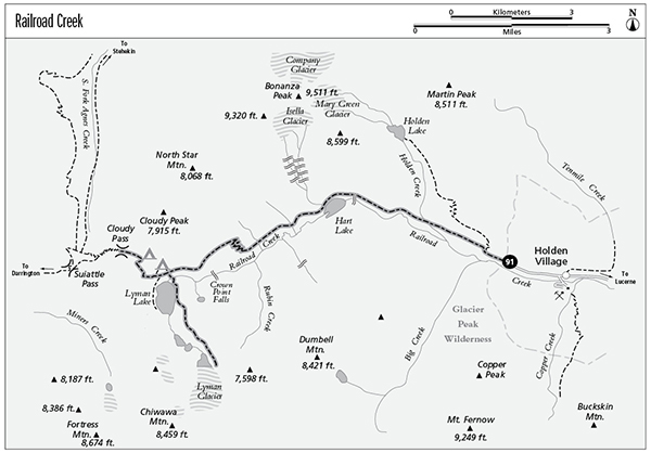
Lyman Glacier
91 Railroad Creek
A day hike from Holden to Hart Lake, 9.2 miles round-trip, or a backpack to Cloudy Pass, 9.7 miles one way.
Best season: Early July to early October.
Elevation gain: 3,575 feet.
Elevation loss: 361 feet.
Maximum elevation: 6,440 feet at Cloudy Pass.
Topo maps: Holden, Suiattle Pass; Holden.
Jurisdiction: Glacier Peak Wilderness (Wenatchee National Forest).
Finding the trailhead: Take the ferry to Lucerne and then the shuttle bus to Holden Village. The hike begins on the westbound Railroad Creek Road.
The Hike
This trail makes a long journey up Railroad Creek from the old mining camp of Holden Village to the alpine heights of Cloudy Pass. Railroad Creek got its name from the short inclined railway at the mouth of the valley, which transported copper ore down to waiting barges on Lake Chelan. The entire valley shows the influence of the miners: Early prospectors burned most of the timber in a quest for gold; the copper mine at Holden came later and brought settlement to the valley; and the old company town has become a Lutheran retreat that brings hundreds of visitors into the mountains annually. The Railroad Creek Trail offers an overnight getaway into the Glacier Peak Wilderness, replete with alpine lakes, waterfalls, glaciers, and superb mountain views throughout the trek.
The hike begins by following the gravel road that runs along the north bank of Railroad Creek, past the old ore-refining mill on the far bank and the stone curbs and stairways that are all that remain of the abandoned miner’s village. The road gives way to the trail at the wilderness boundary, and camping spots are scattered along the edge of a clearing. The sawtooth crest of Copper Peak reveals itself across the valley as the trail makes its way through a floodplain woodland of cottonwood and Douglas fir. After passing a junction with the Holden Lake spur, the main trail rises out of the bottomlands onto open slopes covered with willow and young aspen. Much of this valley was burned in the late 1800s by prospectors who sought to uncover veins of precious metals. Hikers get fine views of Copper Peak as the trail climbs steadily, then glides down to a footbridge over Holden Creek.
After passing through a stand of lodgepole pine, the trail breaks out onto the open slopes above a marshy flat. Beavers have constructed dams across Railroad Creek here, creating a number of ponds and canals. Shrubfields of mountain ash, Douglas maple, and willow now afford views of the craggy northern buttress of Dumbell Mountain. The trail soon undertakes a steady climb, passing quite close to a splendid cascade as Railroad Creek pours down the face of a gneiss outcrop. At the top of the grade, the trail reaches Hart Lake, and views open up to encompass Crown Point Falls at the head of the valley, with a rocky bulwark of Chiwawa Mountain rising beyond it. The trail crosses the rocky slopes above the lakeshore, passing a lone camping spot near the head of the lake. Here, a pretty peninsula rises across the water, clad in tall grasses and spruce copses. As the creek waters enter Hart Lake, they slow down and the coarse sediments settle out, extending the peninsula ever farther into the lake.
Lyman Glacier
The trail now climbs high onto an alluvial fan, formed by spectacular cataracts that descend from Isabella Glacier, which remains hidden from view. Dropping back into the creek bottoms, the trail passes a second series of waterfalls to reach Rebel Camp in a streamside grove of ancient spruce trees. A clearing filled with spiraea awaits beyond the camp, with spectacular views of Dumbell Mountain and the slender waterfalls that descend from its heights. The path soon ascends into heavy brush, beginning a long grade that carries travelers past the headwall that bears Crown Point Falls. There are excellent views of the falls from several overlooks as the trail zigzags upward, and the mountain scenery continues unabated. At the top of the grade, look back for the trail’s best views of Bonanza Peak.
The trail skirts subalpine firs beside a meadow-filled shelf, then switchbacks up beside a talus slope to surmount a second and smaller headwall. Upon reaching the upper basin, hikers pass a junction with the path to Lyman Glacier before reaching the foot of Lyman Lake. This vast and shallow lake is fed by the meltwaters of several glaciers, which contribute a finely ground silt that gives the lake its turquoise hue. Hanging Glacier can be seen on a rocky spur of Chiwawa Mountain, while the much larger Lyman Glacier is hidden behind a low bluff at the head of the lake. There is a large camping area in the mountain hemlocks above the trail, while a spur route rounds the western shore of the lake for additional mountain views.
Meanwhile, the main trail turns north, climbing through copses of spire-shaped subalpine firs. As it breaks out onto the broad meadows below Cloudy Pass, there is a small campsite in the trees to the east. The Railroad Creek Trail now swings westward for the final ascent to the pass. Views are spectacular along the way. The primeval upper basin of Railroad Creek is hemmed in by stark peaks, and Lyman Glacier and its lesser neighbors feed into shallow lakes. From the pass itself, hikers gain additional views of Plummer and Sitting Bull Mountains across the Agnes Creek drainage. From here, the Agnes Creek Trail descends into the valley beyond, and a cutoff path swings across the head of the valley toward Suiattle Pass.
Miles and Directions
0.0 Holden Village. Follow road westward.
0.3 Bridge to site of old Holden Mine. Continue straight ahead.
1.0 Road passes camping area and ends at wilderness boundary. Railroad Creek Trail runs westward from this point.
1.5 Junction with Holden Lake Trail. Bear left.
4.6 Trail reaches the foot of Hart Lake.
5.0 Campsite near the head of Hart Lake.
5.7 Rebel Camp.
6.2 Trail begins grade that leads to Lyman Lake.
8.6 Junction with Lyman Glacier Trail (2.2 miles, moderate). Continue straight ahead for Lyman Lake and Cloudy Pass; turn right for camping area.
8.7 Trail reaches foot of Lyman Lake.
8.9 Spur trail runs south along west shore of Lyman Lake. Turn right.
9.7 Cloudy Pass camping area.
10.1 Cloudy Pass. Connecting trails lead to Suiattle Pass and Agnes Creek.
Lyman Glacier Option
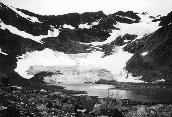
This narrow footpath is a must-see side trip for visitors who are camping at Lyman Lake. From the signpost, a footlog leads across Railroad Creek, whereupon the path climbs modestly onto a sparsely wooded bluff. There are fine views of Bonanza Peak to the northeast, and soon the trail offers panoramic vistas of Lyman Lake as it follows the eastern shore. As the trail climbs onto a tundra-clad rise, watch for even better views of Bonanza Peak’s austere towers. To the north a spectacular landscape unfolds, with the turquoise waters of Lyman Lake stretched full-length below the white summits of Cloudy and North Star Peaks. The twin peaks now visible through Cloudy Pass belong to Sitting Bull Mountain.
As the trail crests the rise, a primordial scene straight out of the Pleistocene epoch unfolds. Lyman Glacier lies at the head of the valley, descending from cliffs of iron-rich bedrock. Below it are a succession of terminal moraines, or ridges of waste rock bulldozed into place by the moving ice. They mark the successive surges and retreats of the glacier; some of the older moraines have become overgrown with heather and larch, while the more recent ones have dammed shallow meres of meltwater. The path runs eastward along the edge of the basin, then descends onto the outwash plain to reach an end at a cairn atop a sandy hillock. This perch offers superb views of the glacier’s terminus and of ice floes in the lake below its toe. The stark summit to the west is Mount Chiwawa; an upper lobe of Lyman Glacier graces its east face.