93 Chelan Lakeshore Trail
A long day hike or short backpack from Stehekin to Moore Point, at the mouth of Fish Creek, 13.6 miles round-trip.
Best season: Mid-April to early November.
Elevation gain: 1,050 feet.
Elevation loss: 1,060 feet.
Maximum elevation: 1,660 feet.
Topo maps: Stehekin, Lucerne, Sun Mountain; Stehekin, Lucerne.
Jurisdiction: Lake Chelan National Recreation Area (North Cascades National Park), Lake Chelan–Sawtooth Wilderness (Wenatchee National Forest).
Finding the trailhead: From Stehekin Landing, follow roads south past the Golden West Visitor Center and the fire cache to reach the marked beginning of the trail.
The Hike
This trail follows the eastern shore of Lake Chelan from the Stehekin visitor center all the way to the mouth of Prince Creek. This description covers only the first 6.5 miles of the trail, which offers the best scenery and is visited most often. The first 3.7 miles fall within National Park Service jurisdiction, beyond which the path travels through the Lake Chelan–Sawtooth Wilderness. There are privately owned parcels at various points along the lakeshore, and some have cabins on them. Treat them as private property. There are developed camping areas beyond Flick Creek (permit required) and at Moore Point, the end of the trek. Check yourself for ticks after the hike; they are particularly abundant in spring and early summer.
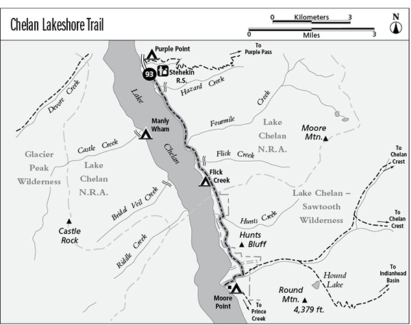
The trail begins as a level trek beside the water, with intermittent views of Castle Rock across the lake. There is a pretty waterfall at Hazard Creek, and just beyond it the trail runs out onto a rocky headland for superb views up and down the lake. Buckner Mountain is the snowy summit far up the Stehekin Valley, and its rocky neighbor is Booker Mountain. In the middle distance, McGregor Mountain presents an immense edifice of rock. The first major stream along the trail is Fourmile Creek, and the trail wanders inland here to cross an alluvial fan. Back on the lakeshore, the trail soon passes a private cabin and runs eastward into the woods to cross Flick Creek at the mouth of its rocky canyon. A moderate climb then leads to a grassy hilltop for more fine views of Lake Chelan. The Flick Creek shelter and camp occupy a sparsely wooded point farther to the south, offering a picnic spot with outstanding views.
After passing it, the trail leaves Lake Chelan National Recreation Area and enters the Wenatchee National Forest. The route now runs inland, climbing moderately through the trees. A side trip along Hunts Creek leads far to the east, after which the trail climbs onto a stony bluff for superb views of the head of the lake. The view continues to improve as the path charts a high and sometimes cliff-hanging course across the face of Hunts Bluff. To the southwest, magnificent crags rise in the Glacier Peak Wilderness beyond the settlement of Lucerne. The trail maintains its altitude to reach the great forested delta of Fish Creek. Pay attention to trail signs as the path crosses a jeep road and later as the Fish Creek Trail splits away to the left. The lakeshore trail first follows Fish Creek toward the lake, then crosses a sturdy bridge and splits. To the left, the Lakeshore Trail continues southward toward Prince Creek while our route follows a spur trail that runs down to meet Lake Chelan at Moore Point. This trail ends at a campground and boat landing that also boasts a log shelter.
Miles and Directions
0.0 Trail leaves Stehekin bearing southward along lakeshore.
0.5 Falls on Hazard Creek.
2.3 Trail crosses Fourmile Creek.
2.9 Trail crosses Flick Creek.
3.6 Flick Creek Camp.
3.7 Trail leaves Lake Chelan NRA and enters Lake Chelan–Sawtooth Wilderness.
4.4 Trail crosses Hunts Creek.
5.0 Trail reaches its highest point on Hunts Bluff.
6.1 Jeep track crosses trail. Continue straight ahead.
6.3 Junction with Fish Creek Trail. Bear right.
6.4 Trail crosses Fish Creek.
6.5 Junction with Moore Point spur trail. Turn right to complete the hike.
6.8 Moore Point camping area and boat landing.
Castle Rock from the Chelan lakeshore