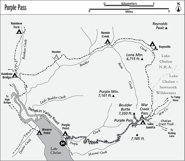
Looking through Purple Pass
94 Purple Pass
A backpack from the Stehekin landing to Lake Juanita, 8 miles one way.
Best season: Mid-July to mid-October.
Elevation gain: 5,810 feet.
Elevation loss: 305 feet.
Maximum elevation: 7,350 feet at Boulder Butte.
Topo maps: Stehekin, Sun Mountain; Stehekin.
Jurisdiction: Lake Chelan National Recreation Area.
Finding the trailhead: The hike begins on the Imus Creek Nature Trail, which starts directly behind the Golden West Visitor Center.
The Hike
This trail is a seemingly interminable climb from the north shore of Lake Chelan to the subalpine parklands at the north end of the Chelan Summit Trail. Much of the length of this trail burned in 2006 during the Flick Creek Fire, which was started by an illegal campfire and burned over 8,000 acres. Lake Juanita, a small and barren pond, lies at the end of the trek. The entire trail can be hiked in a single day, but it is a long and grueling journey. Backpackers commonly combine the Purple Pass trail with the Boulder Creek route for a two- to three-day loop trip.
The trail is approached via the Imus Creek Nature Trail. Hikers may begin from the road just north of Purple Point Campground, or from the trail sign behind the Golden West Visitor Center. The latter option is more scenic, visiting the cool riparian woodland where Purple Creek plunges over a sill of resistant gneiss.
From the trail junction at the upper edge of Purple Creek’s alluvial fan, the Purple Pass Trail begins its long and steady climb on the grassy slopes beside the mouth of a rocky canyon carved by the creek. Initial views across the lake feature Castle Rock and Tupshin Peak. As the path climbs higher, forest openings reveal the summit of White Goat Mountain as well. After a considerable ascent, the trail swings east into the Purple Creek canyon. The riparian woodland along the watercourse is comprised of water-loving hardwoods, dominated by bigleaf maple. Hikers can rely on this woodland for a colorful display of autumn foliage in early October.
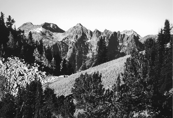
Looking through Purple Pass
After crossing Purple Creek, the trail runs south and soon climbs onto open savannahs populated by Douglas fir and ponderosa pine. Scenic overlooks are commonplace as the trail makes a hot upward trek. To the north, a long vista up the Stehekin Valley is highlighted by the barren crags of McGregor Mountain and the more distant summits of Sahale and Booker Mountains. Views of Lake Chelan stretch southward as far as the settlement of Lucerne, below the wooded dome of Domke Mountain.
After almost 4 miles, the path runs eastward into the Hazard Creek drainage, still climbing. The ponderosa pines now fall behind, and views constrict to encompass only the peaks directly across the lake. Along the way, a signpost marks an abandoned trail that once accessed Cougar Spring; this path has been obliterated by a tangle of game trails and thickets of spiny hawthorn. Continuing upward, the trail ultimately rises to crest the ridgetop, which offers panoramic views. After a short climb, the path swings onto the high slopes above Purple Creek. The Douglas firs are now replaced by a sparse woodland of subalpine fir, whitebark pine, and ultimately larch.
The final climb to Purple Pass is accompanied by expanded northward views, highlighted by the upthrust finger of Goode Mountain and the snowy massif of Mount Logan to the east of it. Grassy parklands stretch southward from the pass, interspersed with tidy copses of larch and spruce. As the path descends from the pass, there are fine views across the head of the Fourmile Creek basin, which is guarded to the east by Splawn Mountain and to the south by massive Moore Mountain. The poorly marked trail to Boulder Butte soon splits away to the left, while the main path continues its descent into the meadows beside Lake Juanita. There is a horse camp to the west of this small and shallow pond, while the hiker’s camp occupies a rocky shelf along the south shore with splendid views of the surrounding peaks. A trail junction on the east shore of the lake offers access to Boulder and War Creeks (to the left) and the Chelan Summit Trail (straight ahead).
Miles and Directions
0.0 Golden West Visitor Center. Follow Imus Creek Nature Trail.
0.1 Trail crosses Purple Creek below waterfall.
0.2 Purple Pass trail splits away from Imus Creek Nature Trail. Turn right.
1.9 Second crossing of Purple Creek.
4.9 Abandoned spur trail descends to Cougar Spring.
6.0 Top of ridge.
7.4 Purple Pass.
7.6 Junction with Boulder Butte spur (0.5 mile, moderately strenuous). Stay right for Lake Juanita.
7.9 Lake Juanita camps.
8.0 Junction beside Lake Juanita. War Creek Trail runs northeast; Chelan Summit Trail runs southeast.
Boulder Butte Option
This nearly forgotten but well-worn spur trail departs from the Purple Pass trail 0.2 mile east of the pass. It first runs northward across slopes of broken rock that are sparsely populated by subalpine larch. Watch for pikas as the trail crosses an east-facing bowl, then zigzags up to the summit of Boulder Butte. An old lookout site at 7,350 feet commands stunning views in all directions, encompassing McAlester Mountain to the northwest, Sun Mountain looking southward along Sawtooth Ridge, and the head of Lake Chelan with a crowd of crags rising beyond it.