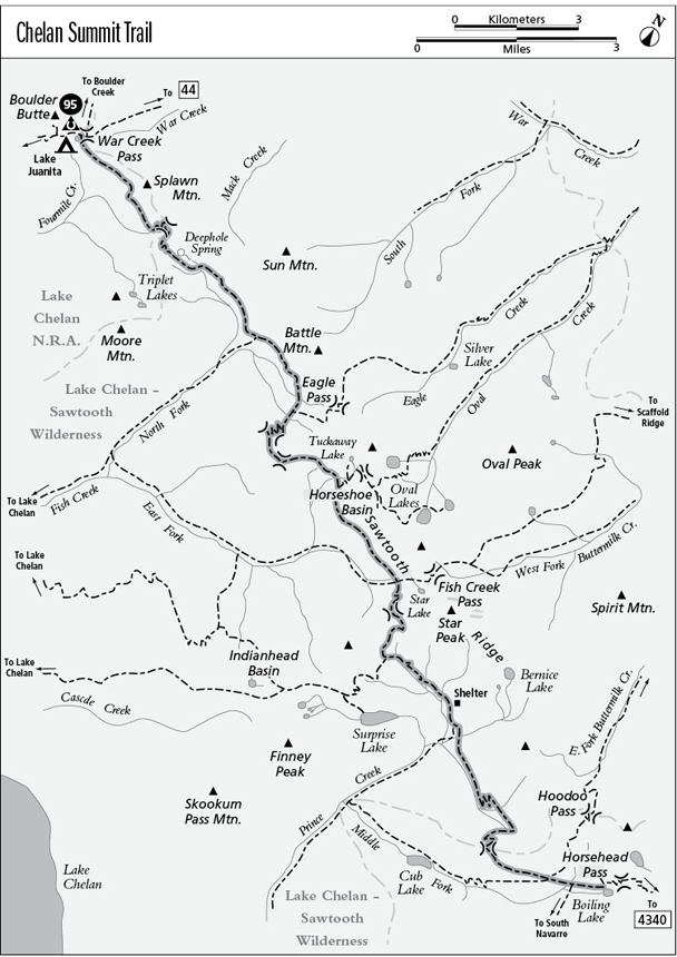
95 Chelan Summit Trail
An extended trek along the timberline meadows of Sawtooth Ridge from Lake Juanita in the north to Boiling Lake in the south, 19.5 miles.
Best season: Early July to early October.
Elevation gain: 6,250 feet (north to south).
Elevation loss: 6,030 feet (north to south).
Maximum elevation: 7,440 feet at the pass between Fish and Prince Creeks.
Topo maps: Sun Mountain, Oval Peak, Prince Creek, Martin Peak; Stehekin, Buttermilk Butte, Prince Creek.
Jurisdiction: Lake Chelan National Recreation Area (North Cascades National Park), Lake Chelan–Sawtooth Wilderness (Wenatchee National Forest).
Finding the trailhead: The route is easiest to reach from the west via the Purple Pass (8 miles) and Boulder Creek (11.4 miles) Trails. From the Twisp River side, it can be reached via War Creek (9.4 miles), Eagle Pass (8.4 miles), Scaffold Ridge (10.5 miles), the West Fork of Buttermilk Creek (9.0 miles), or Hoodoo Pass (7.8 miles).
The Hike
This trail runs the length of the Lake Chelan–Sawtooth Wilderness, crossing the open larch parklands beneath the rugged peaks of Sawtooth Ridge. These high meadows were once the domain of Basque herders, who pushed their bands of sheep through the highlands of the Sawtooth country, then continued northeast into the Okanogan highlands. The trail can be accessed via a network of well-maintained trails that ascend from the Twisp River valley, or from steeper paths rising upward from Lake Chelan. Our description ends at Boiling Lake, just beyond the Wilderness boundary. The southern leg of the Summit trail to South Navarre is part of an ATV playground, a thoroughfare for dirt bikes and other mechanized traffic, and is thus a poor place for hikers to experience the wonder of the mountains.
From the larch-studded meadows at Lake Juanita, the trail runs southeast on a gradual descent across the head of the Fourmile Creek valley. It crosses grasslands where a few whitebark pines and subalpine firs grow. Views across the head of Lake Chelan extend from Castle Rock and Tupshin Peak in the north to the Chelan Mountains far to the south. Closer at hand, the rugged summit of Moore Mountain guards the south side of the Fourmile basin.
At the far edge of the drainage is a shallow basin, and from here the trail climbs aggressively through a stand of subalpine larch to gain the ridgetop and leave National Park Service-managed lands. The trail now turns south, growing faint as it follows the ridgetop through meadows and across bare ground. An old trailbed soon rises from the west to join the main trail; our route now drops onto the eastern side of the ridge. Clearings afford expansive views of Fish Creek’s North Fork, with Deephole Spring rising in a meadowy pocket and sharp crags all around. Loftiest of these are Oval Peak to the east and the multiple summits of Sawtooth Ridge stretching away to the southeast.
The trail drops quickly into the basin below, bypassing Deephole Spring to bring travelers beneath the castellated spires of the nearest summit. After passing through Camp Comfort, the trail turns eastward. It soon reaches the lower mountain slopes that guard the head of the valley. A steady descent leads along the lower edge of a mountain grassland. Near the center of the valley, the trail enters a spruce-fir forest and the gradient lessens. An avalanche slope just before the North Fork junction offers views of the ranges to the west.
After intercepting the North Fork Fish Creek Trail, the Chelan Summit route climbs steadily through the forest. It crosses several open meadows near the head of the valley, but views are limited until the trail reaches the alpine meadows below Eagle Pass. Here, the rocky crags that surround the meadows tower above skirts of subalpine larch. There is a junction with the Eagle Pass Trail at Ten Tree Camp.
A vigorous climb soon leads over a high saddle to the west. The path then turns southwest and continues its ascent across the slopes beyond. A woodland of whitebark pine soon thins to become a grassy savannah, revealing a superb westward vista of the peaks beyond Lake Chelan. The path then crests an even higher ridgetop, and gains a panoramic view of Sawtooth Ridge with its many peaks rising above the East Fork of Fish Creek. The trail drops into a larch forest, then winds across open meadows to reach the Horseshoe Basin.
A spur path runs east into the Horseshoe Basin; it departs from a signpost in Twin Springs Camp, which is beyond the stream that drains the basin. The spur trail climbs a grassy slope beneath vast fields of broken rock. Watch for pikas and marmots among the boulders. In a shallow basin, a cairn-marked route runs across the north slope to Tuckaway Lake, while an abandoned trail climbs the south wall of the valley, bound over the ridgetop to the Oval Lakes.
Meanwhile, the main trail continues southwestward, climbing vigorously through the larches then zigzagging up along the edge of the talus. The trail tops out on larch-studded benches high on the shoulder of Gray Peak, then begins a long traverse across sparsely wooded slopes. The path loses several hundred feet as it crosses grassy meadows that offer stunning views of Star Peak and Baldy Mountain. The trail bottoms out within earshot of the East Fork of Fish Creek, then rises through an ancient grove of subalpine fir with a good campsite. It emerges in the spectacular meadows below Star Peak. Here, signposts mark the junctions with trails leading up over Fish Creek Pass and down the East Fork toward the shore of Lake Chelan.
After crossing the meadows, the trail makes a short but vigorous climb up to the larch-girt divide that stretches between Star Peak and Baldy Mountain. Atop the bald ridge crest, there are fine views of the rugged but nameless summits that crowd the edges of the Prince Creek watershed. The trail descends steadily onto terraces of larch parkland, then wends its way westward through a stand of subalpine fir. Upon reaching a beautiful meadow at the far side of the forest, hikers approach a signpost. The trail to Surprise Lake runs west, while the Chelan Summit Trail descends on an eastward bearing.
After dropping through the forest, the path turns southeast to descend gently across grassy meadows separated by strips of timber. Beyond a talus field, the Prince Creek shelter guards an open slope. The path continues downward to the junction with the Prince Creek Trail; follow the signs for Boiling Lake as the Chelan Summit Trail levels off in a montane stand of Douglas fir and lodgepole pine.
After crossing a series of avalanche slopes, the trail strikes a mountain brook and follows it upward past picturesque pools and miniature waterfalls. Nearing the head of the valley, the path turns northeast to zigzag up through the pines toward what appears to be a low pass. Along the way, there are views of Finney Peak to the west. The “pass” turns out to be a blind amphitheater walled in by ragged cliffs, and the trail ascends into the meadows at its lower edge before turning westward toward the true pass. A level traverse leads across talus slopes and through sparse stands of larch to reach a hanging meadow at the far edge of the valley.
The path skirts the meadow’s edge before climbing the final pitch to the windswept divide above the Middle Fork of Prince Creek, where the trail leaves the wilderness. Parting views of Star Peak are accompanied by a jumbled montage of fresh scenery: Martin Peak at the head of the valley, Old Man Mountain beyond the deep rift occupied by the Middle Fork, and Emerald and Cardinal Peaks rising far to the southwest beyond the waters of Lake Chelan.
The trail now traverses arid and rocky slopes, offering views of Cub Lake in the valley below. It soon turns the corner onto grassier slopes, then descends to bypass a talus field. Just beyond the boulders is a junction with the trail to Hoodoo Pass, the first leg of a scenic high route to Boiling Lake that is recommended as the final leg of the trek. Follow this side trail eastward across meadows frequented by mule deer and black bear. Open meadows high in the basin have a camp with a hitchrail; the unmarked Hoodoo Pass Trail continues east here, while a well-beaten trail runs south to Boiling Lake. This lake marks the end of the recommended route and has a heavily developed camping area complete with picnic tables. The Chelan Summit Trail, now frequented by motorized vehicles, turns south toward South Navarre Camp, while another wide dirtbike path leads southeast over Horsehead Pass.
Miles and Directions
0.0 Trail junction at Lake Juanita.
2.4 Trail crests divide to enter Fish Creek watershed. It now leaves Lake Chelan NRA and enters the Lake Chelan–Sawtooth Wilderness.
3.3 Camp Comfort.
5.2 Junction with North Fork Fish Creek Trail. Continue straight ahead.
6.7 Ten Tree Camp and junction with Eagle Pass Trail. Bear right.
7.2 Trail crosses pass to enter East Fork Fish Creek drainage.
7.7 Second and higher pass.
8.9 Twin Springs Camp and junction with trail to Tuckaway Lake (1.2 miles, moderate) and Oval Pass (1.8 miles, strenuous). Bear right.
10.6 Junction with East Fork Fish Creek Trail. Continue straight ahead.
10.9 Junction with trail to Fish Creek Pass. Continue straight ahead.
11.5 Trail crosses pass to enter Prince Creek watershed.
12.4 Junction with Surprise Lake Trail (0.8 mile to overlook; 2.5 miles to lake; moderate). Bear left to stay on Chelan Summit Trail.
13.7 North Fork Prince Creek shelter.
14.1 Junction with North Fork Prince Creek Trail. Bear left.
17.4 Trail crosses pass into Middle Fork Prince Creek drainage and leaves Lake Chelan–Sawtooth Wilderness.
18.7 Junction with Hoodoo Pass Trail. Turn left for preferred route.
18.9 Junction with Boiling Lake cutoff trail. Bear right at hitchrack.
19.5 Boiling Lake.
Surprise Lake Option
The Surprise Lake trail begins by crossing attractive meadows interspersed with groves of spruce. After rising over a low knoll, the path makes its way around the head of a grassy bowl where marmots have taken up residence. A modest ascent leads upward, reaching the crest of a bare ridge that overlooks Surprise Lake after 0.8 mile. This large body of water lies within a hanging slot valley high above Prince Creek. The craggy summit of Finney Peak rises ahead as the trail traverses across grassy slopes toward the head of the valley. About halfway there, an intersection marks the spot where the Surprise Lake spur departs from the Indianhead Basin Trail and descends eastward to reach the grassy parklands at the head of the lake, for an overall distance of 3 miles.