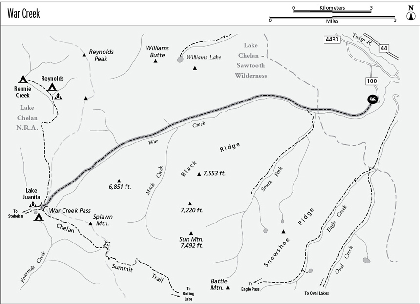
96 War Creek
A backpack from the Twisp River to Lake Juanita, 9.4 miles one way.
Best season: Late June to mid-October.
Elevation gain: 3,670 feet.
Elevation loss: 90 feet.
Maximum elevation: 6,770 feet at War Creek Pass.
Topo maps: Oval Peak, Sun Mountain; Stehekin, Buttermilk Butte.
Jurisdiction: Lake Chelan–Sawtooth Wilderness (Okanogan National Forest), Lake Chelan National Recreation Area (North Cascades National Park).
Finding the trailhead: From Twisp, drive west on Twisp River Road (Forest Road 44) for 14.8 miles. Turn left at the junction with Forest Road 4430, veer right after crossing the river, and turn left again at Forest Road 4430-100. Follow this logging road for the remaining 1.5 miles to the trailhead.
The Hike
This woodland trek passes through a diverse and beautiful selection of forest communities. It lacks mountain views but represents the fastest and easiest route to the north end of the Chelan Summit Trail.
After a steep initial climb, hikers find that the timbered ridges lining the mouth of War Creek give way to the stark talus slopes of War Creek Ridge. The reddish boles of old ponderosa pines punctuate the slopes, and after 1.8 miles the trail reaches a junction with a spur running up the South Fork of War Creek. There are good campsites nearby. The main trail now follows the bottoms through a sun-dappled woodland of mature spruce and Douglas fir. Farther up the valley, open parks filled with young aspen alternate with savannahs of old-growth Douglas fir. Near the confluence of War and Mack Creeks, the trail encounters a historic log cabin that was built to maintain the original telephone line between Stehekin and the outside world.
The trail now begins a long and monotonous grade to War Creek Pass. Heavy timber obscures the pinnacle that guards Mack Creek. Later openings in the trees reveal little more than timbered ridges. Halfway to the pass, the trail enters the 1994 Boulder Creek Burn. When the trees return, they will form a pleasant subalpine woodland. The trail climbs into a flat basin guarded by rocky crags, then ascends into the mixture of meadows, larches, and rock outcrops that guards the approach to War Creek Pass. A vigorous final pitch leads to the pass, and the Boulder Creek Trail joins in along the way.
War Creek Pass marks the boundary of the Lake Chelan National Recreation Area, which is National Park Service domain. Permits are required for camping beyond this point. A brief descent across grasslands leads to the trail’s end at a junction beside Lake Juanita. This tiny pool is surrounded by larch parklands. There is a campground on the western shore of the lake, and trails lead west to Purple Pass and south along the Chelan Summit.
Miles and Directions
0.0 War Creek Trailhead.
1.8 Junction with South Fork War Creek Trail. Continue straight ahead.
5.4 Trail passes old cabin.
9.2 Junction with Boulder Creek Trail. Bear left for War Creek Pass.
9.3 War Creek Pass. Trail leaves Lake Chelan–Sawtooth Wilderness and enters Lake Chelan National Recreation Area.
9.4 Lake Juanita. Junction with Purple Pass and Chelan Summit Trails.

The approach to War Creek Pass