
A nameless crag rises above Eagle Pass
97 Eagle Pass
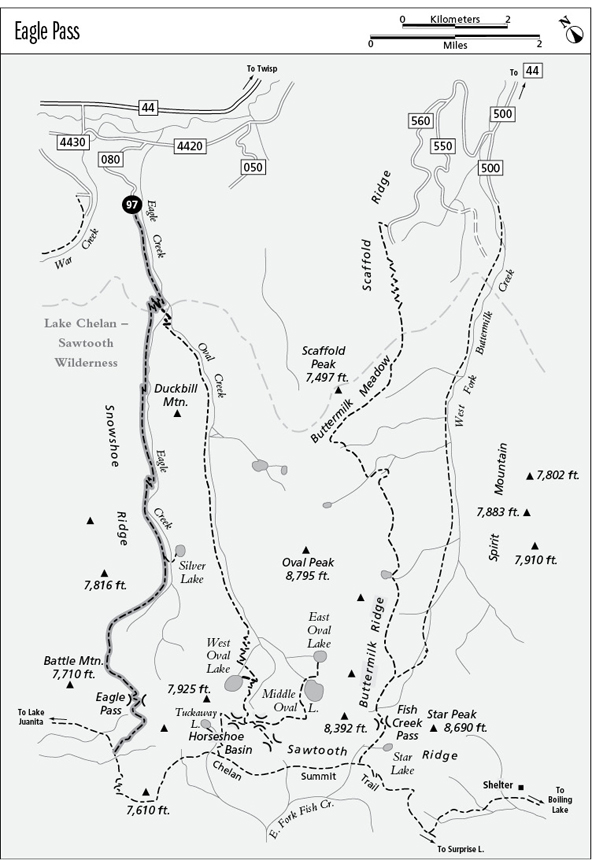
A backpack over Eagle Pass to the Chelan Summit trail, 8.4 miles one way.
Best season: Early July to early October.
Elevation gain: 4,280 feet.
Elevation loss: 700 feet.
Maximum elevation: 7,260 feet.
Topo maps: Oval Peak; Buttermilk Butte.
Jurisdiction: Lake Chelan–Sawtooth Wilderness (Okanogan National Forest).
Finding the trailhead: From Twisp, drive west on Twisp River Road (Forest Road 44) for 14.8 miles. Turn left at the junction with Forest Road 4430, veer left after crossing the river, and then turn right onto Forest Road 4420-080. Follow this logging road for the remaining 1.5 miles to the Eagle Creek trailhead.
The Hike
Arguably the most scenic trail to the Chelan Summit, this challenging route climbs through the valley of Eagle Creek, passing near Silver Lake on its way to the top of Sawtooth Ridge.
The trail begins by wandering up through the bottoms of Eagle Creek, which is loosely timbered in a diverse array of conifers and hardwoods. Upon reaching the confluence of Eagle and Oval Creeks, the path zigzags up past the junction with the Oval Lakes Trail and begins its long and viewless ascent to the high country. Thick timber surrounds the trail for the next 2.3 miles, finally relenting at the top of the grade as the trail passes a drift fence and enters a grassy meadow. There is a good campsite at the far edge of the clearing. A brief climb through the trees leads to talus slopes that offer the first mountain views of the hike. Oval Peak rises prominently to the east, and a look down the valley reveals the distant domes of the Okanogan Mountains.
A nameless crag rises above Eagle Pass
The trail soon levels off as it enters a hanging valley robed in a loose forest of subalpine fir, whitebark pine, and spruce. Along the willow-choked course of Eagle Creek, the trees open up into tidy meadows, which reveal themselves as the path drifts close to the water. A well-marked junction announces the departure of the Silver Lake spur trail, which crosses the parklands, makes a shallow ford (or a difficult leap) across Eagle Creek, and rises onto a heavily timbered shelf to reach the lake.
Meanwhile, the main trail continues its level journey up the valley, then climbs steadily to reach the whitebark pine savannahs high on the shoulders of a nameless peak that rises from Snowshoe Ridge. Superb views accompany the trail for the remainder of the trek, featuring Oval Peak and the nameless crags that guard the headwaters of Eagle Creek. The trail leads upward through flowery glades and stands of larch, finally climbing a steep pitch to gain the summit of Eagle Pass. A stark summit rises ahead, while a northward glance reveals the hulking massif of Gardiner Mountain and the pale summit of Silver Star Peak.
As the path descends into the grasslands to the southwest, westward views open up to reveal the sharp pinnacles beyond Lake Chelan. The path soon winds beneath a steep face of rock, then loops downward through larches and grassy glades to reach the floor of a meadowy basin. The trail ends here at a junction with the Chelan Summit route, and there is a good campsite beside a mountain brook just below the junction.
Miles and Directions
0.0 Eagle Creek Trailhead.
2.0 Junction with Oval Lakes Trail. Turn right for Eagle Pass. Wilderness boundary.
5.0 Junction with spur trail to Silver Lake (0.2 mile, easy). Continue straight ahead for Eagle Pass.
7.3 Eagle Pass.
8.4 Trail ends at junction with Chelan Summit Trail.