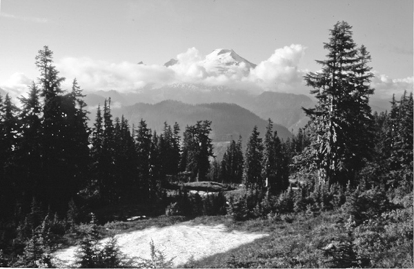
A view of Mount Baker from the flanks of Dock Butte
3 Dock Butte–Blue Lake
A half-day, out-and-back hike to the summit of Dock Butte, 2.0 miles one way, or to Blue Lake, 0.8 mile one way.
Best season: June through September.
Elevation gain: 1309 feet (Dock Butte only).
Elevation loss: 70 feet (Blue Lake only).
Maximum elevation: 5,280 feet.
Topo maps: Baker Pass.
Jurisdiction: Mount Baker–Snoqualmie National Forest.
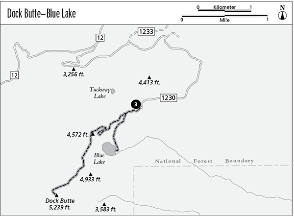
Finding the trailhead: Follow Washington Highway 20 west from Concrete for 5 miles to the Baker River Highway (Forest Road 11) at mile 82.5. Follow this paved road north for 8 miles, then turn left on Forest Road 12 just after entering the national forest. Follow this broad gravel road for 7 miles, then turn left on Forest Road 1230. After 4 miles of narrow, winding road, you will reach the trailhead at its end.
The Hike
This short but vigorous day hike climbs to the summit of a small knob that commands views of the Skagit Valley and Mount Baker. A spur trail down to Blue Lake makes an easier destination and is discussed at the end of this section.
The hike begins in subalpine parklands, where mountain hemlocks rise in clusters between heather-filled glades. These glades indicate locations where persistent snowdrifts linger into early summer, resulting in a growing season that is too brief to support the establishment of trees. The path runs west and then south across the mountainsides, navigating between the summits of wooded knobs, and soon reaches a pass where the trail splits. To the left is the trail to Blue Lake, while the path to the right begins the hearty climb to the top of Dock Butte.
A view of Mount Baker from the flanks of Dock Butte
This trail climbs briskly through the trees, yielding glimpses of Blue Lake and the waterfall that feeds into it. On the north slope of the next knob, a clearing with the first vistas of Mount Baker heralds the approach of the first false summit. The path continues upward, rounding onto west-facing slopes as the trees open up into subalpine parkland.
After dipping to cross a saddle, a calf-burning climb tackles the next summit along the ridgeline. Look northward as you ascend: There are superb views to be had of Mounts Baker and Shuksan, with the Twin Sisters rising to the west. Again the path swings onto the western flank of the ridge, and now the sharp prow of Dock Butte can be seen ahead. The path soon begins to ascend the third major pitch, then swings across the north slope of the butte, almost meeting the ridgeline to the west of the summit. It then traverses back across the north slope to meet the spine of the ridge to the east of the summit, and from here it climbs the ridgetop to reach the top of Dock Butte.
Atop Dock Butte, a former fire lookout site presides over a panorama that includes the jagged peaks of North Cascades National Park to the east, with Lake Shannon and Baker Lake laid out in the emerald folds of the foreground. To the south is the Skagit Valley, where the ravages of clear-cutting have left behind a fragmented forest robbed of much of its ecological health. Glacier Peak is the nearest of the lofty snowcapped summits that rise beyond the valley. To the west, the glittering waters of Puget Sound are framed by the distant Olympic Mountains.
Miles and Directions
0.0Dock Butte Trailhead.
0.2Trail reaches junction in small saddle. Bear right for Dock Butte; turn left for Blue Lake (0.6 mile farther).
2.0Trail reaches summit of Dock Butte.
Blue Lake Option
From the junction, the lakebound path makes a level traverse through open woodlands, then climbs steadily across slopes forested in tall hemlocks. It soon reaches a hillock above Blue Lake, which is tucked in a small cirque carved out by a small glacier, with a slender veil of a waterfall dropping across the cliff that guards its head. It’s an easy jaunt from here down through the trees to reach the foot of the lake.