Middle Oval Lake
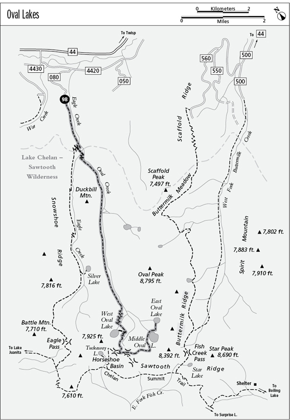
98 Oval Lakes
A backpack visiting all three Oval Lakes, 10.9 miles one way.
Best season: Early July to mid-October.
Elevation gain: 4,850 feet to East Oval Lake.
Elevation loss: 1,170 feet to East Oval Lake.
Maximum elevation: 7,700 feet above Middle Oval Lake.
Topo maps: Oval Peak; Buttermilk Butte.
Jurisdiction: Lake Chelan–Sawtooth Wilderness (Okanogan National Forest).
Finding the trailhead: The hike begins at the Eagle Creek trailhead. From Twisp, drive west on Twisp River Road (Forest Road 44) for 14.8 miles. Turn left at the junction with Forest Road 4430, veer left after crossing the river, and then turn right onto Forest Road 4420-080. Follow this logging road for the remaining 1.5 miles to the Eagle Creek trailhead.
The Hike
This trail climbs to a series of striking cirque lakes beneath the crest of Sawtooth Ridge. West Oval Lake can be reached in a long day hike, but the prettier lakes that lie beyond it require an overnight trip. The trail receives some use by horse parties, but for the most part the horses have had little impact on the landscape of this beautiful drainage.
The trek begins on the Eagle Pass Trail, a wide and dusty thoroughfare that follows Eagle Creek through a ragged woodland of Douglas fir and ponderosa pine. As Oval Creek enters the valley from the southwest, the trail zigzags up to a marked junction at the wilderness boundary. Bear left onto the Oval Lakes Trail, which soon crosses Eagle Creek via a ford of mid-calf depth or a scramble across slippery boulders. The path now tracks the steep gradient of Oval Creek, alternately switchbacking upward and traversing back to the stream. The dense growth of Douglas fir offers scant scenery, and even when the trail crosses the shale slopes below Duckbill Mountain, there is little to see but forested ridges.
Beyond the scree slope, the stream gradient eases and the miles slide by effortlessly. The montane forest is soon replaced by a woodland of spire-shaped spruce and subalpine fir. The trail visits Oval Creek from time to time, revealing miniature waterfalls and crystalline pools. Near the head of the valley, the path passes beneath the towering edifice of Oval Peak. The path ultimately reaches a grassy meadow, and a spur path splits away toward a streamside camping spot.
Middle Oval Lake
The main trail now begins an arduous ascent across steep and timbered slopes. Atop a wooded shelf, the trail levels off and crosses the stream that issues from West Oval Lake. It then traverses to a second watercourse beneath a massive wall of stone, where it zigzags upward into the larches. A marked junction soon presents itself; the main trail is to the left, while to the right a spur trail climbs over a hillock and descends to West Oval Lake. Barren summits surround this high lake, and the sparse growth of whitebark pine and larch along the shoreline offers scant protection from the elements.
Meanwhile, the main trail adopts a steep grade as it climbs into a grassy vale, then redoubles its pace as it snakes upward along a barren spur ridge. There are outstanding views of Oval Peak from this point on. Plant life falls behind as the path climbs onto the barren scree at the base of Gray Peak. As the finger ridge joins the base of the mountain, an abandoned (but still passable) trail grade runs westward over a saddle and descends into the Horseshoe Basin, offering a linkage with the Chelan Summit Trail. The main trail runs south, traversing across the scree to surmount a rocky col. Bear left as the path makes the steep drop into an open basin where rolling meadows are studded with groves of larch.
The trail runs roughly southward now, and steep descents alternate with level meanders across the meadows. A final descent through a spruce woodland leads to the larch-studded flats at the foot of Middle Oval Lake. Guarded by towering peaks, this largest of the Oval Lakes is a superb place to camp. East Oval Lake is nearby; to reach it, cross the outlet stream at Middle Oval and follow a path that first runs toward the lakeshore and then veers east to surmount a low and wooded hillock. A considerable descent leads to the shore of East Oval Lake, which lies at the foot of Buttermilk Ridge and offers fine views of Oval Peak from its shoreline.
Miles and Directions
0.0 Eagle Creek Trailhead. Follow Eagle Pass Trail west.
2.0 Junction with Oval Lakes Trail. Bear left. Wilderness boundary.
2.1 Trail fords Eagle Creek.
7.2 Bottom of grade to West Oval Lake.
7.9 Trail crosses outlet stream that drains West Oval Lake.
8.5 Junction with spur to West Oval (0.3 mile, moderate). Bear left for Middle and East Oval Lakes.
9.1 Junction with abandoned trail to Horseshoe Basin. Bear left.
10.5 Middle Oval Lake. Trail crosses outlet stream.
10.9 East Oval Lake.