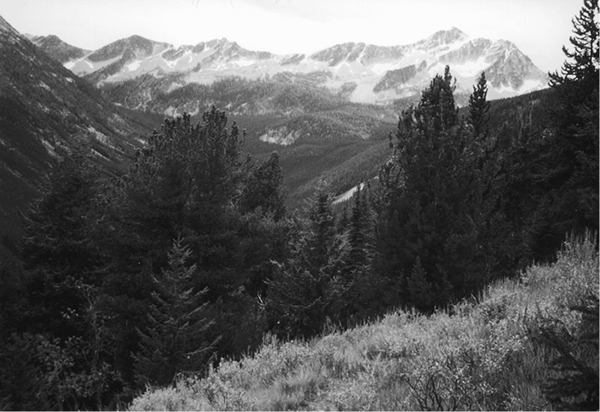
Star Peak from the slopes of Scaffold Ridge
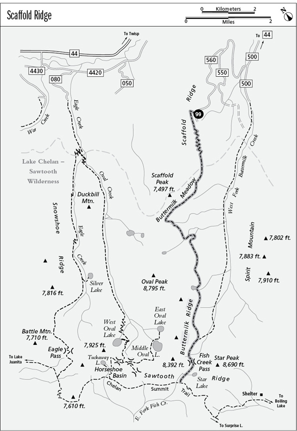
99 Scaffold Ridge
A challenging backpack along Scaffold Ridge to Fish Creek Pass and the Chelan Summit Trail, 10.5 miles one way.
Best season: Late June to mid-October.
Elevation gain: 4,320 feet to Chelan Summit Trail.
Elevation loss: 2,500 feet to Chelan Summit Trail.
Maximum elevation: 7,500 feet at Fish Creek Pass.
Topo maps: Hoodoo Peak, Oval Peak (trail not shown); Buttermilk Butte.
Jurisdiction: Lake Chelan–Sawtooth Wilderness (Okanogan National Forest).
Finding the trailhead: From Twisp, drive west on Twisp River Road (Forest Road 44) for 11 miles. Turn left onto the West Fork Buttermilk Road (County Road 1081), veer left at the split, and after 0.8 mile turn right onto Forest Road 43, following signs for Black Pine Lake. After 3.5 miles, turn right onto Forest Road 43-500, and turn right again at the next junction (unmarked) onto Forest Road 43-550. This narrow road climbs onto Scaffold Ridge and splits. Take the right fork (43-560) and follow it to the wide spot near its end.
The Hike
This remote route follows the high country above the West Fork of Buttermilk Creek and then crosses Fish Creek Pass and descends to meet the Chelan Summit Trail. The Scaffold Ridge Trail receives light use from hunters and horsemen, and up to this time it has been largely ignored by hikers. It visits several beautiful but barren lakes along the way, and there are fine views all along the route. Route-finding skills are a must, since the trail receives light maintenance and is hard to follow in places.
After a killer ascent through the Douglas fir and aspen savannahs, the trail runs southwest to reach a saddle atop Scaffold Ridge. The heavily timbered slopes of Scaffold Peak rise ahead, soaring upward out of sight. The path zigzags steadily up the ridgeline, and occasionally the spruces and lodgepole pines give way to grassy meadows that reveal distant views across the wooded foothills and tawny lowlands to the rounded peaks of the Okanogan Mountains. Near the top of Scaffold Peak, the trail levels off and makes its way onto south-facing slopes where sagebrush meadows afford superb mountain views. Star Peak, tallest summit on the granite backbone of Sawtooth Ridge, rises above the West Fork of Buttermilk Creek, and across the valley is the rugged crest of Spirit Mountain.
Entering the Lake Chelan–Sawtooth Wilderness, the trail glides down across the long band of grassland known as Buttermilk Meadows. Along the way hikers get superb views of the sheer north face of Oval Peak, and below it is a mantle of subalpine larch that turns brilliant gold in October. Upon reaching the bottom of the meadows, the trail climbs westward along its lower edge, shaded by the spreading canopies of mature spruce. There is a dependable spring just beyond the western end of the opening, and beyond it is an unmarked trail junction. Follow the heavily blazed lower path as the route-finding starts to get tricky.
Star Peak from the slopes of Scaffold Ridge
The path wanders down through the formless folds of a gently sloping basin, then runs southward. The trail crosses a stream to reach the boulderfields at the base of a rocky and larch-studded spur of Oval Peak. Working its way along the lower edge of the talus, the trail skirts boggy meadows and then surmounts a low knoll to reach a camping spot beside a spring-fed creek. A steep climb ensues as the trail heads straight up the neighboring ridge, the same rocky spur that was visible earlier from below. As the path crests the ridgetop, take a short jog to the north, where granite outcrops offer fine views of Oval Peak.
A gentle descent now leads across whitebark pine savannahs; sporadic views encompass Spirit Mountain as well as the peaks of Sawtooth Ridge as far east as Mount Bigelow. After a number of minor ups and downs, the path climbs steeply to reach a shallow lake set among the larches below the northernmost horn of Buttermilk Ridge. Leaving the lake, the trail climbs briefly, then descends steeply through the subalpine woodland to reach the base of an impressive talus slope. The path follows the lower edge of this boulderfield and others like it, gaining elevation in steep spurts. Follow the cairns, blazes, and arrows sawed into the trees when the trail becomes difficult to follow.
After a long and vigorous ascent, the trail drops down to meet the West Fork Buttermilk Trail at an unmarked junction. Turn right on the West Fork Trail to continue the hike. The final and spectacular ascent to Fish Creek Pass is guarded by the regal summit of Star Peak. The barren col of the Fish Creek Pass is unmatched for scenic grandeur, with the granite faces of Star Peak soaring overhead, the turquoise mere of Star Lake nestled in the larch parklands below, and views of the angular crags of the Glacier Peak Wilderness far to the west. The trail now drops quickly across loess soil to reach the meadows below, then skirts far to the north of Star Lake as it descends gently to reach its end at a signpost on the Chelan Summit Trail.
Miles and Directions
0.0 Scaffold Ridge Trailhead. Trail runs straight uphill.
2.3 Trail enters Lake Chelan–Sawtooth Wilderness.
2.6 Trail enters Buttermilk Meadow.
3.9 Trail leaves Buttermilk Meadow.
4.8 Trail crosses Spring Creek and begins steep ascent.
6.5 Trail reaches nameless lake.
9.0 Junction with West Fork Buttermilk Trail. Turn right.
9.7 Fish Creek Pass.
10.5 Trail ends at junction with Chelan Summit Trail.