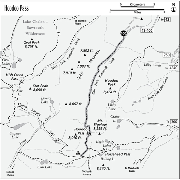
100 Hoodoo Pass
A day hike to Hoodoo Pass, 13 miles round-trip, or a backpack to the Chelan Summit trail, 7.8 miles total.
Best season: Early July to mid-October.
Elevation gain: 2,710 feet.
Elevation loss: 800 feet.
Maximum elevation: 7,450 feet.
Topo maps: Hoodoo Peak, Prince Creek; Buttermilk Butte, Prince Creek.
Jurisdiction: Lake Chelan–Sawtooth Wilderness (Okanogan National Forest).
Finding the trailhead: From Twisp, drive west on Twisp River Road (Forest Road 44) for 11 miles. Turn left onto the West Fork Buttermilk Road (County Road 1081), veer left at the split, and after 0.8 mile turn right onto Forest Road 43, following signs for Black Pine Lake. After 6 miles, turn right onto Forest Road 43-400, following signs for Buttermilk Butte, and follow it for the remaining 2.5 miles to the trailhead.
The Hike
This trail offers the shortest route to the south end of the Chelan Summit Trail. Most of the trail has the tranquility conferred by wilderness status, but views along the way are masked by trees as far as Hoodoo Pass. Beyond this point, the trail enters alpine meadows that have been opened up to motorized vehicles.
For the first 2 miles of the trek, the trail follows an old road grade along the East Fork of Buttermilk Creek. Slide alder, ever the opportunist, has colonized the old roadway wherever there is sufficient groundwater. Talus slopes just beyond the wilderness boundary yield views of Hoodoo Peak and glimpses of Sawtooth Ridge, but for the most part the roadway runs through a viewless forest. As the old road peters out, the trail fords the stream; hikers can clamber across the rocks just upstream. The trail now follows the watercourse closely, and its murmuring will be a constant companion as the path ascends gently through stands of spruce and lodgepole pine. The lodgepoles are the legacy of an intense forest fire that burned here in the early 1900s.
Above the burn, a more open forest of mature spruce provides a scenic counterpoint to the creek. After making a second crossing, the trail climbs moderately through open glades that provide glimpses of the surrounding mountains. The ground is saturated by seeps and springs, and horse traffic often churns the trail into a long succession of mud pits. There is a small camp beside the final stream crossing; this marks the bottom of the grade to Hoodoo Pass.
The path now snakes upward through heavy timber, climbing steeply to reach the subalpine zone. Here, a fringe of larches gives way to a couloir of broken rock that has tumbled down from the blocky cliffs of Mount Bigelow. From the rocky heights of the pass, the eerie pillars of rock known as “hoodoos” can be seen on the mountainside to the south. The trail leaves the wilderness as it makes a surprisingly brief descent into the flat and grassy parklands to the south. It now wends its way down through the larch meadows to reach an unmarked junction beside a horse camp. To the left, a new trail traverses eastward to Boiling Lake. The old Hoodoo Pass trail runs southwest, providing fine views of the regal summit that rises to the north of Martin Peak as it crosses meadows guarded by ancient spruce trees. The trail ends as it joins the Chelan Summit Trail in the upper reaches of Prince Creek’s Middle Fork.
Miles and Directions
0.0 East Fork Buttermilk Creek Trailhead. Trail follows closed road.
2.2 Old road ends and trail fords East Fork of Buttermilk Creek.
4.5 Second crossing of the East Fork.
5.8 Final crossing of East Fork and bottom of grade to Hoodoo Pass.
6.5 Hoodoo Pass. Trail leaves Lake Chelan–Sawtooth Wilderness.
7.1 Horse camp. Junction with connector to Boiling Lake. Bear right for Chelan Summit Trail.
7.8 Trail ends at junction with Chelan Summit Trail.