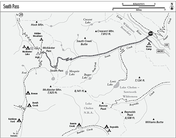
101 South Pass
A day hike to South Pass, 15 miles round-trip, or a backpack to McAlester Pass, 9.9 miles one way.
Best season: Early July to mid-October.
Elevation gain: 3,120 feet.
Elevation loss: 370 feet.
Maximum elevation: 6,320 feet.
Topo maps: Gilbert; Stehekin.
Jurisdiction: Lake Chelan–Sawtooth Wilderness (Okanogan National Forest), Lake Chelan National Recreation Area.
Finding the trailhead: From Twisp, follow Twisp River Road (Forest Road 44) west for 23 miles to the South Pass Trailhead.
The Hike
This trail offers one of the easiest hikes to a high pass in the North Cascades. It follows South Creek through the Lake Chelan–Sawtooth Wilderness, and beyond the divide enters Lake Chelan National Recreation Area, where National Park Service regulations apply. Louis Lake makes a fine side trip from this route, and from trail’s end at McAlester Pass it is an easy descent to McAlester Lake. Beyond South Pass are spectacular alpine meadows with views of McAlester Mountain and the distant peaks to the southwest.
After crossing a bridge over the Twisp River, the trail climbs onto a terrace where it is joined by a spur path from Horse Camp. The trail then enters the South Creek valley, climbing briskly to avoid a rocky gorge at the mouth of the valley. After a short distance, the climbing eases and the path makes its way through open timber that reveals the craggy peaks farther up the valley. A large brushfield offers views of a small but engaging waterfall. Just after the trees return, there is a well-marked junction with the Louis Lake Trail.
Stands of mature spruce now alternate with open slopes populated by aspens, willows, and a variety of shrubs. The sharp peaks that run north from McAlester Mountain appear to the west. After a long stroll up the valley, the trail climbs moderately across the headwaters of South Creek, on slopes cleared by an intense wildfire in 1970. Now wildflowers and low-growing shrubs populate the mountainsides, and superb views abound. The trail makes a few upward switchbacks, then swings south to cross a large talus slope. A zigzagging final pitch leads up through a brushy woodland of larch, fir, and mountain hemlock to reach South Pass, where the trail enters National Park Service lands.
After passing through the notch, hikers emerge onto meadowy slopes across from McAlester Mountain. The path turns northward, traversing steep slopes robed in speedwell, phlox, lupine, and paintbrush. Views are superb during the level trek to the top of a flat promontory. Looking down Rainbow Creek, visitors can see Dome Peak and later Mount Lyall rising prominently among the distant peaks. Due west and closer at hand is the rocky tooth of Bowan Mountain. At the promontory, the trail begins to descend across flower-strewn swales that lead down to McAlester Pass. Watch for marmots as the path makes its final drop into the broad, grassy basin. A signpost marks the junction with trails to Rainbow Creek and McAlester Lake.
Miles and Directions
0.0 South Creek Trailhead.
0.1 Trail crosses Twisp River.
0.2 Junction with spur trail from Horse Camp. Continue straight ahead.
2.5 Junction with Louis Lake Trail. Continue straight ahead.
7.5 South Pass. Trail leaves Lake Chelan–Sawtooth Wilderness and enters Ross Lake National Recreation Area.
9.9 McAlester Pass. Junction with Rainbow Creek and McAlester Lake Trails.
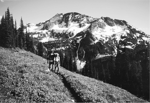
McAlester Mountain from the South Pass Trail